Archaeologia Lituana ISSN 1392-6748 eISSN 2538-8738
2018, vol. 19, pp. 34–61 DOI: https://doi.org/10.15388/ArchLit.2018.19.3
An Overview of Southern Bohemian Hilltop Settlements from Prehistory to the Late Middle Ages
Josef Hložek
Department of Archaeology
University of West Bohemia in Pilsen
Sedláčkova 15, CZ-30614, Pilsen, Czech Republic
hlozek@kar.zcu.cz
Petr Menšík
Department of Archaeology
University of West Bohemia in Pilsen
Sedláčkova 15, CZ-30614, Pilsen, Czech Republic
mensik.p@email.cz
Milan Procházka
Department of Archaeology
University of West Bohemia in Pilsen
Sedláčkova 15, CZ-30614, Pilsen, Czech Republic
mprochi@kar.zcu.cz
The Southern Bohemian Region belongs to regions where many hilltop settlements had been built since the Early Stone Age. However, the first fortified systems were built in the Late Bronze Age, as hilltops, mountain peaks, and promontories were fortified using complex systems of ramparts and ditches. This phenomenon thereafter continued into younger prehistoric periods, especially the Early Iron Age, resulting in the foundation of hilltops in the Early Middle Ages, starting with the 9th century and frequently continuing in the form of castles and manor houses built in the Middle Ages and the Modern Period. This paper is not only an attempt to summarize and survey the use of hilltop sites and the continuity of settlements but also an effort to state their classification, characteristics, and function considering their practical, social and symbolical roles, which can be detected in both prehistoric (sophisticated fortifications with no practical use, relocation) and medieval (show of power, the question of defence) heritage.
Keywords: hilltop settlement, Southern Bohemia, continuity and discontinuity, change over time.
Pietų Bohemijos regiono kalvų gyvenviečių raidos nuo priešistorės iki vėlyvųjų viduramžių apžvalga
Pietų Bohemija – vienas iš regionų, kuriame gyvenvietės kalvose buvo įrengiamos nuo ankstyvojo akmens amžiaus. Tačiau pirmosios įtvirtinimų sistemos, pasižymėjusios sudėtingomis gynybinių pylimų ir griovių struktūromis, kalvose, kalnų viršūnėse ar iškyšuliuose buvo įrengiamos vėlyvajame žalvario amžiuje. Šio reiškinio tęstinumas identifikuojamas ir vėlyvesniais priešistorės laikotarpiais, ypač ankstyvajame geležies amžiuje. Ankstyvaisiais viduramžiais, nuo IX a., šio tipo įtvirtinimai dažnai tapo pilimis, o dar vėliau, viduramžiais ir naujaisiais laikais – dvarų sodybomis. Straipsnyje siekiama ne tik apžvelgti kalvose įrengtas gyvenvietes ir jų raidą, bet taip pat pateikti jų klasifikaciją, charakteristiką ir funkciją vertinant praktiniu, socialiniu ir simboliniu aspektais, kurie identifikuojami tiek priešistorės (sudėtingi įtvirtinimai, neturėję praktinės reikšmės, jų perkėlimas), tiek viduramžių (galios demonstravimas, gynybos klausimai) pavelde.
Reikšminiai žodžiai: kalvų gyvenvietė, Pietų Bohemija, tęstinumas ir pertraukiamumas, raida.
Received: 4/4/2018. Accepted: 12/7/2018
Copyright © 2018 Josef Hložek, Petr Menšík, Milan Procházka. Published by Vilnius University Press
This is an Open Access article distributed under the terms of the Creative Commons Attribution Licence, which permits unrestricted use, distribution, and reproduction in any medium, provided the original author and source are credited.
I. Introduction
This paper concisely provides data on the occurrence of hilltop settlements from the Stone Age to the end of the Middle Ages in Southern Bohemia (Fig. 1), which represents one of the transit regions influenced by the West, North and Southeast. Southern Bohemia belongs to the regions where many hilltop settlements were built starting with the Stone Age. However, the first fortified systems were built in the Early Bronze Age on hilltops, mountain peaks, and promontories, which were fortified using complex systems of ramparts and ditches. This phenomenon thereafter continued throughout the younger prehistoric periods, especially the Early Iron Age, resulting in a rather massive hillfort foundation in the Early Medieval Period; beginning in the 9th century, it lasted with frequent continuity throughout the Middle Ages and the Modern Period in the form of castles and manor houses (for specific period dating, see Tables 1, 3).
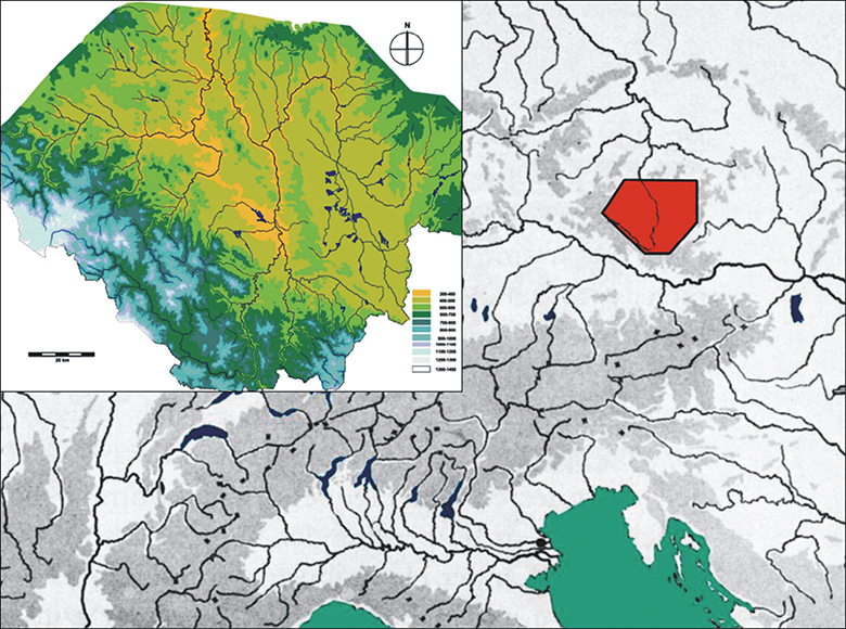
Fig. 1. Map of middle and southern Europe. The Southern Bohemian area is highlighted. Made by P. Menšík.
1 pav. Pietų Bohemija Vidurio ir Pietų Europos žemėlapyje. Autorius P. Menšík
Table 1. The dating of particular prehistoric divisions in Southern Bohemia.
1 lentelė. Atskirų priešistorinių laikotarpių pietų Bohemijoje datavimas
|
Period |
Dating |
|
Palaeolithic |
250000–8500 BC |
|
Mesolithic |
8500–5500 BC |
|
Neolithic |
5500–4500 BC |
|
Eneolithic |
4500–2300/2200 BC |
|
Bronze Age |
2300/2200 BC–750 BC |
|
Iron Age (Hallstatt culture) |
750–420 BC |
|
Iron Age (La Tène culture) |
420–35/25 BC |
|
Roman Period and Migration Period |
35/25 BC–c. 600 AD |
II. Prehistory
The oldest evidence of hilltop settlement sites in Southern Bohemia comes from the Palaeolithic and Mesolithic. However, these cases are represented by temporary though reused hunting camps, often with a distinctive outlook on the surrounding landscape and local watercourses (Vencl et al., 2006, p. 374–376). The Neolithic settlement is characterized by establishing stable and long-term settlements and the building of solid houses as a basis for stable, agricultural life. Neolithic settlements in the Bohemian territory are characterized by the older Linear Pottery and younger Stroked Pottery cultures. In Southern Bohemia, the knowledge of this period is limited, as the density of settlements was probably lower than in the central area of Central Bohemia. The sole pair of well-surveyed and subsequently published settlements so far are located at Žimutice u Týna nad Vltavou (Pavlů, 2001) and Radčice u Vodňan (Michálek et al., 2000). Even though hilltop settlement can be, to a certain extent, found in the Bohemian Neolithic Period, this kind of evidence is missing in Southern Bohemia. In the Eneolithic, Southern Bohemia was less extensively settled, and the traces of human presence are basically missing with the expectation of the Middle Eneolithic Period, as only hilltop settlements connected to the Cham and Řivnáč Cultures appear there. So far, 20 hilltop settlements have been found in Southern Bohemia (Fröhlich, Eigner, 2010; Chvojka, John, Menšík, 2012, Abb. 1; John et al., 2012), all located on prominent sites, as all of them have been placed on promontories with significant cants over river watercourses. They were accessible via heightened places over valleys, by narrow ridges protected by steep slopes from three sides. In the case of Kostelec nad Vltavou, a detachment from the promontory by a trench is evidenced. The sites are generally characterized by small areas of settlement up to 300 square meters. The first environmental samples evidence the presence of an agricultural population.
The earlier stages of the Early Bronze Age (Br A2), (2300/2200–1700/1600 BC) and the transitional period with the Middle Bronze Age (Br A2/B1) represent a major breakthrough concerning the settlement density of Southern Bohemia compared to the Eneolithic. The specific Bohemian Únětice Culture appeared, and the region became a place connecting such cultural areas as Central Bohemia or the Danube region (Hájek, 1954; Chvojka, 2007, p. 29–36). In a number of cases, we can observe an overlap of cultural and symbolic impulses originated from distant areas. In the central area of Southern Bohemia, the evidence of probably uninterrupted human activities can be traced back to this era. One of the possible reasons for the stabilization of settlement networks could be the transport of copper (probably salt, too, as well as other artefacts) from its Alpine deposits, especially the regions of Mitterberg and Salzburg (Chvojka, 2015, p. 115–116). The discovered hoards can indicate the presence of trade routes, especially along river flows, through Southern Bohemia to the central area of the Bohemian Basin with footholds located in their vicinity in the form of hilltop settlements. Both the fortified and unfortified hilltops of Southern Bohemia represent the typical monuments of Early/Middle Bronze Age origin, reaching the total of 32 sites (Chvojka, 2007, Fig. 1; Chvojka et al., 2012, p. 86–89). The majority of hilltop settlements were situated on hill peaks, promontories, or hillocks, and fortified hillforts were to be found at the hill peaks or promontories. The presence of hilltop settlements in difficultly accessed locations highlighted the importance of strategic placement, which can be seen as beneficial for many reasons (Havlice, Hrubý, 2002) knowing that we must now acknowledge the multiple functions of these settlements, such as the practical, social, and symbolic (Neustupný, 1995; Chroustovský, 2015). However, it must be said that knowledge about the functional features of Southern Bohemian Late Bronze Age hilltops is limited due to insufficient research. Systematic surveys have been conducted at Mříč-Dívčí Kámen and Vrcovice, and less extended excavations in particularly at Dobřejice, Chřešťovice, Opařany, Skočice, Slavňovice, Všemyslice, and Zvíkovské Podhradí. The present fortification system has been surveyed at Vrcovice (Hlásek et al., 2015), where it consisted of two rampart lines. The inner rampart, with a dry frontal stone revetment wall, had an inner beam construction with stone-clay filling, supported by stakes recessed into the bedrock in the rear. A similar construction has been discovered in other Southern Bohemian Early Bronze Age hilltops, such as Dobřejovice, Týn nad Vltavou, or Všemyslice (Chvojka, 2007, p. 32). The dating of other sites, usually with poor quality documentation, as in the case of Mříč-Dívčí Kámen, or those of polycultural character, can be found uncertain at least. It seems that the fortification systems of Southern Bohemian Early Bronze Age hillforts are different from contemporary sites in Central and Eastern Bohemia, where only shallow ditches with no above-ground ramparts can be found. Southern Bohemian hill-top settlements, thanks to the thickness of their fortification systems, as well as the usual use of stone and building techniques, stand very close to the Ottomány-Maďarovce-Větěřov group. The hillforts have been frequently and intensely surveyed; the majority of them provided numerous assemblages from this period (Hlásek et al., 2015a, p. 244–246, Tab. 37). With the upcoming Middle Bronze Age (1700/1600–1300 BC), the hilltop settlement fades away, as these settlement types are evidenced at only 5 sites. An intensified use of hilltop settlements then followed in the Late and Final Bronze Age (cf. Hrubý, Chvojka, 2002). In this period, the quantity of central hilltop settlement evidence grows across Central Europe. Overall, there are 19 documented sites in Southern Bohemia belonging to the Knovíz Culture, but the level of information here varies (Chvojka, 2009, p. 138–144; Chvojka et al., 2012, p. 88, Abb. 4). Southern Bohemian hilltop settlements are located in the centers or peripheries of microregions, while none of them are located outside the settled areas. The majority of Bohemian hillforts present in the Late Bronze Age (1300–1000 BC) settlements were divided into at least two areas (acropolis and bailey); their dating, however, remains questionable. The sole unambiguous Southern Bohemian fortification (dated back to the Late Bronze Age) can be found at Hradiště u Písku, where stone destruction has been found within the rampart. This destruction seems to be oval in ground on the southern side of the acropolis (Chvojka, 2007, p. 47). The Chřešťovice Hillfort is also fortified, but its dating remains disputed, and in the case of other abovementioned sites, no fortification has been documented. Moreover, no evidence of settlement features has been acquired whatsoever at these sites. In Southern Bohemia, nine hilltop sites are known and dated to the Final Bronze Age (Chvojka et al., 2012, p. 88, 93, Abb. 5). With a large number of cases, the sites located on promontories as hill and hillock peaks seem to be less common. The total area varies between 0.5–12 ha, with the most common size being 2–5 ha (Hrubý, Chvojka, 2002, p. 585–587). Unfortunately, any knowledge regarding the majority of these sites is limited due to both the absence of modern excavations and especially the polycultural character, which makes dating ambiguous (Chvojka, 2015, p. 114–118). A fortification, radiocarbon dated to the Final Bronze Age (1010–890 BC; 1010–840 BC), can be found at two-part Voltýřov Hillfort (Smejtek, 1984; 2011, p. 321, Fig. 263; Čtverák et al., 2003, p. 343–346). At Voltýřov, a rampart has been found with a frontal stone revetment wall that had been built in the first phase, with the additional core of the rampart – a burned construction made using stones interspaced with thick oak round locks – having been built in the second phase (Čtverák et al., 2003, p. 344). The same dating has been given for the stockade bedding trench at Nezvěstice (Drda, 1987, p. 525, Fig. 4:g). As fortification systems at other sites have not been surveyed using modern approaches, knowledge about the inner area of the Final Bronze Age hillforts is either insufficient or has not been published so far, we only know of a settlement feature with a sunken storage vessel and a hearth from Zvíkovské Podhradí (Chvojka, 2007, p. 44) and the remains of an oven from Voltýřov (Smejtek, 1984, p. 135–137).
The development of distinctive farmsteads and older hillforts probably continued well into the 8th and 7th centuries BC in a similar way we know from the end of the Bronze Age. The Late Hallstatt period represents one of the peaks of the hilltop site and hillfort usage from the beginning of the 6th century, continuing into the end of the 5th century BC. New sites were built in variable conditions, generally with a significant cant over the surrounding landscape (promontories, hilltops, terraces, edges, and ridges of mountain chains). Fortifications placed on distinctive promontories were built divided into divisions, and were slightly arcuate-shaped. Circumferential fortifications are also known, especially on hilltop-built hillforts. Extensive sites are expected, but much smaller ones are known, too, comprised of profound fortifications made by a section ditch and circumferential wall. Another type of small entrenched sites is represented by fortified manor houses situated on the terrace edges over watercourses. The inner areas of fortified sites usually vary from hundreds of square meters to several dozen hectares and are situated at considerable altitudes. No evidence of fortification was found in a number of Southern Bohemia sites; only pottery findings are known (e.g., Bechyně, Jáma, Lazec: Hrubý, 1998, p. 8–10). Fortified hillforts are situated on both the edges of settlement areas and inside the settled regions (Chvojka et al., 2012, p. 93, 96, Abb. 6), and while some of them lie straight over the watercourses, others are located on high-elevation locations in the Bohemian Forest (Obří Hrad u Studence, Věnec u Lčovic, Sedlo u Albrechtic). Their walls were usually built using dry stone wall constructions, and the gateways usually had side wings (Libětice, Skočice, Třebanice) with a tongs gate also being evidenced (Věnec u Lčovic) (Michálek, 2007). Unfortunately, without a wide archaeological excavation and evaluation of the overall settlement of the Southern Bohemian Hallstatt period, it is impossible to attribute any specific functions and roles to individual hillforts and hilltop sites. The archaeological excavation of the Hrad u Bud hillfort points to possible ceremonial function of the whole fortified area (Dreslerová, Hrubý, 2004). A significant, closely excavated site is represented by a princely Hallstatt farmstead of Hradec u Nemětic, interpreted as the seat of the elite (Michálek, Lutovský, 2000). The overall area is fortified with a ditch and a wooden stockade with a simple entrance, and its form does not correspond to any contemporary settlements and hillforts as it is rather similar to the Herrenhof-type sites located west of the Bohemian area. From the beginning of the 2nd century BC, fortified centers, called oppida, were being founded. They are considered to be the administrative centers of both larger and smaller areas, having extensive commercial contacts. One of the basic characteristics of the Bohemian oppida are their ostentations within the surrounding landscapes (Chvojka et al., 2012, p. 96, Abb. 7). Their inner areas, always protected with massive fortifications, vary between dozens of hectares and up to more than 100-hectare areas. Some of them are divided into a central areas, extramural settlements and, in certain cases, unfortified baileys. The Oppida of Nezvěstice and Třísov are located in Southern Bohemia together with smaller fortified areas called the castella (Albrechtice-Sedlo, Lčovice-Věnec, Týn nad Vltavou, Zvíkov) and unfortified hilltop settlements (Čtverák et al., 2003, p. 17–18). The oppidum of Nevězice was fortified with a wall 1650 meters in length, enclosing an area of 13 hectares. The entrance to this area led from a 120-meter-wide neck from the northwest, where the wall was reinforced with a pair of outer trenches. The less steep side vales were also fringed by another forward trench 800 metres in length. The frontal side of an originally 5-meter-wide wall was made of a massive quarry stone wall. The outer side of the wall was completed using vertically placed, 30 × 30-centimeter-wide frontal beams with 0.7–1.3-meter spacings. The wall itself was linked to the clay dyke by a dense timber-laced system. The original height of the wall has been estimated to 3–3,5 meters. The outer ditch had a cuspidate shape with a maximum width of 3–4 meters and around 1.5-meter in depth. Another trench, which protected both the neck as well as the whole southern and western sides of the site, reached a width of 5–6 meters and a depth up to 1.8 meter. The entrances to the hillfort were secured with two features, the northern gateway and a south-eastern tongs gate (Dubský, 1949, p. 378–379; Drda, 1987; Waldhauser, 1993). The artificial fortification of the Třísov Oppidum is protecting the settlement from the western and south-western sides; therefore, the fortified area merges with the surrounding terrain almost fluently. The fortification is formed by two parallel walls fringed by deep cuspidate trenches from the outer side. The space between the ramparts is 15–20-meter-wide and was separated by low transverse walls. The inner timber-laced rampart had a frontal stone revetment wall, originally 4–5-meter-high. The front was reinforced with vertical stakes with an approximately 2-meter spacing and two horizontal lines of flat, vertically-placed stone plates. The outer wall was made of a timber-clay rampart with a frontal wall. Both ramparts were breached with paved tongs gates belonging to a complicated ground plan with inside-cranked wings. The gate fortification was completed with a rampart guarding the access to a water spring. The eastern side of the hillfort was also fortified by a tongs gate with the entrance toward the Vltava River. The oppidum itself occupied an area of 26 hectares with two acropoleis between which a dense settlement has been evidenced in the form of an overground stakehole or sunken features. Traces of artificial terraces have also been discovered. The southern acropopis probably served as a seat of the elite, while the northern one is usually interpreted, based on the octagon-shaped building, as a cult district (Dubský, 1949, p. 372–378; Břeň, 1966; 1967; 1971; 1975).
The era at the end of the last millennium BC and approx. the first six centuries AD is characterized by the arrival and presence of the Germanic population in the Southern Bohemian space. Although certain cultural elements resemble the previous period, the settlement pattern is limited for its use of planar, unfortified settlements of agricultural character. Some sites demonstrate an above-standard extent, including the concentration of specialized production and commerce. So far no site of the Roman and Migration Periods has provided any evidence of fortification (Chvojka et al., 2012, p. 96. Abb. 8), though the rather featureless Germanic activities have been evidenced in older hillforts (Sedlo u Sušice: Zavřel, 2000, p. 153–160; Zvíkov: Zavřel, 1999, p. 497, 502, Fig. 4) and in the Třísov Oppidum. The latter’s character, however, remains ambiguous.
III. The Early Middle Ages (c. 600–1200 AD)
The last phase of the evolution of prehistoric fortification continues to and ends in the Early Middle Ages. From the 7th century AD, it is possible to document various kinds of stockades as well as other kinds of wooden walls, cuspidate trenches, (eventually) lower ramparts, and other simple fortification features; however, their number remains limited up to the 8th century AD. Moreover, prehistoric fortifications were often reused. The change occurred in the first half of the 9th century together with the rising of the Bohemian elite. Older, simpler fortifications were substituted for more complex ones combining timber, clay, and stone. Hillforts were both enclosed and internally divided using timber-clay walls of different construction, from simpler testaceous to more demanding timber-laced and girder constructions. Walls both thick and high in several meters were enforced by building dry frontal stone revetment walls (Čtverák et al., 2003, p. 18–20). During the Bohemian area, the beginning of the Early Middle Ages may possibly be connected with the Prague Type pottery dated to the 6th and the larger extent of the 7th centuries AD. This type can be found in a wide area from Ukraine to Bohemia and Saxony and is commonly associated with first Slavs who replaced, and probably assimilated, the native Germanic inhabitants. The situation is, however, problematic in the Southern Bohemia, as no evidence of either Germanic or Slav settlements is present. It gradually appears in the late 7th century (Lutovský, 2011, p. 178–183). Although the first traces of hilltop settlements are evidenced at Bechyně or Týn nad Vltavou, it is impossible to assess whether the fortifications were new or secondarily used, as fortified settlements at these sites are evidenced and dated to the prehistoric period. In the 8th century, the number of Southern Bohemian sites increased compared to previous periods; the density of the settled areas was rising, and the movement to hilltop sites and less fertile areas is also observable here. The featureless, unfortified settlement of the hilltop sites continues, and the secondary use of older hillforts is also present. However, a new phenomenon emerges as new, distinctively placed hillforts are founded. Regarding the whole course of the 9th century, it is possible to consider the coexistence of eleven sites: Bechyně, Branišovice, Hudčice, Katovice, Kuklov, Libětice, Litoradlice, Němětice, Písecká Smoleč, Řepice and Soběslav (Chvojka et al., 2012, p. 96, 100, Abb. 9–10). The hillforts form an approximately regular network of sites spreading across the settled landscape; their form and placement is, however, heterogeneous. Based on the current knowledge of fortification features, it is possible to assume frontal stone revetment walls with timber-laced elements. However, it is not possible to clearly identify a distinctive center of power within Southern Bohemia; the only expressive area arises in the Central Otava Region (cf. Michálek, Lutovský, 2000), as a network of massive, fortified hillforts is present here (Hradiště u Litoradlic, Hradec u Řepice and esp. Katovice – Kněží hora, which surely was, with its acropolis, three to four bailies and an overall size exceeding 10 hectares, an important, transregional center). These three hillforts are complemented by a small fortified settlement of Hradec u Nemětic, probably a seat of the local elite. At some point in the early 10th century, all of the abovementioned hillforts ceased to exist; incidentally, traces of fire are present. Especially Hradec u Němětic holds solid evidence of a violent demise. At the edge of the hillfort, the remains of wooden, hammered buckets (probably used to extinguish fire) have been found together with many iron arrowheads. The majority of militaria are represented by Early Middle Ages specimens with sockets and airleons, and in 27 cases, the stud type also appears, traditionally associated with the nomadic environment (in this case, the Early Hungarian horizon). The question remains whether the demise of Hradec u Němětic – together with other contemporary hillforts – was influenced by a sudden invasion of several nomadic groups in synch with Moravian rulers into the Southern Bohemian area (Lutovský, 1999; 2000) or a little later, by warriors of the rising Přemyslid dynasty from Central Bohemia (cf. Lutovský, 2011, p. 212–213). The fact remains that the influence of Southern Bohemian rulers recedes in the first decades of the 10th century; no later than around 950, their seats are destroyed or abandoned, and their land, as well as the whole Bohemian Basin, comes under the influence of the Přemyslids, ruled by Duke Boleslaus I. In the second half of the 10th century (eventually at the beginning of the 11th century), a network of new hillforts emerged, becoming the new administrative centers of the Přemyslid state for two following centuries (Lutovský, Michálek, 2007). However, the centers were not extensive, and their fortifications enclosed only smaller sections. It is also possible to consider a gradual expansion of those sites where more bailies were added to their acropoleis. The western part of Southern Bohemia was controlled with the Prácheň Hillfort, with the hillforts of Netolice and Doudleby founded further to the south. Jindřichův Hradec probably served as the southeastern center, Chýnov being the northeastern one. New hillforts are mentioned in the annals of the 12th century, and settlement at these sites usually continues up to the High Middle Ages, often in the form of medieval castles. Although the political and economic importance of these sites is undisputed, their influence did not reach the level of certain Central Bohemian centers. Moreover, Southern Bohemian hillforts also became the centers of Christianization as later reconstructions of sacral buildings is evidenced (Lutovský, 2011, p. 220–221). In the beginning of the 12th century, the administrative functions of the hillforts were taken over by castles and newly founded cities like Horažďovice or České Budějovice.
IV. Case Study I: An Example of Hilltop Settlement Continuity
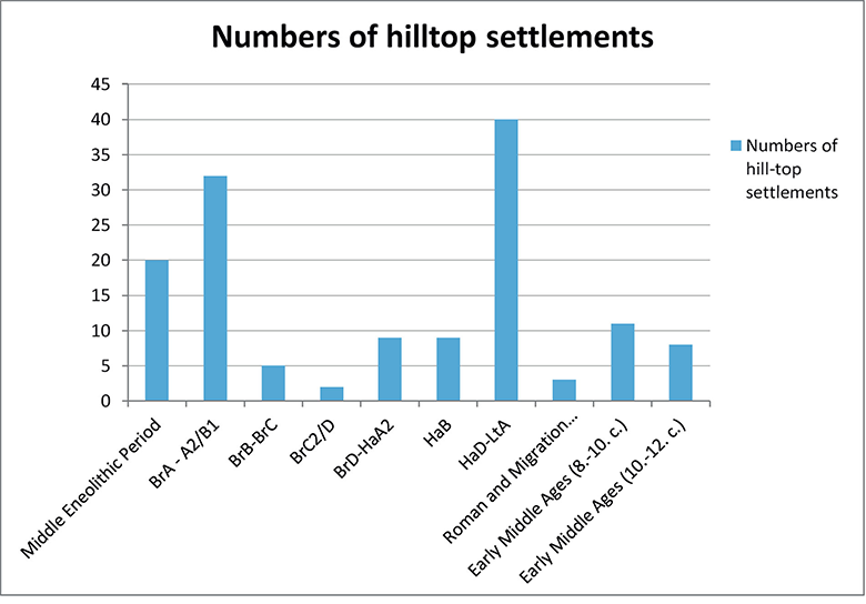
In Southern Bohemia, the number of hilltop settlements during different the Prehistoric and Early Medieval phases significantly diverged throughout both periods (Table 2). The highest hilltop settlement representation can be observed during the Earlier to the Earlier-Middle Bronze Age transition period. Although it is possible to find sites settled in a single period, there are cases of multiple period settlement. The following cases represent an example of three hilltop sites with continual settlements in several Prehistoric and Early Medieval periods. The selected sites are located near the central part of Southern Bohemia, in the Otava river basin.
Table 2. An overview of the settled hilltops in individual prehistoric and early medieval periods in Southern Bohemia.
2 lentelė. Apgyvendintų kalvų atskiruose priešistoriniuose ir ankstyvųjų viduramžių laikotarpiuose pietų Bohemijoje apžvalga
The first example is represented by one of the best-preserved early medieval hillforts in southern Bohemia, the Kněží Hora u Katovic (Fig. 2–4). As for the Middle Hillfort Period, the Katovice region is known as one of the most significant regions of the Early Middle Ages in southern Bohemia. In total, four hilltop settlements existed here; Katovice, Libětice, Hradec u Řepice, and Hradec u Nemětic.
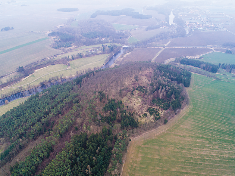
Fig. 2. The Katovice Hillfort. View from the west – an RPAS image. Photo by J. Plzák.
2 pav. Katovice piliakalnis. Vaizdas iš vakarų, nuotoliniu būdu pilotuojamo orlaivio (RPAS) nuotrauka. Autorius J. Plzák
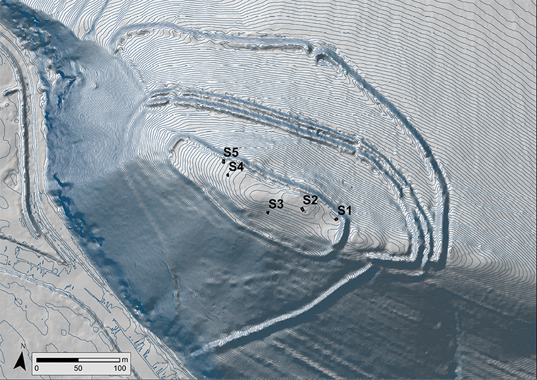
Fig. 3. Katovice. Site contour plan according to the LLS. The distance between contours is 20 cm. S1 to S5: Excavation trenches from 2016. Made by P. Menšík and J. Plzák.
3 pav. Katovice. Archeologinės vietos kontūrinis planas pagal lazerinio skenavimo iš oro (LLS) duomenis. Tarpas tarp izohipsių – 20 cm. S1–S5: 2016 m. tyrimų plotai. Autoriai P. Menšík, J. Plzák
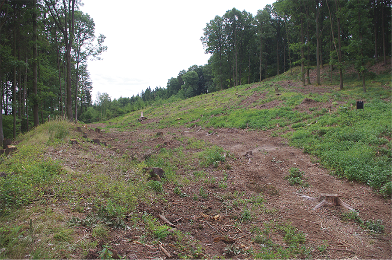
Fig. 4. Katovice. The inner bailey with ramparts on both sides. Photo by P. Menšík.
4 pav. Katovice. Pylimais įtvirtintas papilys iš vidaus. P. Menšík nuotrauka
Although the Katovice Hillfort has been known since the 19th century, a minor excavation was first conducted by B. Dubský in 1946, and larger trenching was done later by P. Menšík in 2016 and 2017. Moreover, geodetic documentation was made, and environmental samples were collected. The hillfort reaches the size of 8 ha (including the acropolis, inner and outer bailey) and has well-preserved and complicated fortifications. The westward part of the hillfort was protected by steep slopes and enclosed with multiple rampart lines. The central part, the acropolis, occupies an elongated plateau and is fortified from all sides, but divided by a pathway running eastward and westward. The bailey’s rampart is strongest on its western, northern and eastern sides; the western rampart’s inner cant reaches up to 2–3 meters, and the northern, more accessible part rises up to 4 meters. The rampart’s cant then reaches a height of 1–1.5 meters on the southern side. Although no forward ditch has been found in the inner bailey, there is a ditch in the inner side of the rampart encircling the acropolis, which is evident along the whole length of its southern part, reaching a depth of 0.5 meter and a width of 3 meters. The ditch is more evident in the central part of the inner acropolis’s rampart, where it reaches a depth of 1 meter and a width of 4 meters. The structure of the acropolis’s entrances remains unknown for it is only evident as a simple disruption of the rampart. There is also a pair of ramparts between the inner and outer bailey, the height of which reaches up to 6 meters. The outer bailey is adjacent to the inner one and is protected by a rampart with a ditch, connected to the abovementioned rampart on its eastern and western sides. The whole fortified area widens westward, creating a rather large and monolithic area. The hillfort is enclosed by an inner rampart 640 meters in length, reaching a height of up to 6 meters. There is also a small ditch in front of the rampart, the width of which does not exceed 3 meters, while its depth amounts to 0.75 meter. Another rampart with a trench digresses eastward from the rampart of the inner bailey and is heading downhill toward the Otava River in the southwest. Its width locally reaches 5 meters with a height of 1.5 meter from the western, and up to 4 meters from the eastern side. Diverting from the inner bailey is a plateau with the possible remnants of a rampart, heading southeast and meeting a rampart heading southwest over the Otava River floodplain; together, both ramparts form a triangulate area that may have represented another bailey. The original entrance to the outer bailey is located on the northern side of the outer bailey rampart, represented by a frontal funnel-shaped gate. Despite the fact that the inner construction of the fortification is insufficiently known, it can be assumed that the construction was probably timber-laced with a frontal dry-laid wall. Locally, it is possible to observe stone rubble with burned-out clay and timber construction imprints. Therefore, it may be assumed that at least a part of the wall was destroyed by a fire, and it is also possible that the fortification had not been built in one stage but rather in several. Apart from the abovementioned findings, a ravine has been detected based on an LSS survey, running up the southern slope from between the first and second rampart and the inner and outer bailey. The entrance to the inner bailey is located in the northwestern part of the fortification and is represented by a simple rampart breach.
A unique discovery has been made when another possible fortification system was found in a field northeast of the hillfort. Although the majority of the rampart is still visible on the field, its continuation, connection to existing ramparts, or entrance are no longer distinguishable. According to some scholars, it is not possible to clearly identify the rampart on the field, even though it seems that that there is a bigger amount of spatially limited stone accumulations (Dubský, 1949, p. 586–597; Lutovský, 2011, p. 157–160; Menšík, Král, 2017; Menšík, Plzák, 2018; Menšík, Procházka, Král forthcoming). Based on the survey conducted in the last two years, signs of settlement have been found from the end of the Palaeolithic and Mesolithic, Early Eneolithic, Late Bronze Age, Hallstatt, La Tène, and Late Middle Age periods. However, the hillfort held the most significant role in the Early Middle Ages (from the 8th and 9th centuries until the beginning of the 10th century). At that time, the site was probably fortified manifold, and an occupation layer has been found in the trenches at the acropolis together with some sunken features. During a partial excavation of the rampart, remnants of a frontal dry-laid wall were found with the remains of a timber-laced construction. A larger amount of pottery from this period has been found with spindle whorls and loom weights evidencing the presence of textile production. Furthermore, some other iron finds were discovered, such as nails, horseshoes, and knives. Moreover, many animal bones indicate animal breeding, especially pigs.
The second site, Nemětice, is represented by a Hallstat farmstead and an Early Medieval hillfort (Fig. 5–6). However, the earliest settlement of this site can be dated back to the Upper Palaeolithic and Mesolithic. The area is not geomorphologically delimited from the western and northern sides, and both fortifications built in the Hallstatt and Early Medieval periods at the same place defined an oblong shape the size of 1 hectare. Unfortunately, the site has been ploughed; the fortification is thus no longer visible. Fortunately, it has been documented by several surveys (Dubský, 1949, p. 203–205, 582–586) and especially by a one conducted by J. Michálek during 1982–1983 and 1988–1989. The full extent of the site, encircled by a ditch and a stockade from the west and north, was later delimited by a combination of geophysical and aerial surveys. The outer ditch, 4–6-metres-wide and 0.6–1-metre-deep, encircled the area of 70 × 140 meters. Following the ditch was a double palisade, keeping a 6–12-meter distance from the ditch. No fortification has been found above the steep slopes. There was also a large stakehouse in the inner settlement together with a few other sunken features. The farmstead is, based on pottery finds, dated back to the 6th century BC. After approx. 1300 years, an Early Medieval hillfort was founded at the same location. A rampart was also founded, possibly of timber-laced reinforcement with a frontal stone revetment wall. Unlike the previous settlement, the medieval hillfort was protected by an additional fortification at the eastern part of the promontory. The inner area of the hillfort was divided in twain parts by a ditch (8-meter-wide and 1.3-meter-deep) followed by a stockade. There was apparently only a single feature in the outer bailey, situated in the southwest corner. The central part of the inner area contained two buildings with a dry, stone wall bedding and a possible seat of the elite, or perhaps a gathering place. Other buildings were found situated along the acropolis’s northeast fortification. Burnt layers, burned-down houses, and destroyed walls, together with more than 100 darts, bear witness to the violent demise of the site. Therefore, many finds have been preserved, especially objects of daily use. The hillfort dates back to the second half of the 9th century, and its violent demise can be traced to the turn of the 9th and 10th centuries (Michálek, Lutovský, 2000; Lutovský, Michálek, 2002).
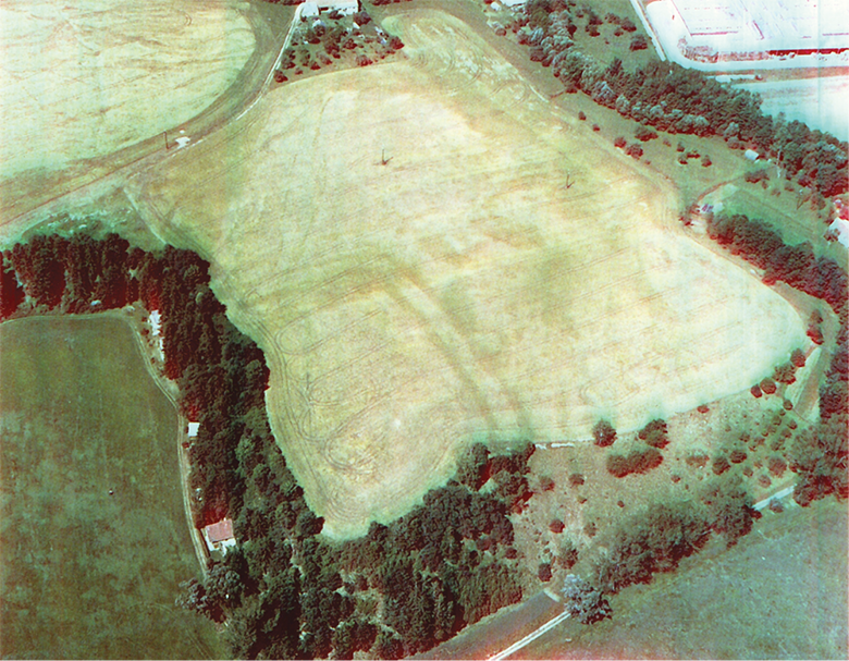
Fig. 5. Hradec u Němětic. An aerial photo of the elite residence from the Hallstatt Period/Early Middle Ages. Photo by J. Michálek.
5 pav. Hradec u Němětic. Halštato / ankstyvųjų viduramžių laikotarpio elito rezidencija. Nuotrauka iš oro. J. Michálek nuotrauka
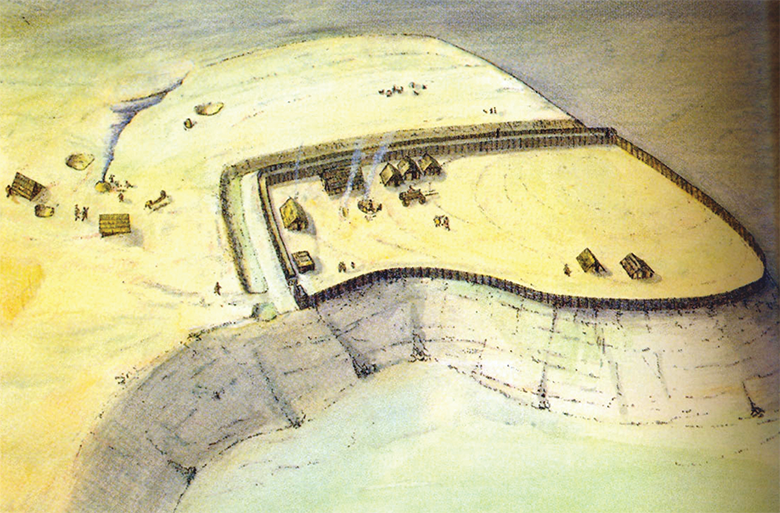
Fig. 6. Hradec u Němětic. A reconstruction of the elite residence from the Hallstatt Period. Made by M. Ernée.
6 pav. Hradec u Němětic. Halštato laikotarpio elito rezidencijos rekonstrukcija. Autorius M. Ernée
The next site is the Skočice Hillfort, one of the central locations of the late Prehistoric Period (Fig. 7–8). The peak of a distinctive hill was built-in on the basis of a two-part hillfort reaching a total extent of 0.9 hectare. Apart from a glacis northeast of the hillfort, all sides are protected by steep slopes. The acropolis consists of a platform (50 x 20 meters), exceeding the bailey by 5 meters. The acropolis itself is fortified only from the eastern part by an arcuate stone rampart and continuously melting into the fortified bailey. There is an extensive bailey connecting with the acropolis from the northern side, the dimensions of which are approximately 80 x 100 meters. The bailey is encircled by a thick stone wall (330 meters in length), which was faced from the frontal side and added with a clay dump from the inner side. The groundwork of the wall probably did not exceed 4 meters. There is also a 24-meter-long street gate in the eastern wall, which did not exceed a width of 2.5 meters. A more recent entrance to the hillfort was located on the northern side. The hillfort has been known from the end of the 19th century, and was, apart from some minor excavations and surveys, excavated by B. Dubský in the 1920s and by J. Poláček in 1963–1974 (Dubský, 1949, p. 197–201, 617–618; Hrubý, Lutovský, 2000, p. 474; Hrubý, Chvojka, 2002, p. 615), and minor augering was conducted in 2009 together with a geodetic survey (Chvojka et al., 2013). Traces of the first human settlement here can be dated back to the Palaeolithic-Mesolithic and Middle (possibly) Eneolithic. The majority of the finds date back to the Late and Final Bronze Age as well as the Hallstatt, La Tène, and Early Middle Age periods. Due to the level of knowledge, it is not yet possible to date neither the occupational layer nor the fortification itself. Several artefacts demonstrate textile (loom weight) and metallurgic (mould) activities in the Earlier Bronze Age. However, we cannot say when the fortification was built, when the hillfort had a residential function, and when it was occasionally settled (Fröhlich, Lutovský, Michálek, 2004; Chvojka et al., 2013).
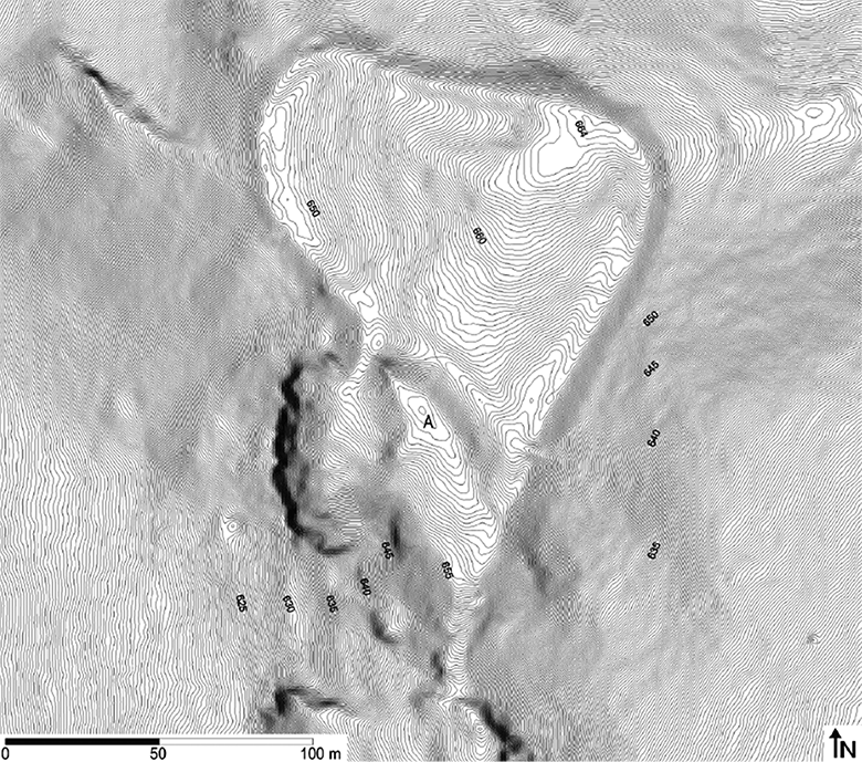
Fig. 7. Skočice. Site contour plan according to the LLS. The distance between contours is 20 cm. A – acropolis. Based on to Chvojka et al., 2013, Fig. 5.
7 pav. Skočice. Archeologinės vietos kontūrinis planas pagal lazerinio skenavimo iš oro (LLS) duomenis. Tarpas tarp izohipsių – 20 cm. A – Akropolis. Pagal Chvojka et al., 2013, fig. 5
Fig. 8. Skočice. View on the outer bailey from the southeast. Photo by P. Menšík.
8 pav. Skočice. Įtvirtinto papilio vaizdas iš išorės. P. Menšík nuotrauka
V. An Example of the Use of Strategic and Hilltop Sites for Castle Foundations in the High and Late Middle Ages (1200–1500 AD)
In the beginning of the High Middle Ages, a new phenomenon emerged in Bohemia (Table 3) – the high me-dieval castle. There had been a genesis of the medieval castle west of the Bohemian border from the 10th century. Standing in the beginning of this process are minor fortified sites on hilltops, enclosed with walls containing frontal stone revetments, some of which survived until the 12th century. Another development of castle production then came together with the advancement of ministeriales. Within the area of current Bohemia, the trend is observable especially in the Cheb region, which was obtained by John of Luxemburg in 1322, and therefore joined the Kingdom of Bohemia, and in some other regions as well. In these areas, a chain of ministerial castles was found, originating from Frederick Barbarossa’s Eger Palace (Pfalz) (Knoll, 2003; Knoll, Karel, 2012; Karel, Knoll, 2016), such as Starý Hroznatov, Ostroh, Skalná, or Hazlov (Fig. 9).
Table 3. The dating of particular Middle Ages divisions in Southern Bohemia.
3 lentelė. Atskirų viduramžių etapų pietų Bohemijoje datavimas
|
Period |
Dating |
|
Early Middle Ages |
c. 600–1200 AD |
|
High Middle Ages |
c. 1200–1300 AD |
|
Late Middle Ages |
c. 1300–1500 AD |
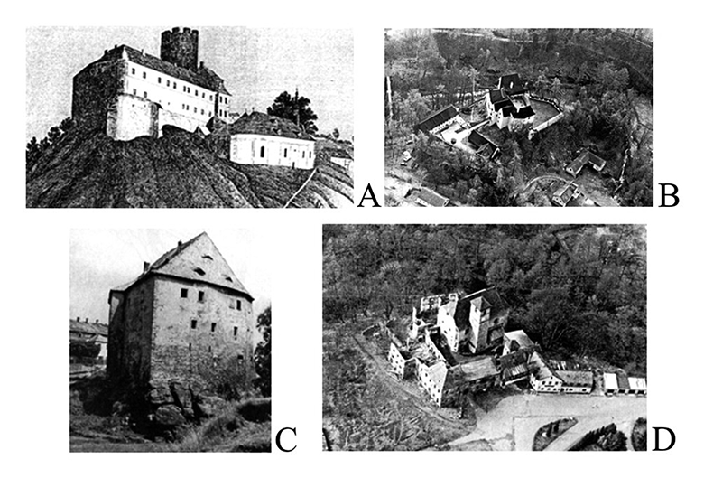
Fig. 9. The Castles Starý Hroznatov (A), Ostoh (B), Skalná (C), and Hazlov (D). Based on Durdík, 1999.
9 pav. Pilys Starý Hroznatov (A), Ostoh (B), Skalná (C) ir Hazlov (D). Pagal Durdík, 1999
The first high medieval castle built within the Bohemian territory was Přimda (Fig. 10), founded in the area of the Bohemia-Bavarian border forest by Diepold II from Vohburg as an attempt to breach and colonize the Bohemian domain. This castle, first mentioned in Cosmas’ Chronica Boemorum to have existed in 1121, was but an imported element of an already constituted high medieval castle. Therefore, Přimda represented the pinnacle of Romanesque architecture until Soběslav’s reconstruction of the Prague Castle in 1135 (Durdík, 2006a; 2007a; Sokol, 2015). Within Soběslav’s reconstruction (Durdík, 1999, p. 448), a new, wall-towered fortification was created using mortar-laid blocks, allegedly “according to Romanesque town walls,” to substitute previous timber-laced fortifications (Fig. 11). However, hillforts, or early medieval castles, still remained a leading type among fortified locations. Formed by these large early medieval fortified locations, an early medieval network of princely castles arose, referred to as the hradská soustava (“castellan organization”), the origins of which can be attributed to the reign of Boleslaus I (c. 915–972) or Boleslaus II (approx. 932–999). Undoubtedly, the organization is evidenced to have existed in the second third of the 11th century during the reign of Bretislav I (1002–1055) (e.g., Lutovský, 2001, p. 27, 41). The castles forming the organization were seen as the organizational and administrative pillars of the Přemyslid Bohemian as well as, from the first half of the 11th century, Moravian domains. The organization survived up until the 1230s, when it started to slowly crumble (Žemlička, 1997, p. 45–48; Durdík, 1999, p. 14; Lutovský, 2001, p. 90, including the overview of additional literature). Some of early medieval castles, such as Libice (Mařík, 2015a), also became seats of the noble Bohemian families, such as the Slavník dynasty related to the Dukes of Saxony, who later became Holy Roman Kings and Emperors (Mařík, 2006; 2009; 2015a, p. 186). At that time, we can observe some interesting cases of continuity or deliberate discontinuity. The examples can be found in two Western Bohemian early medieval hillforts lying opposite each other, Bezemín and Šipín (Fig. 12). The distance between them reaches 250 meters. Bezemín is the older one (Kudrnáč, 1951, p. 188–190; Lutovský, 2001, p. 20; Čtverák et al., 2003, p. 34–36; Mařík, 2015b) and was fortified with a timber-laced rampart, nowadays up to 2.5 meters tall and with a base width of 9 meters, with the fortification possibly being doubled at the access part. The acropolis was also protected with a timber-laced rampart, reinforced by a 1-meter-thick frontal stone revetment. There is also a 9-meter-wide and 1.5-meter-deep ditch and in front of the rampart. Archaeological finds allow us to place the site around the 8th and 9th centuries, after which the hillfort was destroyed by a catastrophic fire.
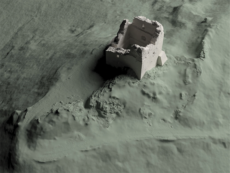
Fig. 10. Přimda. A 3D model of the Romanesque keep based on the LLS and ground scanning. Based on Sokol, 2015, p. 70.
10 pav. Přimda. Romaniškos pilies 3D modelis pagal lazerinio skenavimo iš oro (LLS) ir žemės paviršiaus skenavimo duomenis. Pagal Sokol, 2015, p. 70
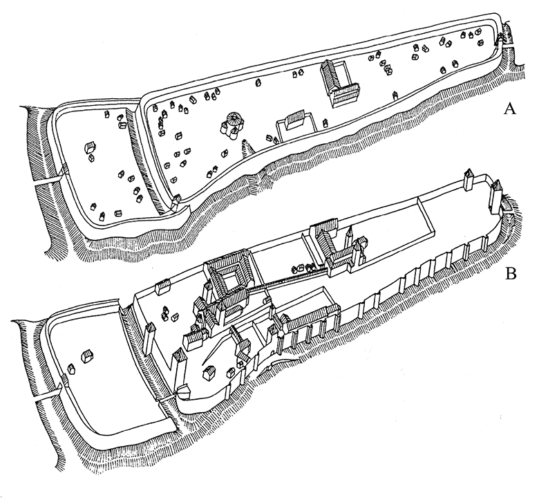
Fig. 11. The Prague Castle. A – a reconstruction of features from the late 10th century; B – a reconstruction of features from the late 12th century. Based on Durdík, 1999, p. 449.
11 pav. Prahos pilis. A – rekonstrukcija, X a. pabaiga; B – rekonstrukcija, XII a. pabaiga. Pagal Durdík, 1999, p. 449
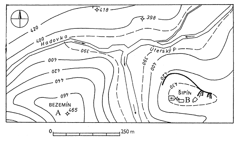
Fig. 12. The Bezemín Hillfort (A) and Šipín (B). Based on to Čtverák et al., 2003, p. 35, 308.
12 pav. Piliakalniai: Bezemín (A) ir Šipín (B). Pagal Čtverák et al., 2003, p. 35, 308
The Šipín Hillfort, separated from Bezemín by the Úterý River and reaching an overall size of 1.5 hectare, was located on the opposite promontory, which had been probably settled and fortified in the Bronze Age. The hillfort was provided with two lines of timber-lanced ramparts surrounded by a ditch from the outer side. The acropolis was then encircled by another pair of timer-lanced ramparts. The hillfort had probably been founded to replace an older site in the 9th century, and eventually survived until the 11th or even 12th centuries (Baštová, 1984, p. 498–504; Lutovský, 2001, p. 322; Čtverák et al., 2003, p. 308). The first high medieval administrative center in the region was the Gutštejn Castle (Hobl, 2015), located c. 700 meters from Šipín, which was built around 1300 in connection with division of property within the house of Hroznata. Therefore, Gutštejn did not serve as a seat replacing an older administrative one but as a base of power and colonization efforts for members of one of the most powerful contemporary noble families (Fig. 13).
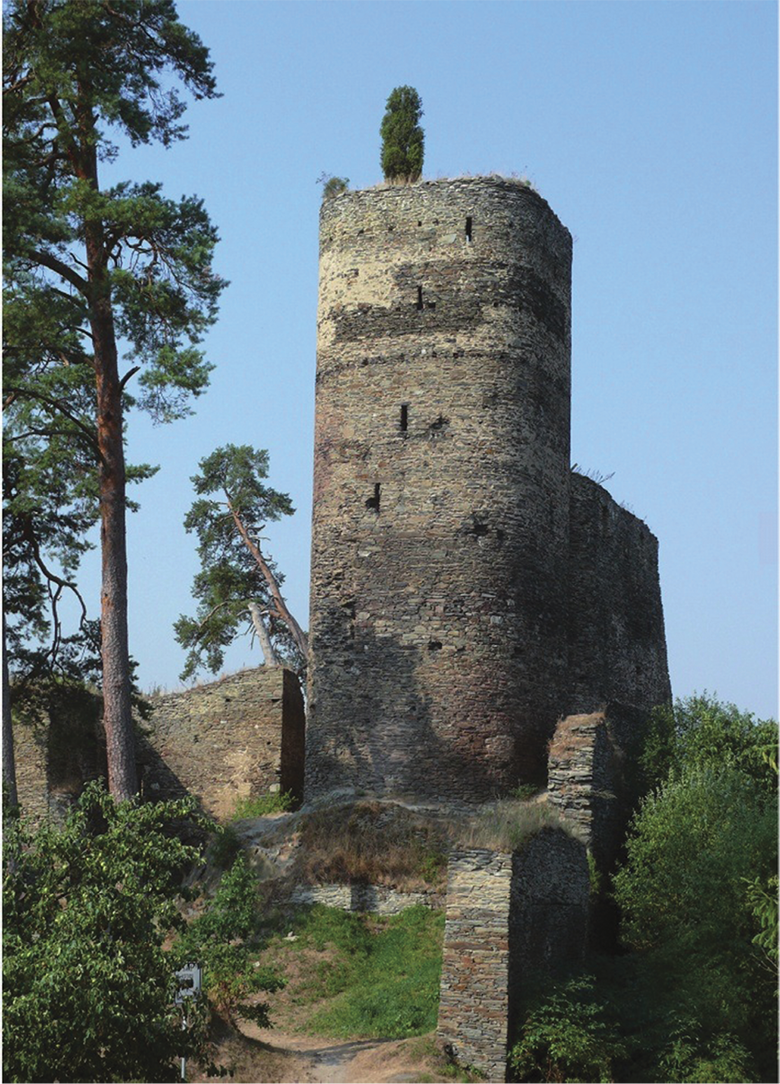
Fig. 13. The Gutštejn Castle. A view on tower from the east. According to Hobl, 2015, p. 132.
13 pav. Gutštejn pilis. Bokšto vaizdas iš rytų. Pagal Hobl, 2015, p. 132
In the first third of the 13th century, the first Romanesque castles, such as Blatná (for original form of the castle, see Durdík, 1985) and Landštejn (Durdík, Sušický, 2002, p. 63), were founded alongside the fading hillfort-based administrative system. Simultaneously with these stone castles, a full range of less advanced fortified features were founded, often standing between a castle and a manor house (for definitions, see, e.g., Piper, 1905, p. 589; Villena et al., 1975, p. 34–35; Kolektiv, 1977, p. 39, 87, 117, 118; Lutovský, 2001, p. 90; Böhme et al., 2004, p. 255–256; Gabriel, 2006, p. 14–20). Some of these sites fall into the category of transitional-type castles. The sites represent high medieval castles constructed with early medieval technologies, which was especially reflected in the construction of frontal walls in the form of more or less massive earthwork (Durdík, 2007b). A number of these castles and less advanced features served as colonization footholds (Hložek et al., 2013) and are also called “colonization makeshifts” (Wolf, 1998, p. 107–116).
In Bohemia, evidence of the continual use of strategically important locations from the Prehistory and Early Middle Ages until the High and Late Middle Ages can be observed in many cases. This continuity habitually results from similar demands put on the location of settlements in terms of the Early and the beginning of High Middle Ages’ settlement strategies. Both the climatic optimum and technological innovation brought by the medieval period (Klápště, 1994; 2012) also enabled the development of colonization activities in regions outside the old settlement area. The goal of new colonization activities was to settle regions with a less suitable climate, or regions of a lesser soil quality (for different regions, see more in Klír, 2008; 2010; Černá, Klír, 2014; Dudková et al., 2008, p. 63–64).
With the majority of the colonization efforts, the prospections focused on searching for new raw materials, especially iron, non-ferrous, and precious metals (Anderle, Švábek, 1989; Crkal et al., 2013; Gersdorfová et al., 2015), played a crucial role. From the 13th century, however, a new phenomenon arises; more attention was paid to the site’s wider strategic and economical potential. We may mention the connection of newly founded castles and cities to long-range routes (Durdík, 1998a), the stabilization of manufacturing and market circuits (Gabriel, 2000, p. 207), the administration of fiefs by prominent noble houses, and an attempt at strengthening the royal power that clashed with the rising economic potential of noble houses and medieval towns (see more in Durdík, 1995; Lavička et al., 2016).
However, in many cases, there was no straightforward continuity when a fortified area (castle, manor house) was founded in a dominant and morphologically well-protected location where an early medieval feature had once stood. An example can be found with the Maidštejn/Dívčí Kámen Castle (Fig. 14), which is composed of a castle and fortified urban castle surroundings (the lateranus), which is connected to the castle’s fortification (see more in Durdík, 2004; 2006c; Durdík, Sušický, 2002, p. 70–73; Hložek, 2016a). The lateranus was founded in the place of an older settlement, and a hillfort was built in the Earlier or Late Bronze Age. Both settlement horizons are separated by a settlement hiatus. Therefore, the promontory above the confluence of the Křemežský River (usually referred to as a stream) and the Vltava River was settled anew before the second half of the 14th century, when, based on the permission of Charles IV, the Rosenberg family built a large and still well-preserved castle of two-palace type in 1349 (for a typology of castles, see more in Durdík, 1999, p. 127). The inner bailey was formed by two palace wings joint by an enclosing wall.
Fig. 14. The Maidštejn/Dívčí Kámen Castle with its surroundings. Photo by L. Sváček.
14 pav. Maidštejn / Dívčí Kámen pilis ir jos aplinka. L. Sváček nuotrauka
The remnants of the Late Hallstatt and La Tène hillforts can also be found at the foreground of the castle of Orlík nad Vltavou built on a distinct promontory above the Vltava River, later reshaped by the Orlík Dam (Durdík, Kašička, Nechvátal, 1995, p. 22–34; Varhaník, 1998; Durdík, 1999, p. 403–405 with add. literature; Grabolle, Hrubý, Militký, 2002). The castle was built by King Otakar II of Bohemia by the end of his reign as a foothold of his power, and it was later held by Záviš of Falkenstein of the Vítkovci family during 1288–1289 and occupied by other noble houses ever since. The castle was founded in the northwestern part of an older and more extensive hillfort, which had also occupied the southwestern part of the promontory. Isolated finds allow dating the site back to the Late Hallstatt and Early La Tène periods (HD/LTA), when the fortification had probably been founded, and the following Early La Tène period (LT C-D) (Čtverák et al., 2003, p. 227 with add. literature; Kotýnek, 2016, p. 40). Similarly, features based on an older settlement were founded in Český Krumlov (Kotýnek, 2016, p. 32) or Tábor (Kotýnek, 2016, p. 43–44). However, the current state of knowledge does not allow us to evaluate whether both sites had been fortified in prehistory.
An example of continuity can be found in Zvíkov (Fig. 15 A, B), in the Písek district. The feature consists of a castle and a surrounding town-like settlement. The castle was founded as a crucial royal foothold possibly by Otakar I of Bohemia (Durdík, Sušický, 2002, p. 146–151) at a strategic location on a stretched steep promontory over the confluence of the Vltava and Otava Rivers. The castle was later significantly rebuilt by Otakar II. The oldest reference of the castle comes from 1234. After the extinction of the Přemyslid dynasty, the castle was pledged to the Rosemberg family until Charles IV obtained it and enlisted it into the Maiestas Carolina, according to which the castle was never to be suspended again. The original confluence of the Vltava and Otava Rivers with the portion of some older fortifications lies 80 meters under the water level today as a result of the Orlík Dam construction that took place during 1954–1961. The promontory was protected by steep slopes on its southern accessible side and was additionally secured by a quadruple rampart, from which two lines are still eminent today. The first rampart, complemented by a ditch, is cutting the promontory 240 meters south from the first gate. There is another rampart 60 meters away from this line, followed by a ditch after the next 60 meters (Fig. 16-A). A stone face is imminent in the rampart, possibly representing a dry-laid frontal stone revetment wall. The site had been fortified from the north, where a clay rampart, strengthened by a stone face on each side, was built over a trough cut into the bedrock. Its height reached at least 2 meters. The origin of settlement can be traced back to the Eneolithic. The fortification might have been founded at the end of the Earlier Bronze Age, and its existence is certain in the Late Bronze Age. The outer rampart of the southern fortification can be then related to the use of the site in the Late Hallstatt period. In the Late La Tène period, the Zvíkov fortification represented a part of hillfort chain along the Vltava River. It is therefore sometimes considered an oppidum, but it was merely a smaller strategic foothold referred to as a castellum. Even though the northern fortification exhibits elements similar to the northern one, it is not possible to exclude its connection to the castle’s siege in the end of the 1430s (Čtverák et al., 2003, p. 356–357 with add. literature). Leastwise, these ramparts and ditches could have played a certain role in this conflict or during the Thirty Years’ War approximately two centuries later. The fortified Zvíkov surroundings, accessible by a pair of gates, with the Church of St. Nicolas and a mill, are nowadays located deep under the Orlík’s water level (Durdík, Sušický, 2002, p. 149, Fig. LI). During the drought periods, the upper parts of the Zvíkov surroundings become accessible and bring evidence of other prehistoric use of the area. With its construction form, the 13th century royal castle represents one of the finest and best preserved examples of a castle with a perimeter development (for this type, see more in Durdík, 1999, p. 198).
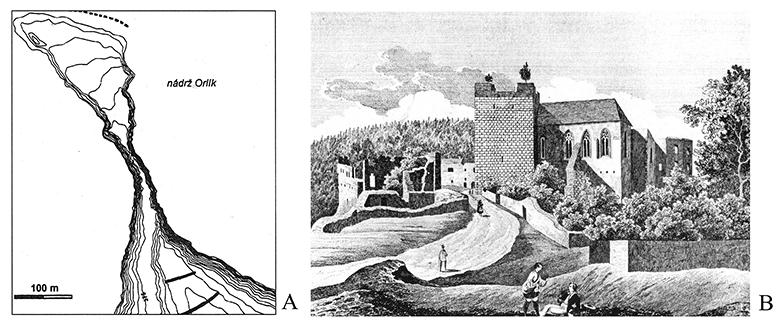
Fig. 15. The Zvíkov Castle. A – Zvíkov’s surroundings. Promontory terrain without the castle’s developments, with the older rampart’s fortification highlighted. Based on Čtverák et al., 2003, p. 357. B – the Zvíkov Castle in the 1840s in J. Fark’s engraving based on F. A. Heber’s work. Based on Durdík, 1999, p. 633.
15 pav. Zvíkov pilis. A – Zvíkov apylinkės. Iškyšulys be pilies su buvusiais įtvirtinimais – pylimais. Pagal Čtverák et al., 2003, p. 357. B – Zvíkov pilis apie 1840-uosius, iš J. Fark raižinio pagal F. A. Heber darbą. Pagal Durdík, 1999, p. 633
Another possible variant of the relationship between an older fortified settlement and a medieval castle is a partial relocation of an older center to a feature founded elsewhere. An example can be found at the royal castle of Velešín (Fig. 16), added by a town founded on a platform edge at the opposite slope of the Malše River, the valley of which was significantly changed during the foundation of the Římov Dam in 1971–1978. The oldest mention of the castle’s possible existence is a Čéče of Velešín predicate from 1266 (Durdík, 2008, p. 12–14; for an interpretation of local property rights, see Lavička et al., 2016, p. 297–300). However, archaeological finds allow dating the site back to the 1330s (Durdík, 2002a; 2008, p. 25–27; Durdík, Hložek, 2016, p. 207; Hložek, 2016b). This fact would enable to connect the origins of the castle to the strengthening of the footholds at the end of Otakar’s, or at the beginning of Wenceslas’s, rule in Bohemia (Durdík, 1999, p. 40). The reason of founding such an extensive, and in the earlier periods probably enlarged, castle (Durdík, Hložek, 2016, p. 218) could be a substitution for an original but still surviving administrative center in form of the Doudleby Hillfort (Dubský, 1949, p. 542–553; Čtverák et al., 2003, p. 75–76; Lavička et al., 2016, p. 279), (Fig. 17). The promontory itself was probably used in the Earlier Bronze Age and Iron Age. For the time being, it is not certain, especially when considering the large earthwork connected to the castle’s construction, whether the site had been already settled in prehistory. The construction form of the castle’s core may be seen in the context of developed bergfrit-type castles (Durdík, 1999, p. 56–58). The castle was dominated by two round towers, one of which was based in the castle’s front and contained residential premises equipped by a privy in the highest floor, shaft of which was built within the thickness of the wall. There was also an extensive, right-angled palace with the adjacent second tower in the central part of the castle’s core.
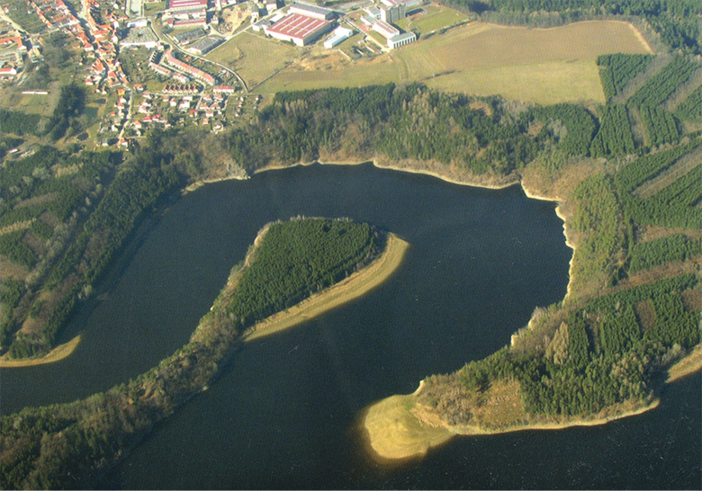
Fig. 16. The Velešín Castle. The overall promontory situation before the construction of the Římov Dam. Based on Durdík, 2008.
16 pav. Velešín pilis. Iškyšulys prieš pastatant Římov užtvanką. Pagal Durdík, 2008
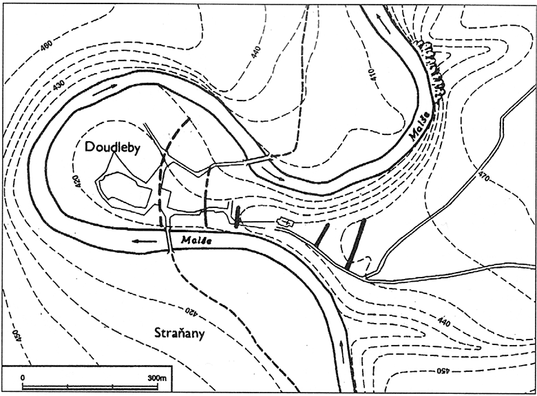
Fig, 17. The Doudleby Hillfort. A schematic plan of the hillfort with the preserved and supposed fortifications highlighted. Based on Čtverák et al., 2003, p. 75.
17 pav. Doudleby piliakalnis. Išlikusių ir spėjamų piliakalnio įtvirtinimų schema. Pagal Čtverák et al., 2003, p. 75
An example of a direct transformation of an Early Medieval hillfort into a high medieval castle is represented by the long-used and repeatedly fortified promontory in the southern part of the city of Bechyně (Fig. 18), over the right bank of the Lužnice River. The development of the castle was greatly influenced by an older layout, when the castle was a hilltop settlement populated in prehistory and the Early Middle Ages. So far, settlement activities have been evidenced and dated back to the turn of the Earlier and Middle Bronze Ages, when the Věteřov settlement was founded here, probably already fortified. The settlement of this strategically significant location then continued in the La Tène period (Beneš, 1975; Militký, 1993; Čtverák et al., 2003, p. 31–32; Krajíc, 2007, p. 139; Kotýnek, 2016, p. 30). In the Early Middle Ages, the location was occupied by a significant Přemyslid hillfort with the Church of St. George (Muk, 1979), which stood at the outer bailey until 1814. The existence of the hillfort is supported by written sources. During the 11th and 12th century, Bechyně was an important Přemyslid administrative center, which eventually came into the possession of the Bishopric of Prague. In 1268, Bechyně was acquired by Otakar II, possibly together with other surrounding lands (Menclová, 1972/II, p. 329–331; Drda, Tecl, 1978, p. 758); the ruler built a castle that came into the possession of noble families in the 14th century. Unfortunately, there are only remnants left of the original Otakar’s castle, such as parts of the main wall incorporated in today’s western palace wing. Despite the incomplete state of knowledge of the original castle, it can be assumed that the castle represented a castle with a perimeter development type (see more in Durdík, 1999, p. 198). The late Gothic conversion then transformed Bechyně into both a comfortable residence and a mighty stronghold secured by a massive shield wall and a new front fortification with polygonal bastions. An older rampart, possibly of a hillfort-period origin, was also reshaped, equipped with a shooting gallery, and was therefore a valuable part of the castle’s access defences (Durdík, 1999, p. 55; 2002b, p. 11).
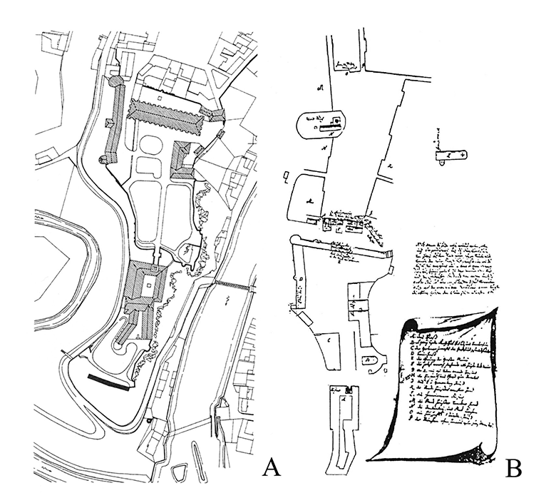
Fig. 18. The Castle and Palace of Bechyně (A). According to Durdík, 1995, p. 55; B – the castle’s floor plan with the Church of St. Jiří (1724–1776). Based on Durdík, 2002, p. 11.
18 pav. Pilis ir rūmai Bechyně (A). Pagal Durdík, 1995, p. 55; B – pilies planas ir Šv. Jurgio (1724–1776) bažnyčia. Pagal Durdík, 2002, p. 11
An early medieval Přemyslid administrative hillfort founded on a rocky promontory protected by the Nežárka River and the surrounding wetlands was also a predecessor to one of the oldest royal castles in Bohemia – Jindřichův Hradec (Fig. 19), first mentioned in 1220. Soon after its foundation, the castle became a seat of one of the Vítkovci family cadet branches – the Hradec family. During an archaeological excavation conducted by T. Durdík in the 1970s and 1980s, the course of the oldest fortification was unearthed, formed by a timber-laced rampart and strengthened by a frontal stone revetment wall. The overall area of the castle was later reduced by embedding a ditch into the bedrock. Both fortifications enclosed the general area of the hillfort. The royal castle secured the position of the late acropolis. The royal city and the castle’s surroundings were also founded on the site of previous outer bailey. Although the origins of the hillfort may date back to the 9th century, its foundation in the second half of the 10th or 11th centuries seems more likely (Durdík, Čečelín, 1987; Durdík, 1988; 1992; Čtverák et al., 2003, p. 227 with add. literature). The considerable extent of the castle was largely predetermined by the size of the old hillfort’s acropolis. Based on the knowledge about the castle’s shape in the 13th century, when the minimalistic inner development of the castle contrasts with the massive fortification, it is possible to presume that the expansion of this castle with its perimeter development (see more in Durdík, 1999, p. 198) was never realized to its full extent. This assumption is supported by the fact that the unfinished royal castle was acquired by the Vítkovci family, who finalized its development according to their economic possibilities and needs.
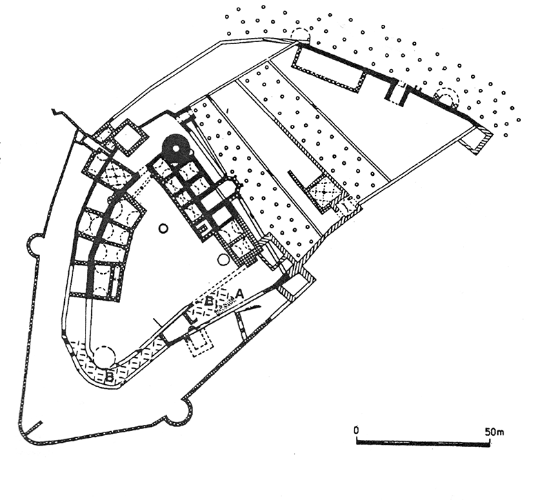
Fig. 19. The Jindřichův Hradec Castle. The castle’s plan depicting the remnants of the Slav hillfort fortifications. A – the early medieval walls; B – a ditch from the early period of the hillfort. Based on Čtverák et al., 2003, p. 119.
19 pav. Jindřichův Hradec pilis. Pilies planas su slavų piliakalnio įtvirtinimais. A – ankstyvųjų viduramžių mūrinės sienos; B – ankstyvojo piliakalnio laikotarpio gynybinis griovys. Pagal Čtverák et al., 2003, p. 119
An early medieval hillfort had also been founded in a location where the castle of Prácheň (Fig. 20) was later built. Preceding the medieval castle lying on the current border of Western and Southern Bohemia was a Přemyslid hillfort administrating the Prácheň province (Lutovský, 2001, 336–337). The two-part hillfort reaching a size of 2.8 ha was, especially at the acropolis, protected by steep slopes. Only the eastern part of the fortification enclosing the outer bailey has been preserved. The rampart reaches a width of 15 meters and a height of approx. 6 meters, while the original timber-laced wall reaches a width of 5.5 meters. The front of the wall was reinforced with a frontal stone revetment. There is also a shallow ditch adjacent to the wall from the outer side. The hillfort is evidenced by written sources in the first half of the 11th century. Due to administration’s transfer to the newly-founded city of Horažďovice in the 13th century, the hillfort was slowly wearing off, and its remnants can be presumed under the Church of St. Clement. The hill was, possibly with the then-defunct hillfort, given to Bavor III of Strakonice by king John of Bohemia in order to build a castle there, which then stayed in the noble house’s possession until the end of the 15th century. As in other cases of John’s castle-building policy, it seems that the reason for this step was to entrust Bavor with building a castle appropriate to the dimensions of a large royal castle, which was supposed to be given to him as a fief later under the condition that the castle will be always available for a king. This may not only be the reason for such a great extent of the castle, but also for the fact that the castle can be, according to its form, put into the context of royal castles with perimeter developments (see more in Durdík, 1999, p. 198). The extended castle area was separated into three parts. In the frontal part, which possibly held a defensive role, there are no signs of any inner development. The frontal area of the middle part of the castle was dominated by a round bergfrit tower with a gate in its vicinity. There were palace wings along the wall from the inner side, with the outer side being strengthened with four small flanking towers. The application of features possibly capable of active defence can be considered a reaction to the principles of the French castell type, which was introduced in Bohemia in the 13th century, representing one of the major imports within castle architecture. With regard to flanking towers’ orientation toward the city of Horaždovice, there might have been a certain symbolic and demonstrative cause to this fortification feature (for more on demonstrative architecture, see Durdík, 2006b). In the course of the first half of the 13th century, the French castells became, together with castles with perimeter developments and transitional-type castles, representatives of one of the oldest castle types in Bohemia (for more regarding the wider European context, see Durdík, 1989; 1994; 2007). The rear part of the castle disposition was filled by development of the economic character arranged along the perimeter wall and possibly by another tower of an unclear floor plan. Based on historical building research, there is another possible interpretation. A part of the preserved transverse wall dividing the middle and northern part of the castle seems to be unfinished. Therefore, there is a possibility that when the hill where the castle had supposed to be built was given to Bavor III by King John in 1315, the site may not have been completely deserted, with only some possible remnants of the older hillfort. An older, either deserted or devastated, royal castle may have stood there, which was then only rebuilt by Bavor. This possible interpretation may be supported by a rather anachronistic form of the castle, seemingly belonging to the half of the 13th century (Laval, Razím, 2006, p. 192–193). However, the choice of such an out-of-date solution may have had its reason even if the castle had been founded by Bavor himself due to its demonstrative significance, as similar cases are documented with the foundation of Karlštejn and Hrádek u Purkarce/Karlhaus by Charles IV; the form of both castles is linked to the older Přemyslid development tradition.
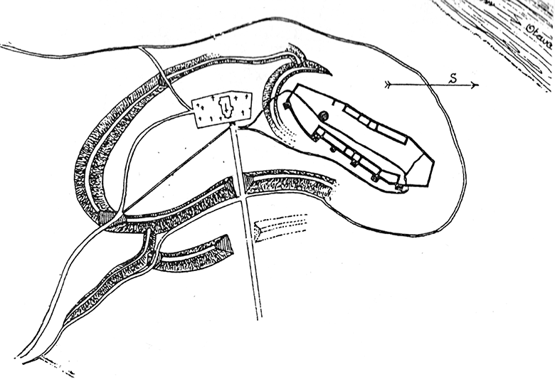
Fig. 20. The Prácheň Castle. Floor plan of the early medieval hillfort and medieval castle. Based on Čtverák et al., 2003, p. 337.
20 pav. 20. Prácheň pilis. Ankstyvųjų viduramžių įtvirtinto piliakalnio ir viduramžių pilies planas. Pagal Čtverák et al., 2003, p. 337
The castle of Týnec nad Sázavou (Fig. 21) has also undergone a no less complicated development. The castle was built near an important path connecting the central and southern Bohemian areas over the Otava River ford (Záruba, 2016, p. 101). The castle promontory was settled in the Hallstatt and Early La Tène, when a smaller feature originated in a form of smaller hillfort or farmstead (Čtverák et al., 2003, p. 329). The first pieces of evidence of the castle’s existence come from the beginning of the 14th century as a property of Oldřich of Týnec. However, early medieval settlement can be traced back to the second half of the 11th century. Soon after, a rotunda of unknown consecration was founded, surrounded by a residential, stakehole-based building from the north and west, and a graveyard from the south. The overall extension of the settlement has not been surveyed. Therefore, it is not clear whether there was just an unfortified agglomeration, an older hillfort, or a lightly fortified farmstead based on prehistoric settlement. Supporting the existence of a farmstead is the name “Týnec” itself, which could be, based on the word’s morphology, related to a lightly fortified feature similar to a farmstead. Moreover, the dating of the timber-lanced rampart situated in front of the Romanesque palace also remains inconclusive (for more on this interpretation, see Hejna, 1977, p. 131; 1983, p. 399; Durdík, 2007, p. 159). The castle was rebuilt around 1200, when a prismatic tower was added to the older rotunda together with a palace adjacent to the complex from the north. After a certain time, a circumferential ditch was built together with a rampart, demarcating the castle’s area of approximately 0.17 hectare (for a further interpretation, see Záruba, 2016, p. 101–109). In the following phases, a new stone fortification, supplemented by bastions, was founded with some more development. Also, the palace underwent several adjustments later. The first phase of Týnec nad Sázavou can be therefore considered as a transitional-type castle.
Fig. 21. The Týnec nad Sázavou Castle. Eastern view of the castle. Based on Záruba, 2016, p. 104.
21 pav. Týnec nad Sázavou pilis. Vaizdas iš rytų. Pagal Záruba, 2016, p. 104
Conclusion
Continuous settlement and the further use of others, especially hilltop and strategically significant locations from prehistory, is a phenomenon that can be seen throughout the whole Bohemian and European area. This continuity is usually based on rather similar demands put on the location of (especially) fortified settlements of various characters. Primarily from the 13th century, fortified features of a different character and construction quality were also founded on the account of colonization activities directed outside the old settlement area. The crucial factor of the reconstruction of possible reasons for founding various fortified areas in prehistory and the Early and High Middle Ages is the analysis of the settlement and geographic contexts of individual features in accordance with an evaluation of both preserved written sources (if they are preserved at all) and archaeological evidence. Based on this assessment, many features are to be interpreted not only as colonization footholds but as, e.g., strongholds connected to disputed lands. A number of unfinished castles then illustrate the unrealized colonisation efforts or the process of raising the domains of noble houses. In terms of the process of the “privatization” of Bohemian lands, the overall picture of Přemyslid and Luxembourg castle policy seems crucial, as its main goal was not only to create a network of strongholds enabling the rulers direct control over the land but also to set out a balance between the royal intensions and rising ambition of the leading noble houses, especially the Southern Bohemian Vítkovci family.
Literature
Anderle J., Švábek V. 1989. Hrady na Strašicku – pokus o rekonstrukci jejich postavení v životě oblasti před polovinou 14. století. Castellologica bohemica, 1, p. 105–123.
Baštová D. 1984. Šipín a Všeruby – nové hradištní nálezy v Plzeňska. Archeologické rozhledy, 36, p. 498–511.
Beneš A. 1975. Bechyně. Objev nového pravěkého hradiště. Výběr, 12, p. 283.
Böhme H. W., Friedrich R., Schock-Werner B. 2004. Wörterbuch der Burgen Schlösser und Festungen. Stuttgart: Reclam, Philipp, jun. GmbH, Verlag.
Břeň J. 1966. Třísov – keltské oppidum. Praha: Národní muzeum v Praze.
Břeň J. 1967. Keltské oppidum Třísov. Archeologické rozhledy, 19, p. 605–611.
Břeň J. 1971. Das keltische Oppidum in Třísov. Archeologické rozhledy, 23, p. 294–303.
Břeň J. 1975. Zvláštní typ sídlištních objektů na keltském oppidu v Třísově u Českého Krumlova. Časopis Národního muzea v Praze, 144, p. 119–136.
Crkal J., Konůpek J., Kovařík D., Prekop F., Staňková D., Volf M. 2013. Osídlení a utváření krušnohorské krajiny. Proměny montánní krajiny. T. Karel, A. Kratochvílová (eds.) Historické sídelní a montánní struktury Krušnohoří. Loket: NPÚ, p. 11–13.
Černá E., Klír T. 2014. Osídlení Krušných hor v mladším středověku a raném novověku: kontext a cíle interdisciplinárního výzkumu. I. Boháčová, P. Sommer (eds.) Středověká Evropa v pohybu: k poctě Jana Klápště. Praha: ARÚ AVČR Praha, p. 105–118.
Čtverák V., Lutovský M., Slabina, M., Smejtek L. 2003. Encyklopedie hradišť v Čechách. Praha: Libri.
Drda M. 1987. Keltské oppidum Hrad u Nevězic. Archeologické rozhledy, 39, p. 517–556.
Drda M., Tecl R. 1978. K předhusitskému osídlení Tábora. Český časopis historický, 26, p. 740–764.
Dreslerová D., Hrubý P. 2004. Halštatské výšinné lokality v jižních Čechách – nové výzkumy dvou hradišť. Študijné Zvesti, 36, p. 105–129.
Dubský B. 1949. Pravěk jižních Čech. Blatná: Bratři Římsové.
Dudková V., Orna, J., Vařeka, P. 2008. Hledání zmizelého. Archeologie zaniklých vesnic na Plzeňsku. Plzeň: ZČM v Plzni.
Durdík T. 1985. K počátkům a středověké stavební podobě hradu v Blatné. Archaeologia historica, 10, p. 283–295.
Durdík T. 1988. Deset let archeologického výzkumu hradu v Jindřichově Hradci (1975–1986). Zpravodaj oboru památkové péče, 1988/B-1, p. 1–86.
Durdík T. 1989. K původu kastelů středoevropského typu. Archaeologia historica, 14, p. 233–255.
Durdík T. 1992. Středověký vývoj. Jindřichův Hradec 1293/1993. České Budějovice, p. 69–83.
Durdík T. 1994. Kastellburgen des 13. Jahrhunderts in Mitteleuropa. Böhlau. Wien–Köln–Weimar: Böhlau.
Durdík T. 1995. Královské hrady a královská města v Čechách 13. století. Archaeologia historica, 20, p. 331–337.
Durdík T. 1998a. Několik poznámek ke vztahu českých hradů ke komunikacím a jejich komunikačnímu schématu. Archaeologia historica, 23, p. 203–213.
Durdík T. 1998b. Hrady kastelového typu 13. století ve střední Evropě. Praha. Academia.
Durdík T. 1999. Ilustrovaná encyklopedie českých hradů. Praha: Academia.
Durdík T. 2002a. Velká věž hradu Velešína. Castellologica bohemica, 8, p. 409–416.
Durdík T. 2002b. Ilustrovaná encyklopedie českých hradů. Dodatky. Praha: Academia.
Durdík, T. 2004: Hrad Dívčí Kámen (Maidštejn, Menštejn) Dívčí Kámen. Přírodní rezervace a historický vývoj osídlení. Křemže: obec Křemže, p. 62–70.
Durdík T. 2006a. Přimda – die älteste Steinburg in Böhmen. Forschungen zu Burgen und Schlösser, 9, p. 95–103.
Durdík T. 2006b. Zur Frage der demonstrativen Architektur der böhmischen Burgen. Castrum Bene, 8, p. 3–17.
Durdík T. 2006c. Latran – ein spezifischer Typ der befestigten Unterburgsiedlungen in Böhmen. Château Gaillard, 22, p. 109–118.
Durdík T. 2007a: Hrad Přimda. Vlastivědná knihovnička Společnosti přátel starožitností 14. Praha: Společnost přátel starožitností.
Durdík T. 2007b: Hrady přechodného typu. Praha: Agentura Pankrác.
Durdík T. 2008: Hrady na Malši. Vlastivědná knihovnička Společnosti přátel starožitností 15. Praha: Unicornis.
Durdík T., Sušický V. 2002. Zříceniny hradů, tvrzí a zámků. Jižní Čechy. Praha: Agentura Pankrác.
Durdík T., Čečelín V. 1987. Cíl a výsledky geofyzikálního výzkumu v areálu hradu v Jindřichově Hradci. Archeológia – geofyzika – archeometria. Nitra: ARÚ Nitra, p. 90–96.
Durdík T., Hložek J. 2016. Předstihový výzkum na hradě Velešíně v roce 2011. Castellologica bohemica, 13, p. 207–220.
Durdík T., Sušický V. 2002. Zříceniny hradů, tvrzí a zámků. Jižní Čechy. Praha: Agentura Pankrác.
Durdík T., Kašička F., Nechvátal B. 1995. Hrady, hrádky a tvrze na Písecku. Písek: Prácheňské muzeum v Písku.
Fröhlich J., Eigner J. 2010, Nově objevená eneolitická výšinná sídliště v oblasti Orlické přehrady. Příspěvek k eneolitickému osídlení podél středního toku Vltavy. Archeologie ve středních Čechách, 14, p. 29–49.
Fröhlich J., Lutovský M., Michálek J. 2004. Raně středověké osídlení Blanice na Vodňansku a Protivínsku. Archeologické výzkumy v jižních Čechách, 17, p. 207–229.
Gabriel F. 2000. Vesnice, hrad a město v severních Čechách. Archaeologia historica, 25, p. 205–213.
Gabriel F. 2006. Teoretické aspekty studia hradních staveb. Ústí nad Labem: Univerzita J. E. Purkyně.
Gersdorfová Z., Hložek J., Menšík P., Procházka M. 2015. Dva opevněné objekty u Bernartic (okres Písek): k otázce jejich vztahu, funkční interpretace a souvislostí. Archaeologia historica, 40/2, p. 493–505.
Grabolle R., Hrubý P., Militký J. 2002. Orlík nad Vltavou ve 13.–14. století ve světle archeologického výzkumu. Archaeologia historica, 27, 91–118.
Hájek L. 1954. Jižní Čechy ve starší době bronzové. Památky archeologické, 45, p. 115–192.
Havlice J., Hrubý P. 2002. Betrachtung über die Burgwälle und Höhensiedlungen am Ende der Frühbronzezeit in Südböhmen. Archäologische Arbeitsgemeinschaft Ostbayern/ West- und Südböhmen, 11. Treffen 20. – 23. 6. 2001 in Obernzell. Rahden/Westf., p. 42–61.
Hejna A. 1977. Výsledky archeologického výzkumu v areálu v Týnci nad Sázavou. Sborník vlastivědných prací z Podblanicka, 18, p. 129–140.
Hejna A. 1983. Příspěvek ke studiu malých opevněných sídel doby přemyslovské v Čechách. Památky archeologické, 74, p. 366–436.
Hlásek D., Chvojka O., Šálková T., Fröhlich J., Houfková P., Kovačiková L., Majer A., Menšík P., Michálek J., Netolický P., Novák J., Pavelka J., Petřík J., Sosna D. 2015. Vrcovice. Hradiště z počátku střední doby bronzové, Archeologické výzkumy v jižních Čechách – Supplementum 10. České Budějovice: Jihočeské muzeum v Českých Budějovicích.
Hložek J. 2016a. Několik poznámek k podhradním aglomeracím v jižních Čechách – tzv. Latránům. Jihočeský sborník historický – Supplementum, 7, p. 295–313.
Hložek J. 2016b. K možnostem interpretace stavebního vývoje kaple hradu Velešín, okr. Český Krumlov, Castellologica bohemica, 16, p. 215–236.
Hložek J., Baierl P., Kasl F., Menšík P., Procházka M. 2013. Liškův hrad, okr. Plzeň-jih. Nové geodetické zaměření lokality a její hodnocení v kontextu soudobé hradní produkce. Archaeologia historica, 38/2, p. 399–414.
Hobl L. 2015. Věž hradu Gutštejna z pohledu archeologie. Castellologica bohemica, 15, p. 130–139.
Hrubý P. 1998. Výšinné lokality pozdní doby halštatské a časné doby laténské v jižních Čechách. Zprávy České archeologické společnosti – Supplément 34. Praha: Česká archeologická společnost.
Hrubý P., Chvojka O. 2002, Výšinné lokality mladší a pozdní doby bronzové v jižních Čechách. Archeologické rozhledy, 54, p. 582–624.
Hrubý P., Lutovský M. 2000. Hradiště a výšinné sídliště raného středověku v jižních Čechách. Archeologie ve středních Čechách, 4/2, p. 439–483.
Chroustovský L. 2015. On the memory of sacred mountains of Bohemian prehistory. Gedigi B., Grossman A., Piotrowskiego W. (eds.) Miejsca pamięci pradzieje, Średniowiecze i I Współczesność. Biskupin – Wrocław: Muzeum Archeologiczne w Biskupinie – Polska Akademia Nauk, p. 257–271.
Chvojka O. 2007. Současný stav poznání doby bronzové v jižních Čechách. Archeologie na pomezí. Sborník příspěvků ze semináře. České Budějovice, 8. 11. 2007. Archeologické výzkumy v jižních Čechách – Supplementum 4. České Budějovice: Jihočeské muzeum v Českých Budějovicích, p. 29–55.
Chvojka O. 2009. Jižní Čechy v mladší a pozdní době bronzové. Disertationes Archaeologicae Brunenses Pragensesque, 6, Brno: MU v Brně.
Chvojka O. 2015. Současný stav poznání pozdní doby bronzové v jižních Čechách. Studia Hercynia, 19/1–2, p. 111–121.
Chvojka O., John J., Menšík P. 2012. Neue Erkenntnisse zu den vor- und frühgeschichtlichen Burgwällen in Südböhemn. Fines Transire, 21, p. 85–102.
Chvojka O., John J., Janovský M., Michálek J. 2013. Pravěké hradiště u Skočic (okr. Strakonice). Archeologické výzkumy v jižních Čechách, 26, p. 25–76.
John J., Eigner J., Fröhlich J., Šálková T. 2012. Výšinné sídliště u Velké a další nové poznatky o eneolitických výšinných lokalitách na střední Vltavě. Archeologické výzkumy v jižních Čechách, 25, p. 63–81.
Karel T., Knoll V. 2016. Hrady na Chebsku jako reprezentanti moci. Castellologica bohemika, 16, p. 153–178.
Klápště J. 1994. Změna. Středověká transformace a její předpoklady. Památky archeologické – Supplementum, 2, p. 9–59.
Klápště J. 2012. Proměna českých zemí ve středověku. Praha. Academia.
Klír T. 2008. Osídlení zemědělsky marginálních půd v mladším středověku a raném novověku. Dissertationes Brunenses /Pragensesque, 5, Praha–Brno: UK v Praze.
Klír T. 2010. Osídlení horských oblastí Čech ve středověku a raném novověku – východiska interdisciplinárního výzkumu. Archaeologia historica, 35, p. 373–391.
Knoll V. 2003. Štaufští ministeriálové a Sedlecko. Poznámka k počátkům loketského manského systému a loketské krajské správy. Západočeský historický sborník, 8, p. 7–27.
Knoll V., Karel T. 2012. Burgen im Land zwischen Böhmen und Reich. Der gegenwärtige Erkenntnisstand zum älteren Horizont der Adelssitze im Egerland. Birngruber K., Christina Schmidt Ch., Herwig Weigl H. (Hrsg.) Adel, Burg und Herrschaft an der „Grenze“: Österreich und Böhmen. Beiträge der interdisziplinären und grenzüberschreitenden Tagung im Freistadt, Oberösterreich, 26. bis 28. Mai 2011. Studien zur Kulturgeschichte von Oberösterreich Folge, 34. Linz: Oberösterrechisches Landesmuseum, p. 205–219.
Kolektiv 1977: GLOSSARIUM ARTIS. Deutsch – Französisches – Werterbuch zur Kunst. Tübungen–Strasbourg–München: Tübingen.
Kotýnek M. 2016. Osídlení výšinných poloh ve střední až pozdní době laténské. Archeologie západních Čech, 11, p. 28–65.
Krajíc R. 2007. Bechyně – Táborská ulice. Archeologický výzkum v roce 2006. Archeologické výzkumy v jižních Čechách, 20, p. 133–165.
Kudrnáč V. 1951. Slované v západních Čechách. Archeologické rozhledy, 3, p. 185–190.
Laval F., Razím V. 2006. Příspěvek k diskusi o vývoji raně středověkých opevnění ve 12. a 13. století. Archaeologia historica, 31, p. 181–197, 192–193.
Lavička R., Čapek L., Fröhlich J., Havlice J., Krajíc R., Reitinger L. 2016. Královská založení na jihu Čech za vlády posledních Přemyslovců. České Budějovice: NPÚ.
Lutovský M. 1999. Odraz mocenských změn 10. století ve struktuře jihočeských hradišť. Archeologie ve středních Čechách, 3, p. 293–291.
Lutovský M. 2000. Jihočeská hradiště v 10. století. K problematice přemyslovskému záboru jižních Čech, Přemyslovský stát kolem roku 1000. Na paměť knížete Boleslava II. (7. února 999). Praha: Lidové noviny, p. 174–178.
Lutovský M. 2001. Encyklopedie slovanské archeologie v Čechách, na Moravě a ve Slezsku. Praha: Libri.
Lutovský M. 2011. Jižní Čechy v raném středověku. Slovanské osídlení mezi Práchní a Chýnovem. České Budějovice: Veduta.
Lutovský M., Michálek, J. 2002. Archeologie knížecího sídla. Praha: Set Out.
Lutovský M., Michálek J. 2007. Die südböhmischen Burgwälle im 9. Und 10. Jahrhundert. Bemerkungen zu Struktur, Chronologie und historischen Zusammenhängen. Archäologische Arbeitsgemeinschaft Ostbayern/West- und Südböhmen, 16. Treffen, 21. Bis 24. Juni 2006 in Plzeň-Křimice. Rahden/Westf, p. 255–265.
Mařík J. 2006. Libická sídelní aglomerace ve výpovědi archeologických pramenů Die Siedlungsagglomeration Libice (Libitz) im Licht der archäologischen Quellen. Cuthna Antiqua, 2, p. 42–56.
Mařík J. 2009. Libická sídelní aglomerace a její zázemí v raném středověku. Dissertationes archaeologicae Brunenses/Pragensesque, 7. Praha: UK Praha.
Mařík J. 2015a. Bezemín okr. Tachov, Plzeňský kraj. Raně středověké hradiště a mohylník. Kuna M. a kol. Archeologický atlas Čech. Vybrané památky od pravěku do 20. století. Praha: ARÚ AVČR – Academia, p. 50–52.
Mařík J. 2015b. Libice nad Cidlinou okr. Nymburk, Středočeský kraj. Raně středověké hradiště. Kuna M. a kol. Archeologický atlas Čech. Vybrané památky od pravěku do 20. století. Praha: ARÚ AVČR – Academia, p. 186–190.
Menclová D. 1972. České hrady II. Praha: Odeon.
Menšík P., Král V. 2017. „Kněží hora“ u Katovic. Raně středověká pevnost nad řekou Otavou z pohledu archeologického bádání. Strakonice: Muzeum středního Pootaví Strakonice – městys Katovice.
Menšík P., Plzák J. 2018. Grodzisko „Kněží hora“ koło Katovic (region południowych Czech) w świetle lotniczego skaningu laserowego. Gojda M. – Kobyliński Z. (red.) Lotnicze skanowanie laserowe jako narzędzie archeologie. Archaeologica Hereditas, 11. Warszawa: Fundacja Res Publica Multietnika, p. 279–288.
Menšík P., Procházka M., Král V. v tisku: Der frühmittelalterliche Burgwall „Kněží hora“ bei Katovice (Bezirk Strakonice/CZ). Ein übergemeinschaftliches Zentrum mit Hinweisen auf „fremde“ Kontakte, Fines Transire.
Michálek J. 2007. K současnému stavu výzkumu doby železné v jižních Čechách. Archeologie na pomezí. Sborník příspěvků ze semináře. České Budějovice, 8. 11. 2007. Archeologické výzkumy v jižních Čechách – Supplementum 4. České Budějovice, p. 57–78.
Michálek J., Lutovský M. 2000. Hradec u Němětic. Sídlo halštatské a raně středověké nobility v česko-bavorském kontaktním prostoru. Strakonice – Praha: ÚAPPSČ.
Michálek J., Pavlů I., Vencl S., Zápotocká M. 2000. Nová neolitická sídliště (LnK a StK) a žárový hrob (StK) v Radčicích, okr. Strakonice, v jižních Čechách. Památky archeologické – Supplementum, 13, p. 266–302.
Militký J. 1993. Pravěká a raně středověká hradiště Bechyně. Výběr, 30, p. 95–98.
Muk J. ml. 1979. Chrám sv. Jiří a gotický špýchar hradu Bechyně. Archaeologia historica, 4, p. 113–117.
Neustupný E. 1995. The significance of facts. Journal of European Archaeology, 3.1, p. 189–212. https://doi.org/10.1179/096576695800688250
Pavlů I. 2001. Lineární keramika z neolitického sídliště v Žimuticích. Archeologické výzkumy v jižních Čechách, 14, p. 5–55.
Piper O. 1905. Burgenkunde. München und Leipzig: Weltbilt.
Smejtek L. 1984. Osídlení Příbramska v době bronzové a železné. Nepublikovaná diplomová práce na FF UK v Praze. Praha.
Smejtek L. 2011. Osídlení z doby bronzové v Kněževsi u Prahy, 1. Text. Praha.
Sokol P. 2015. Zřícenina hradu Přimda – laserová dokumentace a trojrozměrný model donjonu. Castellologica bohemica, 15, p. 60–73.
Varhaník J. 1998. Husitské opevnění hradu Orlíka nad Vltavou. Průzkumy památek, 5/1, p. 13–32.
Villena L. a kol. 1975. GLOSSAIRE. Fichier multilangue d´ architecture militaire medievale publié par l´ Institut International des Châteaux Historiques comme contribution à l´ Anné du Patrimoine Architectural européen. Frankfurt am Main: Institut International des Châteaux.
Vencl S. a kol. 2006. Nejstarší osídlení jižních Čech. Paleolit a mesolit. Praha: ARÚ AVČR.
Waldhauser J. 1993. Diskuse k problematice oppida u Nevězic v jižních Čechách. Archeologické výzkumy v jižních Čechách, 8, p. 87–95.
Wolf V. 1998. K problematice tzv. kolonizačních provizorií. Castellologica bohemica, 6, p. 107–116.
Zavřel, P. 1999. Současný stav výzkumu doby římské a doby stěhování národů v jižních Čechách. Archeologické rozhledy, 51, p. 468–516.
Zavřel P. 2000. Nálezy z doby římské na hradišti Sedlo u Sušice. Sborník Národního muzea v Praze, 54, Řada A, p. 153–160.
Záruba, F. 2016. Příspěvek k otázce královských hradů v dolním Posázaví. Castellologica bohemica, 16, p. 99–123.
Žemlička J. 1997. Čechy v době knížecí (1034–1198). Praha: Lidové noviny.
Pietų Bohemijos regiono kalvų gyvenviečių raidos nuo priešistorės iki vėlyvųjų viduramžių apžvalga
Josef Hložek, Petr Menšík, Milan Procházka
Santrauka
Pietų Bohemijos regiono gyvenviečių įrengimas ant kalvų – tai ilgalaikė tradicija, kuri tęsėsi nuo medžiotojų ir rinkėjų epochos, tačiau pirmieji duomenys apie strategiškai svarbių vietų įtvirtinimą siekia vidurinį eneolitą. Ankstesniais priešistorės laikotarpiais galima nustatyti šių gyvenviečių raidos tęstinumą ir pertraukiamumą, taip pat kai kuriuos jų funkcijos skirtumus. Ankstyvojo ir vidurinio enelolito sandūroje Pietų Bohemijoje identifikuojamos pirmosios kalvų gyvenvietės. Tai gali būti mažesnės reikšmės, menkiau įtvirtintos gyvenvietės, taip pat gana sudėtingi įtvirtinimai, įrengti prie vandens telkinių ir reikšmingų kelių. Pastarieji kai kuriais atvejais pasižymi jų aplinkoje aptinkamais išskirtinės regioninės reikšmės radiniais ar lobiais (pavyzdžiui, Mříč-Dívčí Kámen atvejis). Įtvirtintų gyvenviečių fenomenas nyksta viduriniame žalvario amžiuje, bet vėl identifikuojamas laidojimo laukų kultūros laikotarpyje, taip pat vėliau – vėlyvajame Halštato ir ankstyvajame Lateno perioduose. Šie piliakalniai gali būti įrengti kaip viena bendra erdvė, taip pat kaip akropolis ir įtvirtintas papilys (moto tipo įtvirtinimai), o šių objektų svarbą atskleidžia jų daugiafunkciškumas. Jie įrengiami strateginėse vietose, pasižymi gynybine funkcija ir simboline reikšme, – tai ypač įtvirtintos gyvenvietės, įrengtos išskirtinėse kalvose ir iškyšuliuose. Šalia įtvirtintų gyvenviečių taip pat kūrėsi mažesni „karališki dvarai“, kurie buvo tuometinės diduomenės rezidencijos (pavyzdžiui, Hradec u Němětic). Kitas gyvenviečių kalvose raidos etapas gali būti siejamas su keltų etnine grupe (Nevězice, Třísov). Dauguma keltų gyvenviečių identifikuojamos kaip oppida, t. y. intensyvaus apgyvendinimo gyvenvietės, kuriose telkėsi žemės ūkis ir amatai (geležies apdirbimas, puodininkystė, stiklo gamyba, kt.). Šios gyvenvietės gali būti įvardytos keltų civilizacijos „protomiestais“. Vėliau, daugiausia romėniškuoju ir tautų kraustymosi laikotarpiu, šios kalvų gyvenvietės apleidžiamos – yra žinomi tik keli tokie objektai. Tačiau įtvirtintų gyvenviečių reikšmė vėl padidėjo po slavų migracijos į Bohemijos regioną, ypač IX–X a., kai buvo įrengtas didžiulis įtvirtintų gyvenviečių, pasižymėjusių gausiais gynybiniais įtvirtinimais, tinklas. Jų centras identifikuojamas netoli Strakonice vietovės, Otavos upės baseine. Tačiau X a. pradžioje šios gyvenvietės suniokojamos gaisrų. Antrajame etape ankstyvųjų viduramžių piliakalniai pamažu transformuojami į vaidinamąją „hradská soustava“, tai yra piliakalnių sistemą, kuri buvo vietinės administracijos centrai ir įtvirtinimai. Jų, kartu ir gyvenviečių reikšmė didėjo įsitvirtinant Pržemyslidų (Přemyslid) dinastijai. XIII–XV a. kalvų gyvenvietės vaidino svarbų vaidmenį keičiantis regiono apgyvendinimo formoms ir komunikacinėms struktūroms. Patikimi archeologiniai ir istoriniai duomenys leidžia identifikuoti tris apgyvendinimo modelius, esant kiekvienam iš jų kalvų gyvenvietės vaidino skirtingus vaidmenis. Pirmasis modelis identifikuoja konkrečias vietas, kurių svarba laikui bėgant išliko nepakitusi – jos įtvirtintos ir naudotos tiek priešistorėje, tiek viduramžiais. Tokie pavyzdžiai – Zvíkov ir Orlík nad Vltavou pilys. Strateginės svarbos vietos prie Vltavos upės, kuri natūraliai buvo komunikacinė erdvė nuo priešistorės, išliko svarbios ir viduramžiais. Antrasis modelis identifikuoja, kad kalvų gyvenvietės, kaip centrai, bent jau tam tikru mastu išlaikė savo paskirtį brandžiųjų bei vėlyvųjų viduramžių struktūrose. Šiais atvejais ankstyvųjų viduramžių pilis pakeitė įvairūs dariniai, pasižymėję skirtingomis charakteristikomis ir kokybe (aukštos viduramžių pilys, pastatytos jų valdytojų arba vietinių didikų iniciatyva). Šių pastangų pavyzdžiai – Týnec nad Sázavou, Jindřichův Hradec ar Prácheň pilys. Trečiasis modelis – tai naujai įkurtos pilys, kurios pakeitė senuosius centrus, bet buvo įkurtos netoli pastarųjų. Naujos pilys buvo įkurtos geografiškai patrauklesnėse vietose, taip pat tai buvo atsakas į tuometinę politinę situaciją krašte (Velešín pilies atvejis).