Archaeologia Lituana ISSN 1392-6748 eISSN 2538-8738
2018, vol. 19, pp. 78–99 DOI: https://doi.org/10.15388/ArchLit.2018.19.5
Hillforts of the Central Nadruvians: A Case Study of Settlement Patterns and Social Organization in Former East Prussia in the First Half of the 1st Millennium AD
Olga Khomiakova
Institute of Archaeology, Russian Academy of Sciences
Dm. Uljanova st. 19, 117292 Moscow, Russia
olga.homiakova@gmail.com
Ivan Skhodnov
Scientific Research Centre “Pribaltijskaja arheologija”,
Kaliningrad, Russia
ivanskhodnov@gmail.com
Sergey Chaukin
Institute of Archaeology, Russian Academy of Sciences
Dm. Uljanova st. 19, 117292 Moscow, Russia
schaukin@mail.ru
This article is devoted to the Central Nadruvians hillforts, located within the territory of the intercultural area of theWest Balt Circle (the so-called Inster-Pregolian group of sites), and concerns the possible role of hillforts in the context of settlement patterns and social organization in the first half of the 1st millennium AD. Morphological characteristics (sizes, structure) and the dating of Nadruvians hillforts, which can be inhabited in the Roman and Early Migration period, are discussed. Data regarding unfortified settlements and burial grounds are added. According to the results of a survey and a GIS analysis, local centers of settlement patterns in the 1st half of the first millennium AD could be formed in what can be considered a “key” for transport communications between the microregions of the Pregolya river.
Keywords: hillfort, Nadruvians, Sambian-Natangian culture, Inster-Pregolyan group of sites, cultural landscape, settlement pattern, GIS analysis.
Centrinių nadruvių piliakalniai: senosios Rytų Prūsijos gyvenvietės modelio ir socialinės organizacijos I tūkstantmečio po Kr. pirmojoje pusėje atvejo tyrimas
Straipsnis skirtas centrinių nadruvių, lokalizuojamų vakarų baltų kultūros teritorijoje (vadinamojoje Įsruties-Priegliaus grupėje), piliakalniams ir jų galimam vaidmeniui I tūkstm. po Kr. pirmos pusės apgyvendinimo ir socialinės organizacijos modelyje. Nagrinėjamos nadruvių piliakalnių morfologinės charakteristikos (dydis, struktūra), šių piliakalnių apgyvendinimas romėniškajame ir ankstyvajame tautų kraustymosi laikotarpiuose. Tyrime panaudoti ir neįtvirtintų gyvenviečių bei laidojimo paminklų duomenys. Remiantis žvalgymų duomenimis ir GIS analize, vietiniai gyvenamieji centrai I tūkstm. po Kr. pirmojoje pusėje apgyvendinimo modelyje galėjo būti svarbiausi Prieglaus upės mikroregiono transporto komunikacijoje.
Reikšminiai žodžiai: piliakalnis, nadruviai, Sembos ir Natangos kultūra, Įsruties-Priegliaus teritorijos archeologijos paminklai, kultūrinis kraštovaizdis, gyvenvietės modelis, GIS analizė.
Received: 30/4/2018. Accepted: 10/9/2018
Copyright © 2018 Olga Khomiakova, Ivan Skhodnov, Sergey Chaukin. Published by Vilnius University Press
This is an Open Access article distributed under the terms of the Creative Commons Attribution Licence, which permits unrestricted use, distribution, and reproduction in any medium, provided the original author and source are credited.
Introduction
Issues of the status and centers of power, as well as those of the control of communications and exchange, are in the spotlight when studying the archaeological cultures of Northern Europe and the Southern coast of the Baltic Sea of the Roman period and the early phase of the Great Migration period. Traditionally, conceptions of the development of the West Balts’ archaeological cultures1 of the 1st half of the first millennium are based on the studies of burial customs and rites. The peculiarities of burial rites, the presence of Roman imports in the inventories of the graves, and certain elements of a “prestigious culture” are regarded both as the markers of the involvement of the population in a system of cross-cultural communications and the presence of a certain group of the elites who could control regional contacts and exchange. A microregional approach is regarded as the primary one in the investigations of archaeological sites. Burial grounds are considered to be not only the centers of a micro-region but also a key element of the social organization of the landscape.
However, being the long-term places of living, fortified settlements (or hillforts) are reckoned as the central places of settlement patterns and the units of settlement hierarchy rather than burial sites (e.g., Lang, 2007, p. 44–47; Webley, 2008, p. 21–44; Bliujienė, 2013, p. 148–158; Renfrew, Bahn, 2012, p. 173–176). Hillforts of the central part of formerly East Prussia (the present-day Kaliningrad region of Russia) and their role in the settlement pattern of the region are still “white spots.” Sporadic desktop studies of the settlement system of the region are devoted to the organization of the cultural landscape of Prussians in the Late Iron Age (Bonk, 1894; Crome, 1940; Гуревич, 1960; Кулаков, 1990). However, modern investigations of hillforts of the Sambian peninsula open prospect to obtain the information about the social organization of the society and the settlement pattern of the 1st millennium AD. Natural-science research and the results of radiocarbon dating show that the same hillforts could have been inhabited for a very long period of time and demonstrate the traces of anthropogenic presence from the Bronze Age to Early Medieval time (von Carnap-Bornheim et al., 2016, p. 54–55).
Mapping and cataloguing are the basis of the essays on the settlement system of the central part of former East Prussia. According to the Emil Hollack’s map (Hollack, 1908) and data from Hans Crome’s book (Crome, 1940), about more than 500 fortified settlements had been found here. Information bearing semblance to this are found in Johann Guise’s archive (Guise I. SMB-PK MVF PM-IXh), which provided the basis for Hollack’s and Crome’s studies. Nevertheless, these records provide information about the only aspect – the location of hillforts. Reach information, including brief descriptions and sketchy plot plans, was collected by Crome mainly for hillforts located on the Sambian peninsula (e.g., Crome, 1940, p. 8, 10, 18, 21, 29, etс.). The disparity of the facts provided the opportunity to conduct a simple classification of hillforts. Two types were identified: the “earlier” fortified settlements, located on the capes, dated before the 12th century, and the “later” ones, located on the local uplands and dated to the Middle Ages (for more see – Гуревич, 1960, p. 337–340; Кулаков, 1990, p. 9). The number of the verified hillforts, investigated by a reconnaissance survey during the second half of the 20th century and the beginning of the 21st century, is much less. According to the archive of IA RAS (Архив ИА РАН/ Р–I) and the catalogue of the archaeological sites in the Kaliningrad region (Каталог, 2005), the information about sizes, structure, fortified elements, and dates (based on ceramics) is available for about 120 hillforts. The spatial distribution of the hillforts (of all periods) shows that only a small number of them are located in zones of intercultural spaces (10%); about 20% of hillforts are observed on the border zone with the the Elblag upland. Most of them are situated on the Sambian peninsula (40%) (Fig. 1).
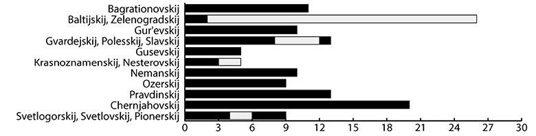
Fig 1. A diagram of registered hillforts in the Kaliningrad region, representing their territorial distribution. Compiled by O. Khomiakova.
1 pav. Registruotų Karaliaučiaus srities piliakalnių diagrama, atspindinti jų teritorinį pasiskirstymą. Sudarė O. Khomiakova
Our attention is called for the second-largest group of hillforts (about 30%) located in the Pregolya River valley (Fig. 1–2). This territory is poorly studied in the archaeological context (for details, see Khomiakova, 2016, p. 60–61). According to the data of the burial grounds, a separate group of sites – the Inster-Pregolian – is distinguished to belong to the 1st half of the first millennium AD (Engel, 1933, p. 278; 1935, p. 82; Okulicz, 1973, p. 401–402). During the the Roman period, the Inster-Pregolian group held an intermediate position between the Sambian-Natangian culture (or the Dollkeim-Kovrovo culture) and the East- and West-Mazurian groups of sites (the Bogaczewo and Sudovian cultures). Admittedly, the detachment of the Inster-Pregolian sites from the Sambian-Natangian culture has increased in the Migration period. Finally, the border between the two areas, passed by the Deima river, was formed in the Early Medieval period. Regarding the 13th century, the area of the Pregolya river basin, located eastward of the Deima river, is known as one of the old Prussian’s tribal territories – the Nadruvians (Grenz, 1975, p. 50–51). The core area of the Nadruvians developed over the tributary of the Pregolya river Gremjach’ja/Droje (prussic Drav) (e.g., Бартникас, 2003, p. 17–18). At the present time, the Central Nadruvians belongs to the Chernjahovskij District of the Kaliningrad region.
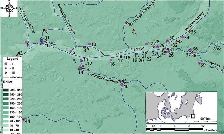
Fig 2. The archaeological situation in Central Nadruvians. I – hillfort, II – unfortified settlement, III – burial ground. Basis: a SRTM relief model. For a list of the sites, see Appendix 1. Compiled by S. Chaukin.
2 pav. Centrinės nadruvių teritorijos archeologijos paminklai. I – piliakalnis, II – neįtvirtinta gyvenvietė, III – laidojimo vieta. SRTM reljefo modelis. Paminklų sąrašą žr. 1 priede. Sudarė S. Chaukinas
Central Nadruvians, situated within the area of the prehistorical Instruch-Pregolian valley, is characterized by morainal landscapes, melted to the glacial-lacustrine plains, covered with impenetrable forests, low-level bogs and flood plains in pre-historical times. The frontier of the area is located near the present-day Chernjahovsk, by the bed of the Vishtyneckaja/Sudovian upland – the northern outskirts of the Baltic horseback. The area is developed by boulder trains near the benches of the Angrapa/Angerapp river, slipping into the Pregolian glaciolacustrine valley (Беренбейм, 1999, p. 195–198). According to the spatial analyses, the main concentration of the burial sites of the Inster-Pregolian group is located in this particular area. Sites are concentrated within the Pregolya river valley, by the lower reaches and influxes of its tributaries – the Golubaja/Auxinne and Gremjach’ja/Droje rivers. From the west, the area is limited by the Glubokaja/Nehne river, near the bet of the Instruch dead-ice ridge at the North bank of the Pregolya river, where the isolated sites of the Roman period are registered2 (for details, see Khomiakova, 2016, p. 69–71, Fig. 2–3).
Archaeological researches have shown that 20 hillforts are located within the territory of the Chernjahovskij district (Crome & Grunert, 1935, p. 4–7; Кулаков, 1985; 1987; 1988; 1989; Каталог, 2005, p. 92, 94–95; Калашников, 2009, p. 25–30). However, not even half of the fortified settlements were taken into account. Thus, the attention of the researchers was not drawn to the castles and fortresses, founded in the period of the Teutonic Order’s domination, known from Guise’s list of sites: Dovatorovka/Aulowöhnen, Kamenskoe/Saalau (Guise, SMB-PK MVF PM-IXh: 00268, 00271а–b). An exception is the Maevka/Georgenburg Castle, a fair bit investigated in the 1990s (Гусаков, 1992, p. 226–230).
We will make an attempt to break from the practice of reconstructing the archaeological situation, settlement pattern, and the social organization of the society in the territory of the formerly Central East Prussia solely according to burial data. This article presents the first observations regarding the settlement pattern of the 1st half of the first millennium in Central Nadruvians (i.e., the main concentration of Inster-Pregolian sites) using the analysis of settlements and by the search of criteria for the allocation of central places3 at one of the main contact zones of West Balt territories.
In light of the available information, the following questions arise. What are the differences between the hillforts in Central Nadruvians according to their morphological characteristics (sizes, structure) and datings? Are there any data or evidences of any inhabiting of the hillforts in the first half of the 1st millennium AD and any artefacts that may indicate any involvement in the system of contacts and exchange during the Roman and Migration periods? Finally, what could be the role and place of the hillforts in the social organization of the landscape and settlement pattern, particularly during the development of the Inster-Pregolian group of sites during the 1st half of the first millennium AD?
An analysis of central Nadruvian’s Hillforts
Eastward of the influx of the Glubokaja/Nehne and the Pregolya rivers, on the northern bank, the Kudrjavcevo 1/Kuglacken hillfort is situated (Hollack, 1908, p. 80; Каталог, 2005, p. 95). The hillfort is located on a cape, shaped by the confluence of two creeks at the rise, called “gora Obryv”/Schlossberg, about 0.5 km from the river bed (Fig. 3: 1). The total size of the hillfort is about 125 × 90 m, the area is about 1 ha. The height from the bottom amounts 16 m in southern part of the plateau and 12 m in the northern part. From the field side of the hillfort, traces of the rampart are about 1–2 m in height, and the ditch can be seen. The plateau has a rectangular form of about 87 × 48 m. The slops are guttered, escarped from the western side (Fig. 3: 2). In 1974, a test pit with an area of 1 m2, containing a cultural layer about 1.2 m deep, was excavated in at the plateau of the hillfort by Vladimir Kulakov (Кулаков, 1974, p. 6, Fig. 2, 29–33). Finds of handmade ceramics could probably be dated to the 1st half and middle of the first millennium AD (Fig. 4: 1–9). Two unenclosed settlements, Kudrjavcevo 2 and Kudrjavcevo 3, have been uncovered in the neighborhood of the hillfort. Handmade ceramics, similar to the pieces from the hillfort, were discovered on the surface of the Kudrjavcevo 2 settlement (Кулаков, 1974. p. 6–7, Fig. 1: 3, 29, 34, 36) (Fig. 4: 10). The Kudrjavcevo 3 settlement is located on the opposite side of the creek, on a plot of the bedrock coast of the Pregolya river (Кулаков, 1974, p. 7, Fig. 35, 37, 38). The presence of the foot settlement, situated to the east from the hillfort, was pointed by Karl Engel and mentioned in the archives of Herbert Jankuhn and Rudolf Grenz. In 1886, an accidental find, represented by the element of the horse harness, had been discovered here (Fig. 4: 11). The item is similar to Sambian-Natangian local elites’ harnesses, dated to the 2nd century (Lau, 2014, p. 39–48), and finds the closest analogies in the inventory of grave 23 of the Berezovka/Gross Ottenhagen burial ground, located in Pregolya’s valley (Ibsen, 2003, taf. 24–26). The significance of the microregion of Kudrjavcevo 1/Kuglacken hillfort in a transregional communication system as one of the central places is possibly indicated by finds of an imported weapon (a Roman sword – pugio), a fibula, a shield-boss and details of a horse harness made in the Jakovlevo/Ilischken burial ground (Guise I., SMB-PK MVF PM-A 041/1; Jaskanis, 1977, p. 278 – see earlier literature) in less than 2.5 km from the hillfort, upstream of the creek (Fig. 4: 12–15).
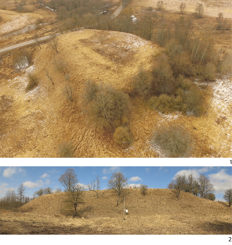
Fig. 3. The Kudrjavcevo 1/Kuglacken hillfort. 1 – an aerial photograph, view from NE. 2 – plateau of the hillfort, view from E. Photo by I. Skhodnov.
3 pav. Kudrjavcevo 1 / Kuglacken piliakalnis. 1 – aeronuotrauka, vaizdas iš ŠR. 2 – piliakalnis, vaizdas iš R. I. Skhodnovo nuotraukos
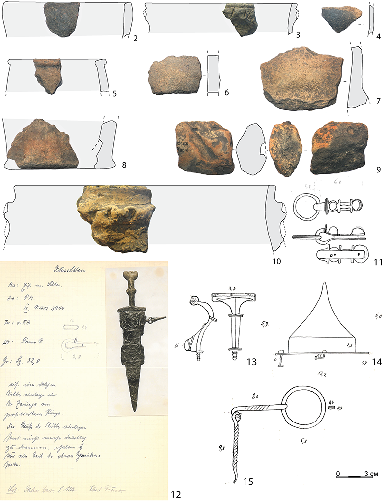
Fig. 4. Finds from the microregion of the Kudrjavcevo 1/Kuglacken hillfort. 1–8 – handmade ceramics from the hillfort, 9 – clay plump from the hillfort, 10 – ceramics from the Kudrjavcevo 2 settlement, 11 – a bronze element belonging to a horse harness from the Kudrjavcevo 3 settlement, 12–15 – accidental finds from the Jakovlevo/Ilischken burial ground. 1–10 – according to КГОМ № 9205, 11–15 – according to the H. Jankuhn archive. Compiled by O. Khomiakova.
4 pav. Kudrjavcevo 1 / Kuglacken piliakalnio mikroregiono radiniai. 1–8 – lipdytoji keramika iš piliakalnio; 9 – molinis pasvaras; 10 – keramika iš Kudrjavcevo 2 gyvenvietės; 11 – žalvarinės žirgo pakinktų detalės iš Kudrjavcevo 3 gyvenvietės; 12–15 – atsitiktiniai radiniai iš Jakovlevo / Ilischken kapinių. 1–10 – pagal КГОМ № 9205, 11–15 – pagal H. Jankuhno archyvą. Sudarė O. Khomiakova
The concentration of the archaeological sites in the Central Nadruvians rises upstream to the Pregolya near the confluence with its left tributary, the Golubaja/Auxinne river, within one of the largest “sandy islands” of the valley. The Golubaja/Auxinne river appears as an arm of the Angrapa/Angerapp river near the present day Majakovskoe (formerly Nemmersdorf, Kreis Gumbinnen) and could be one of the traffic roads from the Mazurian Lakeland in ancient times. The possible existence of a central place near the Golubaja/Auxinne confluence and its key position in communication system is pointed out by the policy of the Teutonic Order, which had founded two fortified settlements here (Mezhdurech’e/Norkitten and Kamenskoe/Saalau), on the opposite sides of Pregolya’s valley (see Fig. 2). The Mezhdurech’e/Norkitten castle was located near the Golubaja/Auxinne fall (Guise I., SMB-PK MVF PM-IXh 00269a; Hollack, 1908, p. 103; Кулаков 1985, p. 18–19, Fig. 75–76), though the hillfort (1st to early 2nd millennium AD (Bochagi/Schloßberg)) was located in a different place – two kilometres upstream of the Golubaja/Auxinne river (Guise I., SMB-PK MVF PM-IXh 00269b; Hollack, 1908, p. 145; Crome, 1940, p. 91).
The hillfort of Bochagi/Schloßberg (Vonwerk zu Norkitten) is placed within the loop of the river, on leadland (Fig. 5: 1). The total size of the hillfort is outstanding: about 450 × 250 m. The height from the river level is about 9–12 m. The plateau has a trapezoidal form and is oriented in the direction of the river loop. The hillfort consists of several elements: two plateaus, ramparts, and ditches. The first plateau has a small area about 63 × 100 m. From the field side, it is separated by a rampart up to 5 m, and traces of a ditch can be defined (Fig. 5: 2). The second rampart, up to 3 m, limits the plateau from the south (Fig. 5: 3). The area of the first plateau is cut by a road, enveloping the ramparts from the East and the West. Both ramparts could be escarped by the road. The second plateau of a trapezoidal form is about 335 × 210 m and has an area about 6.5 ha (see Fig. 5: 1). The plateau could have been occupied by a settlement. Entrances located on each side of the plateau are documented, but the dating of entrances is unclear.
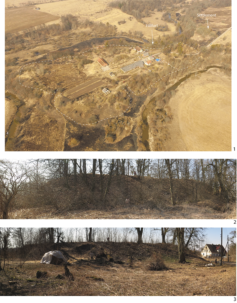
Fig. 5. The Bochagi/Schloßberg (Vonwerk zu Norkitten) hillfort. 1 – an aerial photograph of the hillfort with Bochagi 1 settlement, view from SE. 2 – the first rampart, view from N. 3 – the second rampart and plateau, view from N. Photo by I. Skhodnov.
5 pav. Bochagi / Schloßberg (Vonwerk zu Norkitten) piliakalnis. 1 – piliakalnio ir senovės gyvenvietės aeronuotrauka, vaizdas iš PR; 2 – pirmasis pylimas, vaizdas iš Š; 3 – antrasis pylimas ir aikštelė, vaizdas iš Š. N. I. Skhodnovo nuotrauka
Regretfully, no systematic archaeological investigations of the microregion were carried out. A few times, surveys were conducted at the hillfort (Кулаков, 1985, p. 16–17, Fig. 70–71; Говердовская, 2007, p. 10–11, Fig. 12). A test pit, excavated by Frida Gurevich in 1958 in the first plateau of the hillfort, did not give any bright material. Remnants of a stone (or brick-built?) setting with a few pieces of glazed ceramics inside were uncovered at a depth of 0.5 m (Гуревич, 1958, p. 3–4, Fig. 5–8). Certain information is furnished by Hollack, who mentioned the burial ground of the same period as located to the North from the hillfort (Hollack, 1908, p. 145). Could the hillfort have been a central place in the 1st millennium? In 2000, north from the ramparts of the hillfort, next to a ditch, during the course of works of a motorway’s reconstruction, the foot the settlement Bochagi 1 was discovered (Бакланова, 2002, p. 8–9) (Fig. 5: 1). Among the finds from the surface, lots of handmade ceramic pieces were found. The author dated them to the 6th–8th centuries (Бакланова, 2002, Fig. 15: 1–9). However, thin-profile vessels in the form of a jar with an inverted rim, ornamented with fingertip notches (see Бакланова, 2002, Fig. 14:1), could also be dated to the Migration period. During the survey, in 2018, lots of handmade ceramics pieces, which can be dated to the Roman period, were found at the second plateau of the hillfort. Items related to the Roman and Migration periods were recovered also in the inventory of the burial ground (Grunert, 1937, p. 59–61; Jaskanis, 1977, p. 302). The hillfort of Bochagi/Schloßberg was mentioned in written sources as one of the residences of the old Prussian chiefs, destroyed by the Teutonic Order in about 1275 (Crome & Grunert, 1935, p. 8–9); so, it could be regarded as a central place in the beginning of the 2nd millennium. The hillfort is also regarded as a possible place of a cult (Кулаков, 1985, p. 16–17, Fig. 70–71; Каталог, 2005, p. 93).
The Kamenskoe (Novo-Kamenskoe)/Siemohnen burial ground and unfortified settlement of the Roman period (Hollack, 1908, p. 150; Grunert, 1937, p. 26) were also discovered in the northern part of the microregion of the confluence of the Golubaja/Auxinne river. Their location is associated with the northwest top-end of the “sandy island” and the bank of the Torfjanaja/Auer river, which presents the right tributary of Pregolya. The hillfort of Poddubnoe/Auer-Schönwiese is located in the vicinity of the Torfjanaja/Auer confluence (Кулаков, 1985, p. 19–20, Fig. 79–82). The hillfort belongs to a particular type of fortified settlements (Fig. 6: 1, 3). It is located on a small sandy dune and has a round form. The size is about 110 × 100 m, and the area is about 1.2 ha. The height of the plateau from the river level is no more than 2 m. The hillfort is heavily damaged; however, originally, it was probably surrounded by a single ring-shaped rampart, which is partially preserved in the western part. The height of the rampart is about 1.5–2.0 m (Fig. 6: 2). No finds or traces of cultural layers were recovered at the plateau of the hillfort, so its chronology is unclear. Kulakov dated it to the 13th century (Кулаков, 1985, p. 20). The approach is probably rooted in the separation of a special type of the “island settlements,” performed on the basis of the fortified places of habitation of the Prussians, located along the course the Pregolya river (Bonk, 1895, p. 90–91). However, in this particular instance, fortified castles are referred to, such as Tapiau, Wehlau, Labiau, and Kneiphof (Bonk, 1895, p. 107–109). The Poddubnoe/Auer-Schönwiese hillfort is feasibly close to the different type of hillforts – the so-called Schwedenschanze. Hillfrots of the Schwedenschanze type are spread within the Baltic region and have an almost similar structure. They can be dated to the Late Bronze or the Early Iron age, but most of them belong to the Roman and Migration periods, representing both ritualistic and short-term protection functions (for details, see Lang, 2007, p. 75–81; Bliujienė, 2013, p. 194–198). In the area of the present-day Kaliningrad region, hillforts of the Schwedenschanze type are represented by few sites, among them are Rechki/Klein Pöppeln-Schwedenschanze, Nikitovka-Drozdovo/Lablacken-Kl., Droosden (Fig. 6: 4), and Rodniki/Jouglacken. Kulakov outlines denotes them using a special type “Б” (Кулаков, 1990, p. 9, 17–18, Fig. 2).

Fig. 6. The Poddubnoe/Auer-Schönwiese hillfort. 1 – an aerial photograph, view from S. 2 – a rampart, view from the plateau from W. 3 – eye sketching of the hillfort. 4 – a layout of the Klein Pöppeln/Schwedenschanze hillfort. 1–2 – photo by I. Skhodnov. 3 – by Каталог, 2005, p. 96. 4 – by Crome, 1940, p. 68.
6 pav. Poddubnoe / Auer-Schönwiesz piliakalnis. 1 – aeronuotrauka, vaizdas iš Š; 2 – pylimas, vaizdas iš aikštelės iš V; 3 – piliakalnio planas; 4 – Klein Pöppeln / Schwedenschanze piliakalnis. 1–2 – I. Skhodnovo nuotrauka. 3 – Katalogas, 2005, p. 96. 4 – Crome, 1940, p. 68
The analyses of the settlement pattern in the region of the confluence of Angrapa/Angerapp and Instruch/Inster, in the riverhead of Pregolya, are more complicated. The main concentration of the archaeological sites of the Inster-Pregolian group of the 1st half of the first millennium is located within the area of the confluence. The river valley is quite broad here and defined by a low flood plain. According to the data of burial grounds, sites are situated on the valley sides of the Pregolya river, on the south (left) bank of the Instruch/Inster river (Khomiakova, 2016, p. 70–71, Fig. 2: 2, 3: 2).
According to the information available, the largest fortified settlement within the microregion of the Pregolya’s riverhead is Krasnaja Gorka/Pillukztis (Käswurm, Nettienen4) (Guise I., SMB-PK MVF PM-IXh 00270a-b; Hollack, 1908, p. 103), located on the first shipping length of the Pregolya after the confluence (Fig. 7: 1). The hillfort is situated on the north high bedrock coast, where the dead-ice ridge develops into the main massive of the Instruch boulder train at the headland of the right bank of the creek, passing to Pregolya. The sizes of the hillfort are about 88 × 108 m, the area is about 1 ha. The height of the plateau from the creek level is about 10 m. The sizes of the plateau are about 35 × 50 m. The plateau of the hillfort is surrounded by a rampart up to 5–6 m in height from the field side (Fig. 7: 2). The rampart elevates above the plateau on the inside by 2 m. In the eastern part, there is an entrance to the plateau. Slopes are escarped. The hillfort of Krasnaja Gorka/Nettienen is mentioned in 1274 by Peter of Dusburg in The Chronicle of the Prussian Land as “Lethowis,” an Old Prussian settlement (Crome & Grunert, 1935, p. 7). In the 13th century, defensive elements of the hillfort were reconstructed by the Teutonic Order. Crome and Grunert described also a vorburg at the field side of the hillfort (Crome & Grunert, 1935, p. 7, 9). Kulakov, who conducted the survey in 1985, misplaced the hillfort as being on the opposite side of the creek. Nevertheless, pieces of handmade ceramics, which could be dated to the 1st millennium AD, were discovered at the slopes of the ravine (Кулаков, 1985, p. 18–19, Fig. 75–76). On the other side, the Krasnaja Gorka/Nettienen burial ground, which belongs to the Inster-Pregolian group of sites (Hollack, 1908, p. 103; Grunert, 1937, p. 22–23), is located not more then 0.8 km from the hillfort. Items that could possibly reflect any cross-cultural contacts with the Mazurian Lakeland during the 2nd–3rd centuries (Juga-Szymańska, 2014, p. 401–402), have been found at the burial ground (Fig. 8).
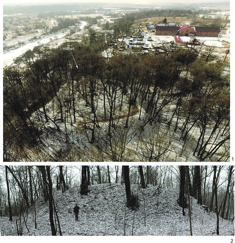
Fig. 7. The Krasnaja Gorka/Pillukztis (Käswurm, Nettienen) hillfort. 1 – an aerial photograph, view from E. 2 – a rampart, view from SE. Photo by I. Skhodnov.
7 pav. Krasnaja Gorka / Pillukztis (Käswurm, Nettienen) piliakalnis. 1 – aeronuotrauka, vaizdas iš R; 2 – pylimas, vaizdas iš PR. I. Skhodnovo nuotrauka
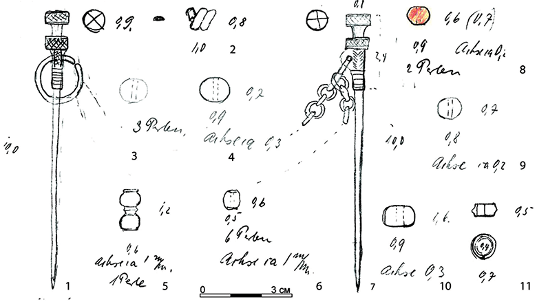
Fig. 8. An inventory of an urn cremation from the Krasnaja Gorka/Nettienen burial ground according to the H. Jankuhn archive. 1, 7 – bronze pins, 2–6, 8–11 – elements of a necklace. Compiled by O. Khomiakova.
8 pav. Degintinio kapo iš Krasnaja Gorkos / Nettieneno radiniai (piešiniai iš H. Jankuhno archyvo). 1, 7 – žalvariniai smeigtukai, 2–6, 8–11 – karoliai. Sudarė O. Khomiakova
The sites of the Inster-Pregolian group are also located within land on the border with the Central Nadruvians, on a limited plot of the Angrapa/Angerapp river-sides, where the outskirts of the Baltic horseback passes into the dead-ice ridge. The distance of Angrapa/Angerapp from its confluence with Pissa/Pissa was already considered Pregolya by locals (Bonk, 1895, p. 81–82), which corresponds with the landscape situation. A few kilometers from the confluence of the Angrapa/Angerapp and Pissa/Pissa rivers, where the watercourse changes its direction, the hillfort of Timofeevka/Tammowischken is situated (Hollack, 1908, p. 65; Кулаков, 1985, p. 20–21; 2017, p. 7–8). The hillfort appeared on a loop of the river (Fig. 9: 1–2); its structure probably has analogies with the Bochagi/Schloßberg hillfort, and it can be also considered as one of the central places of the beginning of the 2nd millennium. The hillfort was mentioned as the main fortress of the old Prussians in Nadruvians, seized by the Teutonic Order, in the Chronicle of Peter of Dusburg (Hollack, 1908, p. 161–162). The full dimensions of the hillfort match with the dimensions of the most significant hillforts in the Sambian peninsula (see Гуревич, 1960, p. 420–432).
The hillfort has an elongated triangular form and oriented in the direction of the river loop. The total dimensions of the hillfort are 195 × 60 m, the area is about 1 ha. The hillfort consists of several constructive elements – two ramparts, plateaus, and ditches. On the northeast side of the field, the hillfort is bounded by a 5–7 m high rampart, in front of which traces of a ditch can be found (Fig. 9: 3). The rampart separates the first plateau of trapezoidal shape, which is about 60 × 50 m and about 14 m in height, from the river level. From the southeast side, the plateau is bounded by a ditch 4–5 m deep, behind which a second plateau of about 70 × 40 m is situated. The height of this plateau from the river level is about 8–10 m. The slopes of both plateaus had been escarped. On the inner south side, the hillfort was probably separated by a ditch (or a dead arm of the river), which could have been filled up in the Early Modern Period, since a ramp had been made from the southern part of the hillfort.
A small-scale excavations were made at the hillfort by Evgenij A. Kalashnikov in 2002. Unfortunately they did not afford any bright material, which could provide an opportunity to receive any information about the nascent stages of the hillfort and the chronology of its defensive constructions. A pit of about 20 m2 was excavated at the northeast side of the second plateau not far from the rampart. Data from the excavation were divided into two “constructive” horizons: the “upper” horizon was dated to the 13th–18th centuries, and the “early” horizon – to the 10th–13th centuries. Pieces of handmade ceramics with a polished and patchy surface, which can be dated to the first millennium, were found in “early” horizon (Калашников, 2002, p. 26–30).
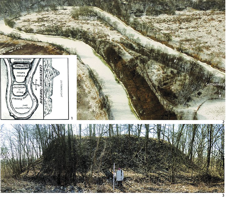
Fig. 9. The Timofeevka/Tammowischken hillfort. 1 – a sketching of the hillfort by M. Loebell according to the R. Grenz archive. 2 – an aerial photograph, view from SE. 3 – a rampart, view from field side from E. 2–3 – photo by I. Skhodnov.
9 pav. Timofejevo / Tammowischken piliakalnis. 1 – M. Loebello piliakalnio planas (iš R. Grenzo archyvo); 2 – aeronuotrauka, vaizdas iš PR; 3 – pylimas nuo piliakalnio išorės iš R pusės. 2–3 – I. Skhodnovo nuotrauka
Traces of anthropogenic treatment at the hillfort were confirmed by a reconnaissance survey. At about 25 m from the southern border of the second plateau of the hillfort, an unfortified settlement – Timofeevka 1 – was discovered (see Fig. 9: 2). The settlement is situated on the ledge of a second terrace above the Angrapa river. In 1985, when plowing at the surface of the settlement, pieces of handmade polished ceramics were recovered (Кулаков, 1985, p. 21, Fig. 89). Likely from the second plateau of the hillfort – a set of accidental finds, including a silver gold-plating buckle with a clip (Fig. 10: 1), few burned fragments of silver items and five roman coins originates (Rau, 2010, p. 311, Fig. 125: 7; Rudnicki, Skvorcov, 2015, p. 348–355). The buckle is close to the type of Snartemo-Sjörup and finds parallels in Southern Scandinavia and the Baltic Sea’s islands (for more details, see Rau, 2010, p. 309–313, Fig. 124–125), which can indicate the significance of the Timofeevka/Tammowischken microregion in the cross-cultural communication system during the period of the second half of the 5th to the beginning of the 6th century. According to the assumption of Mirosław Rudnicki, it probably confirms the mutual contacts with the area of the Olsztyn group during phase E (Rudnicki, Skvorcov, 2015, p. 252). Accidental finds of bracelets with cone-shaped terminals from the hillfort, known by their arrival data, can also be dated to the Migration period (Fig. 10: 2–3).
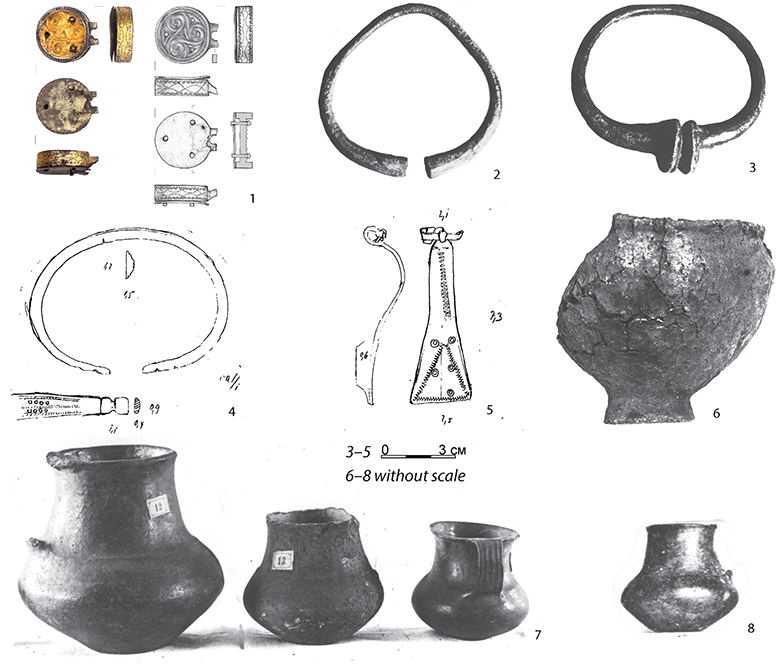
Fig. 10. Finds from the Timofeevka/Tammowischken hillfort and its vicinity. 1–3 – items from the plateaus of the hillfort: 1 – a silver gold-plating buckle, 2–3 – bronze bracelets. 4–8 – items from the burial ground: 4 – a bronze bracelet, 5 – a bronze fibula, 6–8 – handmade ceramic vessels. 1 – according to Rudnicki, Skvorcov, 2015, Fig. 3. 2–3, 6–8 – according to the R. Grenz archive. 4, 5 – according to the H. Jankuhn archive. Compiled by O. Khomiakova.
10 pav. Radiniai iš Timofejevo / Tammowischken piliakalnio ir jo apylinkių. 1–3 – radiniai iš piliakalnio aikštelės: 1 – sidabrinė auksuota sagtis, 2–3 – žalvarinė apyrankė. 4–8 – dirbiniai iš laidojimo vietų: 4 – žalvarinė apyrankė, 5 – žalvarinė segė, 6–8 – lipdytoji keramika. 1 – pagal Rudnicki, Skvorcov, 2015, fig. 3. 2–3, 6–8 – iš R. Grenzo archyvo. 4, 5 – iš H. Jankuhno archyvo. Sudarė O. Khomiakova
An advantageous position of the microregion, could have feasibly stipulated its development since the Stone Age. During the investigations in 2003, worked flints were discovered in the field sideways from the hillfort (Калашников, 2009, p. 17–19). Among the set of accidental finds performed in archives, stone axe-heads and a bronze socketed axe (celt) had occurred. In the vicinity of the hillfort, burial sites dated to the middle of the first millennium are known. Finds of handmade ceramic funeral vessels have been discovered (Hollack, 1908, p. 161–162; Кулаков, 2017, Fig. 3).
The microregion with the center located at the Timofeevka/Tammowischken hillfort obviously played its role in the settlement pattern during the Roman period. Apart from the finds of Roman coins from the plateau of the hillfort, a burial ground is located in the nearest neighborhood. A bronze “eye” fibula of type 61 according to Oscar Almgren’s typology (Almgren, 1923, p. 29–33, Taf. III: 61) (Fig. 10: 5), a bracelet with profiled terminals (Fig. 10: 4), and handmade funeral vessels (Fig. 10: 6–8), which find analogies both in the core area of the Sambian-Natangian culture and in the Mazurian Lakeland, which are dated to period between the end of the 1st and the beginning of the 2nd centuries (Хомякова, 2012, p. 46–50, 183–185, Map 17), were all found here. According to the archival information, the burial ground is located on the opposite side of the Angrapa river, on a morainal sand dune. Anu unfortified settlement of the Roman period should be located next to the burial ground (Grenz, archive). Presumably, the microregion of the Timofeevka/Tammowischken hillfort could be a boundary area of the Inster-Pregolian group of sites of the 1st half and middle of the first millennium.
Thus, the next hillfort, located up the Angrapa river – Zalivnoe/Walkenau (Erdmannsruhe (Hof) Peluczkstis) (Hollack, 1908, p. 78–79; Кулаков, 1985, p. 18, Fig. 73–74) – differs greatly from Timofeevka/Tammowischken by its structure. The hillfort is characterized by a rectangular plateau with dimensions about 15 × 10 m, 16 m in height from the water level. From the field side, the plateau is limited by a ditch about 5 m in depth, passing into a ravine (Fig. 11: 1). The first in a chain of fortified settlements, located in the course of the Instruch/Inster river, is the Botanicheskoe/Abschrutten hillfort (Hollack, 1908, p. 3, Кулаков, 1985, p. 15, Fig. 66–67) – and it is also vastly different. The hillfort occupies the headland of the bedrock and is located on a loop of a creek, flowing into Instruch. The plateau, rounded in form, has small dimensions of about 20 × 21 m. From the west, south and north, it is limited by steep slopes. From the east side, the hillfort is limited by a ditch, passing to the main massif of the bedrock (Fig. 11: 2). The small sizes of the Zalivnoe and Botanicheskoe hillforts can point to short-term protection or defensive functions, or they could be used as observation points. Their plateaus could have been a “shelter” with a wooden tower in its center, rounded by palisades and separated by a spitzwall (Bonk, 1894, p. 340–342). Analogies for this type of hillforts, according to our opinion, can be found among the hillforts of the Late Iron Age in Middle and Lower Neman/Nemunas river course – for example, the Kaukai and Grinaičiai hillforts (Kulikauskas, 1982, p. 97–98, Fig. 98; Zabiela, 2016, p. 186–187). Thus, the Zalivnoe and Botanicheskoe hillforts, in terms of their structure and chronology, lie outside the region under consideration.
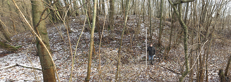
Fig 11. The Zalivnoe/Walkenau (Erdmannsruhe (Hof), Peluczkstis) hillfort, view from SW. Photo by I. Skhodnov.
11 pav. Zalivnoe / Walkenau (Erdmannsruhe (Hof), Peluczkstis) piliakalnis, vaizdas iš PV. I. Skhodnovo nuotrauka
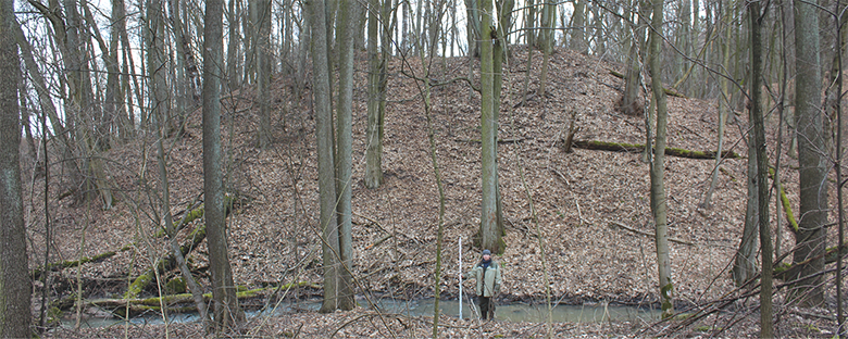
Fig 12. The Botanicheskoe/Abschrutten hillfort, view from S. Photo by O. Khomiakova.
12 pav. Botanicheskoe / Abschrutten piliakalnis, vaizdas iš P. O. Khomiakovos nuotrauka
Modelling and conslusions
Central Nadruvian hillforts, which could play a role of central places in the 1st millennium AD, are located on capes, which corresponds with the data concerning the hillforts in the Sambian peninsula (see Types “А,” “Д” according to Кулаков, 1990, p. 9, Fig. 1, 4). Cape-fortified settlements were situated both in a valley on the sides of the Pregolya river (the Kudrjavcevo 1 and Krasnaja Gorka hillforts) and on its left tributaries – the Angrapa and Golubaja/Auxinne rivers – presented by deep, strongly dissected valleys, matching up with flashy streams judging by their character (the Bochagi and Timofeevka hillforts).
An advantage of the native traits of the landscape, the moraine hills, capes, or loops of the rivers, was spent in constructing the fortified settlements in the first half of the 1st millennium in South Scandinavia and the East Baltic region. The construction of the Scandinavian fortified settlements of the Roman period was quite simple and consisted of a rampart, some ditches, and a wooden palisade. They could be used as protective shelters, assembly or cult places (Christensen, 2011, p. 93, 98). Close analogies find East Baltic hillforts in the Roman period (Lang, 2007, p. 44–47; Vengalis, 2016, p. 178–180).
The spatial analysis of Central Nadruvian’s hillforts shows their gravitation to Pregolya’s valley and the confluences of the main tributaries: the Podlesnaja/Raguppe сreek (Kudrjavcevo 1), the Golubaja/Auxinne river (Bochagi), and the Torfjanaja/Auer river (Poddubnoe). Hillforts situated at the Angrapa and Instruch rivers are associated with the riverbed. The location of these hillforts depends on the landscape peculiarities and is connected with river loops and the confluences of small creeks. All hillforts are located within the “key” regions in the transport communication system and are probably related to the control of the main transport artery of the region – the Pregolya river.
A visibility analysis is considered to be one of the principles of determining the dominating objects in a settlement pattern (for more details, see Коробов, 2014, p. 158–161; Verhagen, 2018, p. 18–19). Obviously, the hillforts of the Central Nadruvians were at an advantage, for they are located in the headlands. An analysis, based on a SRTM5 relief model created using the ArcGis 10.3 software, shows that it is possible to oversee and control the valley of the river from the hillforts (Fig. 13). Thus, the field of view of the Krasnaja Gorka hillfort, located on the right high bank, covers the first boatable distance of the Pregolya river. And its possible to observe the unfortified settlements of Novaja Derevnja 1–3, located on the opposite side of the river, as well as the network of the burial grounds of the Inster-Pregolian group: Krasnaja Gorka/Nettienen, Althof, Novaja Derevnja/Gaitzuhnen. The field of view from the Timofeevka hillfort encompasses a boatable strip of the Angrapa river from its confluence with Pissa. A large swath of the valley near the junction with the Glubokaja/Nehne river can be observed from the Kudrjavcevo 1 hillfort, as well as the last pass of the Golubaja/Auxinne river from the Bochagi hillfort.
The hierarchy of the objects as one of the elements of the settlement system of the region and the potential role of the hillforts are not that clear. One of the possible means to define the interdependence of the objects is an immediate neighborhood analysis.6 For the possible reconstruction of the buffer zones (zones of influence) of the hillforts, a 5-km diameter was accepted. On the one hand, a 5-km distance is equal to one hour on foot on uneven ground; on the other hand, it feats to the approximate distance between the hillforts in Central Nadruvians. The 5-km buffer zones are divided into 1-km branches. An analysis reflects that the location of the unfortified settlements and burial grounds of the Inster-Pregolian group could be connected with the zones of influence of the hillforts (Fig. 14).

Fig 13. A map of visibility from the Central Nadruvian’s hillforts of the 1st millennium. I – hillfort, II – unfortified settlement, III – burial ground. For a list of the sites, see Appendix 1. Compiled by S. Chaukin.
13 pav. Centrinės Nadruvos I tūkstantmečio piliakalnių regimumo žemėlapis. I – piliakalnis; II – neįtvirtinta gyvenvietė; III – laidojimo vieta. Paminklų sąrašas 1 priede. Sudarė S. Chaukinas
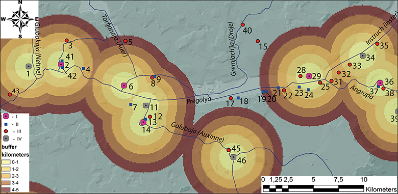
Fig. 14. A map of the distance between hillforts. I – hillforts of the 1st millennium, II – unfortified settlements, III – burial grounds, IV – hillforts of the Late Iron Age. For a list of the sites, see Appendix 1. Compiled by S. Chaukin.
14 pav. Piliakalnių išsidėstymo ir atstumų tarp jų žemėlapis. I – I tūkstantmečio piliakalniai; II – neįtvirtintos gyvenvietės; III – kapinynai; IV – vėlyvojo geležies amžiaus piliakalniai. Paminklų sąrašas 1 priede. Sudarė S. Chaukinas
A related position of unfortified settlements on the hillforts is marked. Most of them are situated close to the hillforts at a distance no more than 200–300 m, possibly forming single economic complexes (Kudrjavcevo 2–3, Krasnaja Gorka, Timofeevka 1–2, Bochagi 1). Other unfortified settlements are located at a 1–2 km distance from the hillforts (i.e., 20 minutes walking), and can be resolved by the overflowed lands, goods from the agricultural activities.
In contrast, burial grounds of the Roman and Migration periods are scattered across the analyzed surface. Most probably, a distinct relationship with the location of the hillfort was not important for burial grounds, while the crucial role was played here by the topographical situation. Burial grounds of the Inster-Pregolian group are located on a bedrock coast of the Pregolya river, or on the sole standing sand dunes by its tributaries. Sporadic objects standing away from the valley are also arranged with creeks, inflowing into Pregolya. Nevertheless, burial grounds with graves, containing Roman imports, prestigious goods and items reflecting the intercultural contacts (for example Althof, Krasnaja Gorka/Nettienen, Novaja Derevnja/Gaitzuhnen, Jakovlevo/Ilischken, Insterburg-Sprindt), are situated within the zones of the influence of the discussed hillforts.
The fact that the hillforts could play a role of central places during the Roman and Migration periods also can be indicated by separate finds of imported goods and items of a “higher social status” made on the plateaus and in the nearest neighborhood. Hillforts could be used not only for defensive purposes but also as places of residence for regional elites who had held the leading positions in the microregions and controlled communications as the leading persons of the craft centers and places of exchange. In such a way, the burial grounds that had provided the basis for allocating the main concentration of the Inster-Pregolian group near the present-day Chernyakhovsk are situated within the zones of influence of one or two hillforts. A settlement center could be formed here around an important traffic intersection. According to the analysis, the length of the site’s concentration of the Inster-Pregolian group near Chernyakhovsk is about 13 km.
The cultural landscape in Central Nadruvians and the formation of the concentrations of the Inster-Pregolian group during the Roman period depended, probably, on the confidences of the valleys of the main fivers as the transport arteries of the region and the landscape situation. All archaeological sites are located in the Instruch dead-ice ridge – a southern bank of the Pregolya river with a low swampy floodplain, and the area itself is covered with a forest that in ancient times was almost uninhabited. This particular situation had probably persisted until the Late Iron Age. In order to control the communication system, this being one of the aims, the fortresses of the Teutonic Order were founded at key lengths of Pregolya during the 13th–14th c.7 For that matter, the map of Gerard Mercator of 1628 (Fig. 15), which characterizes the ideas about the landscape situation during the Early Modern Period and the major settlement centers of the Nadruvians, is quite indicative. The fortresses and castles of the Teutonic Order were founded also on the spots of the Prussian hillforts close to type “Б” by V. Kulakov (Кулаков, 1990, p. 9, Fig. 3). According to the available information, Crusaders used the Krasnaya Gorka 1, Timofeevka, Mayevka hillforts (Hollack, 1908, p. 65, 79, 103; Кулаков, 1985, p. 18–19), and the Kamenskoe (Guise I., SMB-PK MVF PM-IXh 00271a).
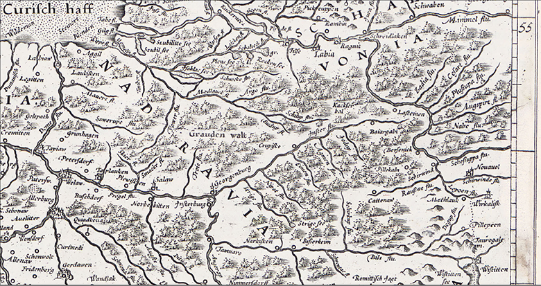
Fig. 15. A Map of Central Nadruvians by Gerard Mercator. Scale: 1:8000 000. Composed by O. Khomiakova according to Mercator, 1628.
15 pav. Gerardo Merkatoriaus centrinės Nadruvos žemėlapis. Mastelis 1:8 000 000. Sudarė O. Khomiakova, pagal Mercator, 1628
Finally, it should be noted that items known from the inventory of burial grounds of the 1st half of the first millennium AD, located within the intercultural areas of West Balt circle, indicate a high level of exchange and trade as well as the import of technologies and ideas (e.g., Новаковский, 2008; Banytė-Rowell, et al. 2016). The archaeological situation in Central Nadruvians, even at first sight, reflects the forming of central places and the character of the settlement pattern of the West Balts. Perhaps the units of the settlement pattern during the 1st half of the first millennium should be characterized as local territorial centers with attributes of central places. In this particular case, they can be correlated with the main concentrations of the Inster-Pregolian group of sites. The emergence of local centers in the “key” transport communications regions could be associated with a high level of exchange during the Roman period and could characterize the local elements of social structure based on a hierarchical proto-chiefdom with some of the local leaders who had controlled redistribution and exchange. All attributes of centerpoints of the central places in the Prussian hillforts were probably acquired during the Late Iron Age with the forming of chiefdom in its developed form.
Acknowledgements
Prof. Dr. Claus von Carnap-Bornheim (Centre for Baltic and Scandinavian Archaeology, Schleswig), Dr. Matthias Wemhoff, Dr. Heino Neumayer, Horst Junker, Horst Wieder (Museum for Prehistory and Early History, Berlin), Anatolij Novikov, Igor Muhachev, Aleksandr Sinichkin (NIC “Pribaltijskaya arheologiya,” IA RAS, Kaliningrad).
Translated by Olga Khomiakova
Appendix 1. List of archaeological sites in central nadruvians.
1 – Pushkino/Schloßerg von Taplacken, 2 – Kudrjavcevo 1/Kuglacken, 3 – Jakovlevo/Ilischken, 4 – Glushkovo/Plibischken, 5 –Krasnooktjabr’skoe/Groß Ponnau, 6 – Poddubnoe/Auer-Schönwiese, 7 – Mezhdurech’e 1, 8 – Kamenskoe/Sirenevka, 9 – Siemohnen, 10 – Kamenskoe/Saalau, 11 – Mezhdurech’e/Norkitten, 12 – Mezhdurech’e 3/Norkitten, 13 – Bochagi 1, 14 – Bochagi/Schloßberg, 15 – Gremjach’e/Birken, 16 – Zovrazhnoe/Schwägerau, 17 – Berezhkovskoe/Gross Bubainen, 18 – Berezhkovskoe 3, 19 – Berezhkovskoe 2, 20 – Berezhkovskoe 1, 21 – Novaja Derevnja 3, 22 – Novaja Derevnja/Gaitzuhnen, 23 – Novaja Derevnja 2, 24 – Novaja Derevnja 1, 25 – Chernjahovsk-Dachnaja/Althof, 26 – Chernjahovsk/Insterburg, 27 – Dovatorovka/Grossaulowönen, 28 – Krasnaja Gorka/Nettienen, 29 – Krasnaja Gorka/Pillukztis (Käswurm, Nettienen), 30 – Maevka/Georgenburg, 31 – Chernjahovsk 2/Insterburg, 32 – Chernjahovsk 1/Insterburg-Wasserwerk, 33 –Chernjahovsk-Timirjazeva/Insterburg-Sprindt, 34 – Botanicheskoe/Abschrutten, 35 – Botanicheskoe/Wengerin, 36 – Timofeevka/Tammowischken, 37 – Timofeevka 1, 38 –Timofeevka 3/Tammowischken, 39 – Zalivnoe/Walkenau (Erdmannsruhe (Hof), Peluczkstis), 40 – Gremjach’e/Gross Berschkallen, 41 – Kudrjavcevo 2, 42 – Kudrjavcevo 3, 43 – Livny/Stobingen, 44 – Suhodol’e/Holländerei, 45 – Rodnikovo/Friedensfelde, 46 – Belomorskoe/Gross Auxkallen (Schloßerg bei Friedensfelde), 47 – Sosnovka/Drusker Forst-Espenheim.
Manuscripts
Grenz R. Archive–Scientific archives of Rudolf Grenz, stored at the Archäologisches Landesmuseum Schloß Gottorf in Schleswig.
Guise I. Archive–Scientific archives of I. Guise, stored at the Staatliche Museen zu Berlin – Preußischer Kulturbesitz, Museum für Vor- und Frühgeschichte, Berlin.
Ibsen T. 2003. Das kaiserzeitliche und völkerwanderungszeitliche Gräberfeld von Berezovka/Groß Ottenhagen im Kaliningrader Gebiet. Eine archivalische Studie. Schriftliche Hausarbeit zur Erlangung des Grades eines Magister Artium (M.A.) der Philosophischen Fakultät der Christian-Albrechts-Universität Kiel. Kiel.
Jankuhn H. Archive–Scientific archives of Herbert Jankuhn, stored at the Archäologisches Landesmuseum Schloß Gottorf in Schleswig.
KГОМ. Калининградский государственный областной музей, фонды Калининградского областного историко-художественного музея, Калининград.
Бакланова Л.А. 2002. Отчет о разведке на участке будущего строительства автодороги в Черняховском районе Калининградской области в 2002 году. Архив ИА РАН/ Р–I, № 26558.
Гуревич Ф.Д. 1958. Отчет о работах в Калининградской области. Архив ИА РАН/ Р–I, № 1816.
Гусаков М.Г. 1992. Отчет об археологических работах в пос. Маевка Черняховского района Калининградской области. Архив ИА РАН/ Р–I, № 17154.
Коробов Д.С. 2014. Система расселения алан центрального Предкавказья в I тыс. н.э. (ландшафтная археология Кисловодской котловины). Дисс. … докт. ист. наук. Т. 1. М. Архив ИА РАН, Р–2.
Кулаков В.И. 1974. Отчет по обследованию археологических памятников Калининградской области. Архив ИА РАН/ Р–I, № 5273.
Кулаков В.И. 1985. Отчет о работе Балтийской экспедиции в 1985 году. Архив ИА РАН/ Р–I, № 10913.
Кулаков В.И. 1987. Отчет о работе Балтийской археологической экспедиции ИА АН СССР в Калининградской области. Архив ИА РАН/ Р–I, № 11895.
Кулаков В.И. 1988. Отчет о работе Балтийской экспедиции. Архив ИА РАН/ Р–I, № 12554.
Кулаков В.И. 1989. Отчет о работе Балтийской экспедиции ИА АН СССР. Архив ИА РАН/ Р–I, № 13482.
Хомякова 2012а. Женский убор самбийско-натангийской культуры периода Римского влияния I–IV вв. н.э. (Анализ компонентов и хронология): Дисс. … канд. ист. наук. М.// Архив ИА РАН, Р–2, № 2809–2810.
Literature
Almgren A. 1923. Studien über die nordeuropäische Fibelformen der ersten nachchristlichen Jahrhunderte mit Berücksichtigung der provinzialrömischen und südrussischen Formen. Leipzig: Habelt.
Banytė-Rowell R., Bitner- Wróblewska A., Reich C. 2016. West Lithuania as a golden bridge between the sea and the Baltic Hinterland in Notheast Poland during the Roman and Migration Periods. Archaeologia Baltica, 23, p. 140–151.
Bliujienė A. 2013. Romėniškasis ir tautų kraustymosi laikotarpiai. Lietuvos archeologija, III. Klaipėda: Klaipėdos universiteto leidykla.
Bonk H. 1895. Die Städte und Burgen in Altpreussen (Ordensgründungen) in ihrer Beziehung zur Bodengestaltung zur Bodengestaltung. II. III. Altpreußische Monatsschrift, 32. Königsberg: Beyer, p. 73–185.
Bonk H. 1894. Die Städte und Burgen in Altpreussen (Ordensgründungen) in ihrer Beziehung zur Bodengestaltung. I. Altpreußische Monatsschrift, 31. Königsberg: Beyer, p. 320–342.
Carnap-Bornheim von C., Ibsen T., Prassolow J. A. 2016. Forschungskontinuität und Kontinuitätsforschung – Siedlungsarchäologische Grundlagenforschung zur Eisenzeit im Baltikum. C. von Carnap-Bornheim (ed.) Zentrum für Baltische und Skandinavische Archäologie. Eine Forschungseinrichtung der Stiftung Schleswig-Holsteinische Landesmuseen Schloss Gottorf. Jahresbericht 2016, p. 52–55.
Christensen K. 2011. Fertile Central Zealand – Iron Age settlement at Ringsted. L. Boye (ed.) The Iron Age on Zealand: Status and Perspectives. Copenhagen: Royal Society of Northern Antiquaries, p. 268–270.
Crome H. 1940. Führer zu den frühgeschichtlichen Burgwällen im Samlande. Sitzungsberichte der Altertumsgesellschaft Prussia, 34, p. 5–83.
Crome H., Grunert W. 1935. Verzeichnis der vor- und frühgechitlichen Wehranlagen im westlichen Nadrauen. Altertumsgesellschaft Insterburg, 20. Insterburg: Altertumsgesellschaft Insterburg, p. 1–11.
Engel K. 1933. Die kaiserzeitichen Kulturgruppen zwischen Weichsel und Finnischen Meerbusen und ihr Verhältniss zueinander. Sitzungsberichte der Altertumsgesellschaft Prussia, 30/I, p. 261–296.
Engel K. 1935. Vorgeschichte der alterpreußusche Stämme. Untersuchungen über Sirdlungstätigkeit und Kulturgruppen im vorgeschichtlichen Ostpreußen, I. Königsberg i. Pr.: Gräfe und Unzer Verlag.
Grenz R. 1975. Der Kreis Wehlau in vor- und frühgeschichtlicher Zeit. W. Lippke (ed.) Heimatbuch des Kreises Wehlau. Alle-Pregel-Deime-Gebiet, I. Leer: Verlag Gerhard Rautenberg, p. 25–55.
Grunert W. 1937. Nadrauer Grabungen. Altertumsgesellschaft Insterburg, 21. Insterburg: Altertumsgesellschaft Insterburg, p. 7–61.
Hollack E. 1908. Erläuterungen zur vorgeschichtlichen Übersichtskarte von Ostpreußen. Glogau; Berlin: Flemming.
Jaskanis J. 1977. Cmentarzyska Kultury zachodniobaltyjskej z okresu rzymskiego. Materiały Starożytne i Wczesnośredniowieczne, IV. Warszawa: Zakład Narodowy im. Ossolińskich, p. 239–350.
Juga-Szymańska A. 2014. Kontakty Pojezierza Mazurskiego ze wschodnią strefą Bałtyku w okresie wpływów rzymskich na przykładzie szpil. Fundacja Monumenta Archaeologica Barbarica. Seminarium Bałtyjskie 3. Warszawa:Państwowe Muzeum Archeologiczne.
Khomiakova O. 2016. The Landscape and spatial analysis of Roman Period archaeological sites at the Eastern border of Dollkeim-Kovrovo/Sambian-Natangian culture. Archaeologia Baltica, 23, p. 58–80. https://doi.org/10.15181/ab.v23i0.1297
Kulikauskas P. 1982. Užnemunės piliakalniai I–XIII amžiuje. Vilnius: Mokslas.
Lang V. 2007. The Bronze and Early Iron Ages in Estonia. Estonian Archaeology, 3. Tartu: University of Tartu Press. https://doi.org/10.26530/OAPEN_423939
Lau N. 2014. Die Pferdegeschirre. Germanische Zaumzeuge und Sattelgeschirre als Zeugnisse kriegerischer Reiterei im mittel- und nordeuropäischen Barbaricum. C. von Carnap-Bornheim (ed.) Das Thorsberger Moor, 1. Schleswig: Verein zur Förderung des Archäologischen Landesmuseums e.V., Schloss Gottorf.
Mercator G. 1628. Prvssia. Sive Cosmographia. Available at: <https://img.raremaps.com/xlarge/37251.jpg> [accessed on 18 April 2018].
Nakoinz O. 2010. Concepts of Central Place Research in Archaeology. J. Müller (ed.) Landscapes and Human Development: The Contribution of European Archaeology. Proceedings of the International Workshop “Socio-Environmental Dynamics over the Last 12,000 Years: The Creation of Landscapes (1st–4th April 2009), Universitätsforschungen zur prähistorischen Archäologie, 191. Bonn: Rudolf Habelt, p. 251–265.
Okulicz E. 1973. Pradzieje ziem pruskich od późnego paleolitu do VI w. n.e. Wrocław–Warszawa–Kraków–Gdańsk: Zakład Narodowy im. Ossolińskich.
Rau A. 2010. Nydam Mose: Die personengebundenen Gegenstände, Grabungen, 1989–1999. Text. (ed.) F. Rieck Nydam Mose, 1. Jutland Archaeological Society publications, 72. Aarhus: Carlsbergfondet.
Renfrew С., Bahn P. 2012. Archaeology: Theories, Methods, and Practice. 6 edition. London: Thames and Hudson.
Rudnicki M., Skvorcov K. 2015. Znalezisko sprzączki typu Snartemo-Sjorup z Nadrowii. Wiadomości Archeologiczne, LXVI, p. 348–355.
Vengalis R. 2016. Old and Middle Iron Age Settlements and Hillforts. G. Zabiela, Z. Baubonis, E. Marcinkevičiūtė (eds.) A Hundred Years of Archaeological Discoveries in Lithuania. Vilnius: Society of the Lithuanian Archaeology, p. 160–181.
Verhagen P. 2018. Spatial Analysis in Archaeology: Moving into New Territories. C. Siart et al. (eds.) Digital Geoarchaeology, Natural Science in Archaeology, 15, p. 11–25.
Webley L. 2008. Iron Age Households: Structure and Practice in Western Denmark, 500BC–AD200. Aarhus: Aarhus University Press.
Zabiela G. 2016. Late Iron Age Hillforts. G. Zabiela, Z. Baubonis, E. Marcinkevičiūtė (eds.) A Hundred Years of Archaeological Discoveries in Lithuania. Vilnius: Society of the Lithuanian Archaeology, p. 182–191.
Бартникас А. И. 2003. Названия прусских земель и племен: этимологический аспект. И. В. Ерофеев (ред.), Надровия: историко-краеведческий журнал, 2, Черняховск–Калининград: РГУ им. Канта, р. 17–18.
Беренбейм Д. Я. 1999. Калининградская область: очерки природы. Калининград: Янтарный сказ.
Гуревич Ф. Д. 1960. Из истории Юго-Восточной Прибалтики в I тысячелетии н. э. (по материалам Калининградской области). М. А. Тиханова (pед.). Материалы и исследования по археологии СССР. Древности северо-западных областей РСФСР в первом тысячелетии н.э., 76, р. 328–451.
Калашников Е. А. 2002. Камсвикус. Археология. Предварительные результаты разведывательных археологических работ на городище Тимофеевка–Камсвикус (бывший Таммовишкен) Черняховского района Калининградской области. И. В. Ерофеев (ред.) Надровия: историко-краеведческий журнал, 1. Черняховск: комитет по образованию, культуре, спорту и туризму администрации муниципального образования «Черняховский район», р. 25–30.
Калашников Е. А. 2009. Археологические работы на поселении Тимофеевка – Камсвикус в 2003 году. И. В. Ерофеев (ред.) Надровия. Историко-краеведческий журнал, 6. Черняховск–Калининград: РГУ им. Канта, р. 17–22.
Каталог 2005: Памятники археологии, памятники искусства. Город Калининград, Калиинградская область. А. М. Тарунова, Е. В. Судальцева (ред.) Каталог объектов культурного наследия Калининградской области, 6/IV. Калининград–Москва: Научно-производственный центр по охране, учету и реставрации памятников истории и культуры Калининградской области.
Кулаков В. И. 1990. Древности пруссов VI–XIII вв. B. B. Седов, Б. А. Рыбаков (ред.) Свод археологических источников, Г1-9. Наука.
Кулаков В. И. 2012. Исследования памятников археологии первой половины I тысячелетия н. э. в Калининградской области в 1946–2010 гг. Komunikaty Mazursko-Warmińskie, 275. Olsztyn: Zakład Małej Poligrafii OBN, р. 91–110.
Кулаков В. И. 2017. Kamswikus/Тимофеевка: раскопки и находки. В. А. Шахов (ред.). Проблемы межрегиональных связей. Научный льманах, 12. Калининград–Москва–Клайпеда: Научно-исследовательский центр имени П. А. Румянцева «Мысль», р. 6–11.
Новаковский В. 2008. Мазурско-надровская альтернатива – Янтарный путь в эпоху Августа и Тиберия. Ю. В. Костяшов, А. Н. Федорова (ред.) Калининградские архивы: материалы и исследования. Калининград: Калининградский государственный университет, р. 40–52.
Хомякова О. А. 2014. Культура Доллькайм-Коврово (самбийско-натангинская): подходы к дефинициям общности. Российская археология, 1, p. 163–172.
Хомякова О. А. 2016. Западнобалтская культура I тыс. н. э.: подходы к определению археологической общности и смена концепций. Д. С. Коробов (ред.) Развитие взглядов на интерпретацию археологического источника. Материалы Всероссийской научной конференции. Москва: ИА РАН, 2016, p. 74–76
Centrinių nadruvių piliakalniai: senosios Rytų Prūsijos gyvenvietės modelio ir socialinės organizacijos I tūkstantmečio po Kr. pirmojoje pusėje atvejo tyrimas
Olga Khomiakova, Ivan Skhodnov, Sergey Chaukin
Santrauka
Galios ir statuso centrai, ryšių ir mainų keliai, jų kontrolė svarbūs tyrinėjant Šiaurės Europos ir Baltijos jūros pietinės pakrantės archeologines kultūras romėniškajame ir ankstyvajame tautų kraustymosi laikotarpiuose. Straipsnyje pristatomi pirmieji centrinių nadruvių I tūkstm. po Kr. pirmos pusės gyvenviečių tyrimų rezultatai. Tyrimai atlikti svarbiausioje šių genčių archeologinių vietovių susitelkimo vietoje, Įsruties-Priegliaus baseine, Sembos ir Natangos archeologinės kultūros teritorijoje (1–2 pav.). Analizuotas tokių gyvenviečių pasiskirstymas, nustatyti jų centrai ir kriterijai šioje vienoje iš svarbiausių vakarų baltų kontaktų teritorijoje. Straipsnyje nagrinėjami centrinių nadruvių svarbiausi I tūkstm. piliakalniai: Kudrjavcevo1 / Kuglacken, Bochagi / Schloßberg (Vonwerk zu Norkitten), Poddubnoe / Auer-Schönwiese, Krasnaja Gorka / Pillukztis (Käswurm, Nettienen), Timofejeva / Tammowischken (3, 5–7, 9 pav.). Visi jie yra Priegliaus upės ir jos kairiųjų intakų Angrapos (Unguros) ir Golubaja (Auksinė) slėniuose. Piliakalnių konstrukcijos turi panašumų į I tūkstm. pirmos pusės Pietų Skandinavijos ir Rytų Baltijos regiono įtvirtintas gyvenvietes. Visi piliakalniai yra „raktiniai“ regiono kelių komunikacijų sistemai ir, matyt, susiję su pagrindinės regiono transporto arterijos – Priegliaus upės – kontrole (13 pav.). Archeologijos paminklų analizė rodo, kad Įsruties-Priegliaus grupės neįtvirtintos gyvenvietės ir laidojimo paminklai gali būti siejami su piliakalnių įtakos zonomis (14 pav.). Pažymėtina, kad neįtvirtintos gyvenvietės atsiranda prie piliakalnių. Įsruties-Priegliaus grupės laidojimo paminklai romėniškajame ir tautų kraustymosi laikotarpiais priklausė nuo kraštovaizdžio ypatybių. Nors laidojimo paminklų kapuose yra romėniško importo, prabangos prekių, atspindinčių tarpkultūrinius kontaktus (pavyzdžiui, Althof, Krasnaja Gorka/Nettienen, Novaja Derevnja/Gaitzuhnen, Jakovlevo/Ilischken, Insterburg-Sprindt), jie visi yra aptariamų piliakalnių įtakos zonose (4, 11–15, 8, 10:4–8 pav.). Kad piliakalniai romėniškuoju ir tautų kraustymosi laikotarpiu galbūt atliko centrų vaidmenį, taip pat rodo pavienės importuotos prekės bei „aukštesnio socialinio statuso“ daiktai, kurie pagaminti artimiausiose apylinkėse (4:1–10, 10:1–3 pav.). Aptariami piliakalniai galėjo būti naudojami ne tik gynybiniais tikslais, bet ir kaip regiono diduomenės rezidencijos, mikroregionų, komunikacinių kelių kontrolės, amatų ir prekybos centrai. Laidojimo paminklai, kurių daugiausia aptinkama Įsruties-Priegliaus upių baseine, netoli dabartinio Černiachovsko miesto, yra vieno ar dviejų piliakalnių įtakos zonoje. I tūkstm. centrinių nadruvių piliakalniai galėjo būti vietinių teritorinių junginių centrai, svarbiausios jų vietos, įrengtos svarbiausių kelių sankirtose. Vietinių teritorinių centrų susiformavimas romėniškuoju laikotarpiu gali būti siejamas su prekybiniais mainais aukšto lygio dirbiniais ir charakterizuojamas kaip vietinės socialinės struktūros, kurioms būdinga protovadystės hierarchinė sistema. Visi prūsiškų piliakalnių kaip centrinių vietų požymiai tikriausiai galutinai susiformavo vėlyvajame geležies amžiuje, kuriantis vadystės (angl. chiefdom) sistemai.
1 In this article, the term “archaeological cultures of the West Balts” denotes the community of the Roman period archaeological cultures located in the Southeast Baltic Region (for details, see Bliujienė, 2013, p. 78–80, Fig. 24). For details on the term “Sambian-Natangian culture” – see Хомякова, 2014, p. 163–172; 2016, p. 74–76.
2 The western concentration of the Inster-Pregolian group of sites, located on the outbursts of the Instruch dead-ice ridge, at the so-called sandy islands on the south bank of the Pregolya river, near the present-day Gvardejsk, is not discussed in this article.
3 For details about the term “central place”, used in the article and the criterions – see Nakoinz, 2010, p. 252; Korobov, 2014, p. 81–91 – see earlier literature.
4 Fortified settlements of the 1st millennium could also probably be located in the same places as the latter castles of the Teutonic Order (Chernjahovsk/Insterburg, Maevka/Georgenburg). The data, however, are not preserved.
5 LiDAR data for the territory of the Kaliningrad region are unavailable.
6 The distance from each point to its nearest neighbor is calculated and compared with the average distance between neighbors. Thus, the average value among all possible pairs is determined. The average value gives the extent of points in a field.
7 Fortified settlements of the Teutonic Order in Central Nadruvians, as a rule, situated on isolated hills up to 15–16 m high from a foot, are located on the confluences with Pregolya’s tributaries. They are bounded by ramparts and ditches from the field side. The slopes are escarped. Their location was determinated by the dominate position on the point of the river’s communication and was stipulated by access to water, which was necessary for the construction of wells and watermills (Bonk, 1894; p. 227–228, 234–235). Therefore, Old Prussian’s fortified settlements of the Late Iron Age, located on isolated hills, were not used by the Crusaders (see Bonk, 1895, p. 73–74).