Archaeologia Lituana ISSN 1392-6748 eISSN 2538-8738
2022, vol. 23, pp. 176–194 DOI: https://doi.org/10.15388/ArchLit.2022.23.11
Pytheas the Massaliot and the Baltic. Myth or Reality?
Søren Skriver Tillisch, MPhil
Primary school for gifted children (Atheneskolen), Denmark
soren4@hotmail.com
Abstract. Pytheas the Massaliot travelled the entire European coastline from Gades (Cadiz) to the mythological northern mouth of the Tanais (Don), circumnavigated Britain, reached ultima Thule, probably the Faroes, and the amber island of Abalus, probably Thy, and Norway, possibly the land of the Periscians.
This article revisits the idea of Pytheas reaching the Baltic, very possibly the area of the northern mouth of Tanais (Vistula? Nemunas?), and the idea of Kaali on Saaremaa as “the place where the sun went to bed”’. The examination of the question is introduced with a historiographical excursus and chapters on the scientific background of the journey, the measurements of Pytheas, his hometown Massalia and his journey as far as the Western Baltic. The argument will be exposed through analysis and comparison of the archaeological and written evidence.
In conclusion it is argued that Kaali on Saaremaa was visited by Pytheas the Massaliot and may indeed be considered “the place where the sun went to bed” but not “ultima Thule”.
Keywords: Pytheas the Massaliot, Ancient Greece, The Baltic, Sarema.
Pitėjas Masilietis ir Baltija. Mitas ar tikrovė?
Anotacija. Pitėjas Masilietis (gyveno IV a. pr. m. e.), senovės graikų geografas, apkeliavo Europos pakrantę nuo Kadiso (Cadiz) iki Tanais (prie Dono žiočių), apiplaukė Britaniją, pasiekė Ultima Tulę, tikriausiai Farerus, gintaro salą Abalus ir tikriausiai Norvegiją. Straipsnyje dar kartą apžvelgiama Pitėjo, pasiekusio Baltiją, šiaurinės Tanais žiočių (Vyslos? Nemuno?) kelionės ir Saremos Kaali, kaip „vietos, kur saulė nuėjo miegoti“, aplankymo klausimas. Problema nagrinėjama, pasitelkiant istoriografinį ekskursą, Pitėjo ir jo gimtojo miesto Masalijos matavimus, kelionę iki vakarų Baltijos, analizuojant ir lyginant archeologinius ir rašytinius įrodymus. Apibendrinant teigiama, kad Pitėjas Masilietis apsilankė Kaali Saremos saloje ir iš tiesų ši vieta, bet ne „ultima Thule“, gali būti laikoma „vieta, kur saulė nuėjo miegoti“.
Reikšminiai žodžiai: Pitėjas Masilietis, senovės Graikija, Baltija, Sarema.
___________
Received: 11/07/2022. Accepted: 08/11/2022
Copyright © 2022 Søren Skriver Tillisch. Published by Vilnius University Press. This is an Open Access article distributed under the terms of the Creative Commons Attribution License, which permits unrestricted use, distribution, and reproduction in any medium, provided the original author and source are credited.
Introduction
It is today beyond reasonable doubt that Pytheas the Massaliot, who claimed to have travelled the entire European coastline from Gades (Cadiz) to the mythological northern mouth of the Tanais (Don), circumnavigated Britain, reached ultima Thule, probably the Faroes, and the amber island of Abalus, probably Thy, and Norway, possibly the land of the Periscians, those who live around the shadow, i.e. the northern polar circle.
The evidence for reaching the Baltic is much less conclusive.
One example, the identification of Kaali on Saaremaa as “the place where the sun went to bed” and shown to Pytheas by the Barbarians, and the island itself as “ultima Thule” (Meri, 1976), has been doubted due to serious concerns about the archaeological and historical probability (Mägi, 2004) and the fact that the two interrelated fragments mentioning it appear to allude to Odyssey I,22–25. The use of Homeric references should, however, be expected in almost any Greek source from the 4th century BC, and so does not preclude that the possible Homeric allusion does not have some basis in reality.
The following article will explore this possibility through careful analysis of the archaeological and written evidence applying a model for using written and archaeological sources together first developed more than a decade ago (Tillisch S. S., 2009). The basic tenet of this model is that archaeological and written sources may be used together if there is corroborative evidence.
A case in point would be “Caesar’s lilies” mentioned during the battle for Alesia in Bel.Gal. VII,73. “Carsea’s lilies” were sharpened wooden poles placed pointing upwards in holes or ditches covered with brush by the Roman legionaries. Corresponding examples in Denmark, notably around the fortified site Borremose, the early village of Grøntoft and the somewhat later Lystbækgård site has been plausibly explained through Caesar (Jensen J., 2003, p. 94–98). This is an example where an apparetently unrelated historical source may provide a possible answer to archaeological finds elsewhere.
The model should be used sparingly, not least when working with a fragmentary work like Pytheas the Massaliot’s. Any interpretation will be bereft with caveats and debatable conclusions, but this should not deter an attempt to revisit the evidence for Pytheas the Massaliot’s presence in the Baltic. Thus I will in the following reexamine the archaeological and scientific evidence for this and compare the evidence to Geminos Phainomena 9,6 and Pliny Naturalis Historia 4,94–106 directly mentioning Pytheas and also the possible relation to Argonautica 4,590–656 and Ptolemaios Klaudios
The examination will be introduced with a historiographical excursus and short notes on the scientific background of the journey, the role of Massalia, the measurements of Pytheas and his journey as far as the Western Baltic.
Historiography
Many German works (Schmitt A., 1876; Kähler F., 1903) and Christopher Hawkes (Hawkes C. F. C., 1978) have argued that Pytheas reached the area around the Oder or the Vistula and East Prussia with its large amber reserves. Recently Bianchetti has suggested that parts of the description of the Baltic coast in Pliny Naturalis Historia 4.94–104 also derives ultimately from Pytheas the Massaliot and is integrated in the later Roman sources in Pliny’s work (Biancheti S., 2020, p.15–16).
It was, however, only rather late and in an unscientific way that the journey was extended to the north, to Saaremaa and Kaali lake, claimed to be “the place where the sun went to bed” and Thule (Meri L., 1976). While not a trained archaeologist or historian he still compared the archaeological findings around the crater to nearby sites like Asva and Ridala, in trying to back up his claim. This claim played a small part in Estonian nation building in the 1970s and 1980s as Estonian ‘westernness’ was postulated, a development tacitly encouraged by Western powers (Sommer L., 2019), and this is possibly the reason that a theory supported by very little evidence and written by a nonarchaeologist has been accepted as at least a reasonable hypothesis, though it has also received heavy criticism by archaeologists (Mägi M., 2004) as well as historians, notably Herbert Ligi. It should also be noted that the idea of Thule as Estonia plays a part not only in Lennart Meri’s westernized postcolonial thoughts but also in his ideological counterweight Jaan Kaplinski’s Vercingetorix ütles (‘Vercingetorix said’, 1965) in which Ultima Thule features alongside Styx, the river around Hades, in Kaplinski’s argument that much of ‘Estonianness’ really is a construct of the 19th Century and heavily influenced by German ideological ideas, whereas Kaplinski hails the Eastern elements of Estonian culture (Sommer L., 2019, p. 3–5). Interestingly, this quote, translated into English, from Vercingetorix ütles makes quite clear the root of Meri’s ideas:
So be it imperator: let there be in your republic
one language, one faith and one people.
Let the road be secure and smooth/
for your soldiers, merchants and crooks/
as far as Ultima Thule
and up to the River Styx
Since Meri suggested that “Ultima Thule” was Saaremaa and that the Kaali meteorite crater was “the place where the sun went to bed” all scientific articles concerning the crater have in some way been forced to relate to the idea. Most of these studies have been written by nonspecialists in Classics and tend to give the idea the benefit of the doubt, though actual archaeologists remain much more sceptical (Mägi M., 2004, p. 83). A relatively recent work has attempted to prove Meri being right (Talvik R., 2015) but is written by a nonspecialist, a medical scientist, rather than a historian or an archaeologist, and has not resolved the matter.
The scientifc background of Pytheas’ journey
Pytheas the Massaliot’s journey took place in the late 4th century BC. At that point in time the Greeks operated within an understanding of the oikoumene and the kosmos developed by the Ionian natural philosophers in the 6th–5th century BC, and this understanding is described in Herodotos of Halicarnassus’ Historia (around 430 BC).
This world, fundamentally a flat disc surrounded by the Ocean was, from the age of Anaximander in the later 6th century BC suspended in a cylindrical kosmos, from the later half of the 5th century BC it became a circular Earth in a circular kosmos. The people of Greece, Egypt and Mesopotamia lived in the oikoumene while the Scythians were thought to live to the north, the Persians to the east, the Aithiopians to the south and the Celts to the west (fig.1) in the dangerous periphery. The Greek poleis to the west, of which Massalia was one, were small societies on the limits of the oikoumene, and therefore potentially strange and dangerous places to those living in Hellas proper (Fabre P., 1981, p. 1–7).
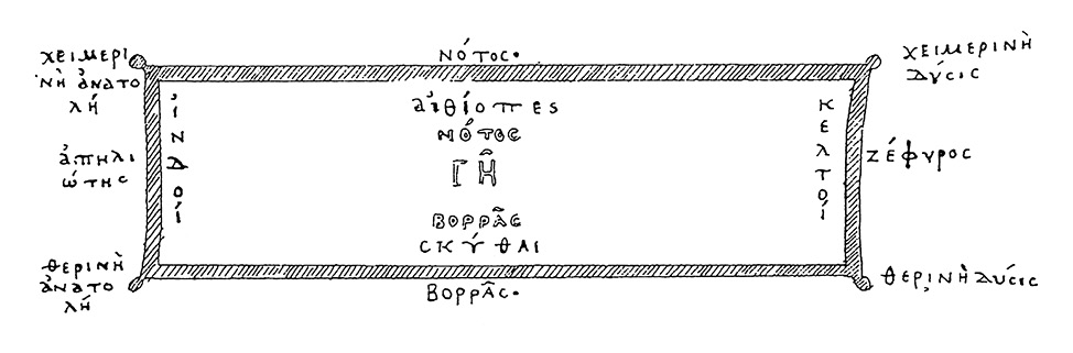
Fig. 1. World map of Ephorus (4th Century BC). Based on Kosmas Indikopleustes (6th Century AD). From Wolska-Konus W. 1968, 397.
1 pav. Eforo pasaulio žemėlapis (IV a. pr. Kr.). Remiantis Kosmas Indikopleustes (VI a. po Kr.). Iš Wolska-Konus W. 1968, 397
The two great rivers of the Nile in Africa and the Istros (Danube) in Europe where both thought to have a twin mouth corresponding to the ones in the Mediterranean and the Black Sea – in the Atlantic Ocean (probably the Senegal) and the Mediterranean (the Rhône) respectively. This curious idea stemmed from the idea of a symmetrical kosmos. The idea of the second mouth was also assumed for the Tanais, as it emptied into the Maeotis (Azov Sea). Thus the claim by Pytheas that he reached the northern mouth of the Tanais lead us to search for river mouths along Europe’s northern seaboard, of which more below.
The basic design of this kosmos was not fundamentally altered during Antiquity. It had to be adjusted to the circular Earth in the 5th century BC, and the Persian and Alexandrian Wars opened the world to the east up, as the Massaliot and Carthaginian explorers did in the west, but mostly these new discoveries were suppressed in literature and often presented as adjustments to the already existing knowledge (Bianchetii, 2008, 2020; Clarke K., 1999, p. 308–312; Fabre P., 1981, p. 20–22).
It would seem that the concept of the Earth as round came to be in the late 5th century BC. “The Clouds” clearly allude to a circular Earth suspended in “aether” by Aristophanes of about 423 BC. Meton, who is lampooned in “The Birds” (998 ff.) is a likely early proponent for the idea, since he also developed the Metonic cycle based on the 19 year cycle of the Moon, later a central component of the Antikythera mechanism (Jones A., 2017, pp. 47–52).
It is important to understand that only with further observations concerning the movement of the Sun, the Moon and the planets it was possible to scientifically determine the sphericity of the Earth in the first half of the 4th century BC through Eudoxus of Cnidus, who also realised the importance of the tropics and the northern polar circle (Mittenhuber F., 2003, p. 44–45).
Instruments and measurements in Pytheas
The following will focus on instruments, stadia and solar heights and their assumed and apparent real precision. Up until the age of Pytheas we have no actual measurements of geographical distances, and his measurements of parallels are thus probably the oldest available (Heidel W. A., 1937, p. 8–11, 56–59). We find a number of measurements in the corpus of Pytheas the Massaliot – stadia, solar heights, sailing days and sailing days-and-nights. Therefore it is necessary to ascertain, if possible, which measurements Pytheas used.
Often it has been stated that the measurements were executed with a simple gnomon and a measurement pole with scaled and movable plates and the basic measurements of a foot, a cubit and a stade (Lewis M., 2001, p. 40–46). Recent research, notably on the aforementioned mock description of one of Meton’s instruments, and in the description of Eratosthenes’ instruments, notably the ‘skiotherikos gnomon’ have, however, cast doubts on the simplicity and scarcity of types of the instruments involved (Leigemann D. et al., 2005, p. 238–39). Further, the imprecision amounting to 3–400 stades or 34 arc seconds, assumed by many, including Eratosthenes (Heidel W. A., 1937, p. 125), have been questioned while using a device reconstructed based on ancient descriptions of Meton’s instruments, called a ‘diabetes’ (fig. 2, Leigemann D. et al., 2005, pp. 240). This instrument is basically a ‘shadow catcher’ placed on top of a turntable with 360 degrees and the 24 Greek ‘winds’ marked on the turntable, and the measured precision is down to 50 stades (8 km) or 5 arc seconds, i.e. close to that of a sextant. As we shall see the precision indicated by the preserved measurements of Pytheas the Massaliot would seem to be greater than 34 arc seconds and closer to 5 arc seconds, thus indicating the use of such a ‘shadow catcher’.
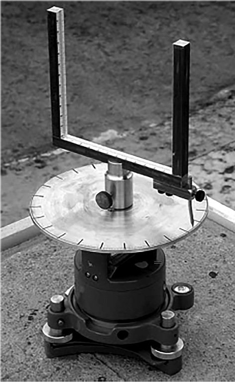
Fig. 2. Reconstructed “shadow catcher” based on descriptions in ancient sources. Possibly called a 'diabetes'. Leigemann et al. 2005, Abb. 4, p. 243.
2 pav. Remiantis senovės šaltinių aprašymais rekonstruotas „šešėlių gaudytojas“. Galbūt vadinamas „diabetu“. Leigemann et al. 2005, Abb. 4, p. 243
As for the specific measurements there were some constants. Thus a cubit was divided into 24 daktyls (‘fingers’), and 12 daktyls corresponded to one foot. Further 600 feet corresponded to one stadion (Historia 2.149), and one degree in the sky corresponded to one foot or half a cubit. However, the exact length of the daktyl, foot, cubit and stadion varied widely across the ancient world (Gulbekian E., 1987, p. 357; Lehmann-Haupt K., 1929, col. 1931–1933).
The archaeologically preserved athletic stadiums from Archaic, Classical and Hellenistic Greece fall into three general groups where the stade must be considered to be circa 165, 180 or 191 metres. Thus the stadiums in Korinth, Delphi and Halieis were 165, 167 and 166.5 metres (median 166.17 metres). The stadiums in Delphi, Nemea, Athens, Epidauros and Isthmia were 177.15, 177.6, 184.3, 181.3 and 181.2 metres, respectively (median 180.32 metres). This is also the length a modern athletics stadium is modelled after, at 177.82 metres. Finally, the stadiums in Olympia, Milet and Priene were 191.28, 192.3 and 191.3 m, respectively (median 191.63 metres). The medians correspond to feet of circa 27.5, 29.6 or 32 cm, in Antiquity known as the Oscan-Italic, Attic (later Roman) and Doric foot (Romano D., 1993, p. 17–22; Gulbekian E., 1987, p. 357, 362–363).
Relating to the subject of this article archaeological excavations point to the preferred foot in Massalia was about 30 centimetres (i.e. the Attic foot) in 6th–4th century BC, and 27.5 cm (i.e. the Oscan-Italic foot) in 4th–3rd century BC (Tréziny H., 1989, p. 11–14, 18–20, 46).
Let us now proceed to what the sources tell us about Pytheas’ measurements.
Our main source here is Strabo:
Geographika 2.1.12, 18:
“2.1.12. Since Byzantion (Istanbul) and Massalia are almost under the same parallel of latitude, as Hipparchus tells us they are, on the authority of Pytheas, and since Byzantion and the Borysthenes have also the same meridian, as Hipparchus equally assures us, if we take his assertion that there is a distance of 3700 stadia between Byzantion and the Borysthenes, there will of course be a like difference between the latitude of Massalia and the Borysthenes. This would make the latitude of the Borysthenes identical with that of Keltike next the Ocean; for on proceeding 3700 stadia, we reach the ocean.
2.1.18.…..Hipparchus narrates that at the Borysthenes and the north of Keltike, during the whole of the summer nights there is one continued twilight from sun-set to sun-rise, but at the winter solstice the sun never rises more than nine cubits above the horizon. He adds that this phenomenon is yet more remarkable in regions 6300 stadia north of Massalia, (these regions he supposes to be peopled by Kelts, but I believe are inhabited by Britons, and 2500 stadia north of Keltike) where the sun at the winter solstice rises only six cubits above the horizon. That at 9100 stadia north of Massalia it only rises four cubits, and not so much as three in the countries beyond, and which I consider much farther north than Ierne (Ireland). However, Hipparchus, on the authority of Pytheas, places them south of Britain, and says that the longest day there consists only of 19 hours; while in countries where the sun rises but four cubits above the horizon, and which are situated 9100 stadia north of Marseilles, the day has 18 hours. Consequently the most southerly parts of Britain must be north of these regions.”
(English translation slightly adapted from The Geography of Strabo. Literally translated, with notes, in three volumes. London. George Bell & Sons. 1903. At: http://www.perseus.tufts.edu/hopper/text?doc=Perseus%3Atext%3A1999.01.0239%3Abook%3D2%3Achapter%3D1%3Asection%3D18)
We are here told that Massalia and Byzantion is almost on the same latitude, off by about two degrees (43’17 N vs. 41 N) and we are provided a notation of the distances between parallels north of Massalia of 3,700, 6,300 and 9,100 stadia where the sun rises nine, six and four cubits at winter solstice, i.e. 12, 8 and 6 degrees if 0.5 cubit is one degree. It should thus be possible to pinpoint the latitudes and thereby the stadion used, since the inclination of the Earth relative to the ecliptic today is almost the same as in the 4th century BC (23’43’28 relative to 23’43’40 degrees).
The crucial information given is the one where we are told that at 9,100 stadia north of Massalia the midsummer day is 18 hours long. This corresponds to 58’13 north and to a winter solstice rise of 8 degrees or 4 cubits. The distance in kilometres between 43’17 and 58’13 north (14’56 degrees) is 1659.39 km, i.e. 14 degrees of 111.12 km, 56 arc minutes of 1.852 km. This would correspond to a stadion of about 182.35 metres and a foot of 30.4 centimetres. Very close to the foot known archaeologically in Massalia in the 6th–4th century BC and the Attic foot. Incidentally, 58’13 is tangential to Cape Wrath, Scotland’s northernmost point and very likely the Orkas of Pytheas the Massaliot. This parallel is also “right below the head of the Dragon (constellation)” as the expression goes in Krates of Mallos and Aratus, possibly reflecting a Pythean tradition, and coinciding with the Arctic circle as seen from Rhodes (Bilic T., 2012, p. 304).
Accepting 182.35 m as the stadion used here, 3,700 stadia north of Massalia corresponds to 48 degrees North, a parallel following the north coast of Britanny which is Pytheas’ most probable route, and besides there are several sites with evidence of cross-channel contact on the north coast of Britanny from this period. Most importantly the apparent emporium at Le Yaudet and the necropolis at Urville-Naqueville (Cunliffe B. & Galliou P., 2004; Fischer C. et al., 2018).
Still using 182.35 m as the stade, 6,500 stades north of Massalia corresponds to 54 degrees north. In the British Isles this parallel runs along the northern Irish coast, through Morecambe Bay with its heavy tide, possibly the site of Pytheas’ “sea lung” on the west coast and the prominent Flamborough Head on the east coast and across the North Sea to the mouth of the Elbe and along the northern Baltic coast.
Finally the three cubits or six degrees at winter solstice mentioned by Strabo corresponds to the situation on the Shetlands (61 N) where the midsummer day is 19 equinoctal hours, among the parallels mentioned by Geminos in Phainomena (see below).
To conclude the measurements of Pytheas, accepting a stadion of 182.35 m shows a remarkable precision consistent with the use of an instrument like the reconstructed “shadow catcher”. Given this it is very probable that Pytheas used a stadion of 182.35 metres, but notes concerning Thule complicates matters a bit.
Strabo tells us in Geographika 2.5.8:
“It is true that Pytheas the Massaliot affirms that the farthest country north of the Brittanides is Thule; for which place he says the summer tropic and the arctic circle is all one. But he records no other particulars concerning it; whether Thule is an island, or whether it continues habitable up to the point where the summer tropic becomes one with the arctic circle.”
And according to Eratosthenes in Strabo, Geographika 1.4.2:
“…Again; from thence [the Hellespont] to the Borysthenes, 5000; and thence to the parallel of Thule, which Pytheas says is six days’ sail north from Britain, and near the Frozen Sea, other 11,500 [stadia].”
And finally according to Ptolemaios Klaudios in Description of the Geography 8.2:
“Thus it is that at Thule the longest day is 20 equinoctal hours.”
This latter claim is corroborated by Stephanos of Byzantion in the Suda.
These facts are somewhat contradictory. The central point is Ptolemaios. If Thule is where the longest day at midsummer is 20 hours this would mean a parallel of about 62 degrees North, a parallel passing through the Faroes and south central Norway near Ålesund. This corresponds quite well to six days sailing north of Britain, since this is likely what it would take a Greek ship travelling about 2 knots to reach the Faroes from Cape Wrath. Experimental sailing with a replica of the Kyrenia wreck, Kyrenia II, put the average speed at 2–3 knots, less in weather where the ship had to cross to the wind (Katzev, 1987, p. 250). This is also comparable to experimental sailing with replicas of Viking Age ships (Englert A., 2012, pp. 275–278). Some researchers believe that Ptolemy’s latitude of Thule is a matter of speculation to accommodate his geographical-mathematical theories, and not based on actual observations (Shcheglov D., 2007, p. 5–7). However, the correspondence between experimental archaeology, the six days and nights and the 20 equinoctal hours of the longest day strongly suggest that Ptolemaios’ Thule is real enough, and probably can be identified with the Faroes.
This conclusion is at first sight at odds with the measurement in stades. Thus we are told that Thule’s position is six days north of Britain where the summer tropic is the same as the Arctic Circle (i.e. the actual Arctic circle). If the 11,500 stades north of Borysthenes mentioned are 182.35 m this would mean that Thule would be in 65’07 degrees North, a parallel crossing northern Iceland and entering Norway in Nord-Trøndelag not too far from the actual Arctic circle. Thus this would indicate that Thule is Iceland or Norway, but also that Eratosthenes, Strabo’s source in this case, and Pytheas used the same length of the stadion.
However, 11,500 stades north of Massalia using 182.35 metres corresponds to 62 N, i.e. the place where the Arctic circle would be as seen from Massalia and also the parallel of 20 equinoctal hours where Thule is supposed to be according to Ptolemaios Klaudios and the Suda. Thus a mistake in mixing different measurements, done by either Eratosthenes or some later scribe, is all it would have taken to create the confusion, i.e. mistaking the 11,500 stades north of Massalia for 11,500 stades north of Borysthenes. Given the great precision shown above in all the other measurements by Pytheas the Massaliot it seems unlikely that he should have missed so massively on the parallel of Thule, and a later error by Eratosthenes, Strabo or someone else mistaking Borysthenes for Massalia most likely created the confusion.
A final example concerning the stadion Pytheas used. In Strabo Britain’s circumference is stated to be 40,000 stades. In Diodorus Siculus it is stated to be 42,500 while Pliny in his Naturalis Historia has it at 4,875 Roman miles. Using 182.35 m as the stade the former two translates as 7,294 km and 7,749.5 km, while 4,875 Roman miles correspond to 7,220 km. Based on this it would seem that Pliny recalculated a measurement akin to the one mentioned by Strabo. This circumference has been claimed to be way too high by Strabo and many modern researchers. However, through dynamic coastal theory this point is moot. A coast line is measured in steps, and it is important how many ‘steps’ any given coastline is divided in. Unfortunately it is rare that the number of ‘steps’ and conditions for any given coastline measurement is relayed. And different ‘steps’ entails different lengths (Mandelbrot B., 1967; Lynch P., 2013; Rae A., 2016). Surprisingly, few researchers have actually tested Strabo’s claim. Even researchers who ought to know better postulates that Caesar’s 2,000 Roman miles are more precise than Pytheas (e.g., Horst Roseman C., 1994, p. 126; Steensby H. P., 1918, p.16). True enough Caesar’s numbers are possible within dynamic coastal theory, even if it is distinctly at the lower end of the scale, but so are Pytheas’. Thus Pytheas’ circumference of Britain is a qualified guess and reinforces the likelihood of his use of the stade of 182.35 metres as Pliny’s length in Roman miles corresponds well to at least one measurement given by the Greek sources, i.e. Strabo.
Thus Pytheas the Massaliot knew the Earth was round, and his measurements likely proved this as verifiable fact, just as his observations in the north of Europe formed the core of later Greek, Roman and even Medieval and early modern beliefs about the farthest north of Europe (Small M., 2007, p. 321).
A short note on Massalia
Massalia was founded through a journey from Phokis in Asia Minor around 600 BC according to archaeological as well as historical sources (Tréziny H., 2011, p. 42; Clavel-Leveque M., 1977, p. 7). In the following centuries it became the preeminent Greek site in the northwestern part of the Mediterranean well known for its flourishing trade, and it was a node in a sea route from Greece along the Italian peninsula past another Phokaian colony, Velia, and on to Massalia, Emporion and Gades on the Atlantic coast of Iberia. As other Greek ‘apoikiai’ (i.e. “houses away from home”) Massalia existed in a complex interaction with the native population of the region (Dietler M., 2009, p. 8–10; Hermary A. et al., 1999, p. 31–33).
Massalia’s development in the first half of the 6th century BC seems to reflect that of open and dynamic emporia in the Mediterranean at the time such as Pyrgi, Emporion and Huelva (Tartessos?), possibly best understood as gateway communities (Py M. & Trézinny H., 2013, p. 238–239). As it swelled due to an exodus, yet another journey from Phokaia recently conquered by the Persians (cf. Morel J. P., 2006, p. 1728–1745) in the 540s BC, it obtained dominance of the exchange routes of southern Gaul and founded trading stations at Theline/Arelate (Arles) in the mouth of the Rhône and at Agathe (Agde) at the mouth of the Hérault connecting it with the Gironde, and thus the Atlantic facade (Hermary A. & Tréziny H., 2015, pp. 237–238).
During the 5th and early 4th centuries BC there seems to have been two realignments of the exchange routes around Massalia, one around 475–450 BC, the other around 400 BC related to the breakdown of the Hallstatt D complex in Central Europe, and both realignments were followed by Massaliot expansions, in the latter of which Pytheas journey fits well. During all three expansive periods Massaliot pottery, coins and other Greek objects spread deep into the interior of Gaul and spurred complex multilayered local developments, though Etruscan and Phoenician influences are also palpable especially in the 6th century BC (e.g., Fernandez-Götz M., 2018, p. 121–126, 148; Bizot B. et al., 2007, p. 30–31; Clavel-Léveque M., 1977, p. 20–26; Van den Boom H. / Pape J., 2000, p. 48–61; Pape J., 2000, p. 71–74, 112–119).
The richness of Massalia and its place on the edge of the world known to the Greeks (and later the Romans) led to an idea of Massalia as a ‘soft’, effeminate and decadent society with special rites and cults (i.e. syncretism). This is famously expressed in Petronius’ Satyricon, and the sentiment may have had negative influence on the scientific information relayed by Massaliots such as Pytheas (Arcelin P., 1992, p. 318–319; Jensson G., 2018, pp. 11–13). This is probably the reason for the apparent ignorance of Massaliot geographical exploits in the 6th as well as the 4th century BC by the likes of Herodotus, Polybius and Strabo (Bianchetti S., 2008, pp. 23–24).
Born out of several journeys to what was then the end of the world it should come as no surprise that someone from Massalia travelled further north than ever before in the search of resources and knowledge and the end of the world, or at least the oikoumene, just as Kolaios of Samos and Aristeas of Proconessus before him.
The journey as far as the western Baltic
Pytheas probably went from Massalia along the exchange route past Emporion through the Straits of Gibraltar to Gades (Cadiz). It has often been claimed that he would not have been able to pass the Straits due to a Carthaginian blockade, but this blockade is neither evident in the abundant material on Graeco-Phoenician interaction in Iberia and Gaul, nor in the historical sources (Py M. & Tréziny H., 2013, p. 267; Bianchetti S., 2008, p. 17–20).
Then he seems to have turned south following the ocean currents, possibly to avoid the kelp forests around Cape Spartel, later turning north towards Cabo Sao Vicente, one of many so designated holy promontories of the ancient world. Then he apparently went due north to Finisterre in Galicia, probably named Oestrymnis by the locals, meaning “westernmost”. Then he seems to have taken the direct route across the Bay of Biscay to reach Brittany, apparently also known as Oestrymnis, and settled by a people variously spelled by Strabo (Geographika 1.4.5, 4.4.1) and Stephanus of Byzantium (Ethnoi 712.21) as Ostidaeans, Ostidamnioi, Ostidaei, Ostiones or Oisismioi (also probably meaning something like ‘the westernmost’). Pytheas most likely knew them as Ostidamnioi. He also notes another (?) name for Oestrymnis, Kabaion, probably meaning a rock dipping into the sea, which could well be Pointe du Raz on the western tip of Britanny.
It should be noted that the route from Agde (Agathe) up the valley of the Hérault and Garonne to the Gironde, past the mouth of the Loire and the trading station Korbilon, is also a possibility (Cunliffe B., 2001; Horst Roseman C., 1994). There is also no doubt that this route was much frequented during the 3rd and 2nd centuries BC.
However, Pytheas’ journey seems in part to retrace the periplous behind Ora Maritimma by Rufus Festus Avienus, probably dating somewhere around 500 BC, and the aim of the journey seems to have been to establish new trading contacts in the far north as well as exploration (Bianchetti S., 2008, p. 27–29). Judging from the finds of Greek and Carthiginan coins in Wales and southern England as well as the expansion of trading centres along the English coast in the 3rd and 2nd centuries BC Pytheas’ journey was successful in this respect. The presence of Carthaginian coinage and finds also speaks toward competition in trade, not war between Phoenicians and Greeks. Further there is evidence that after Pytheas the land route was considered the more efficient one, and that it was heavily used leading to an expansion of the settlement at Agde.
Finally, one of the main arguments for the land based first leg of the journey is that Polybios through Strabo stated that the people of the trading station at Korbilon in the mouth of the Loire “had never heard of him (Pytheas)” (Strabo, Geographika 4.2.1). Thus invalidating the journey to Strabo, Polybios and many later researchers. However the statement only tells us that Pytheas was not at Korbilon, and since Polybios is a century and a half younger we cannot know if Korbilon existed in Pytheas’ time.
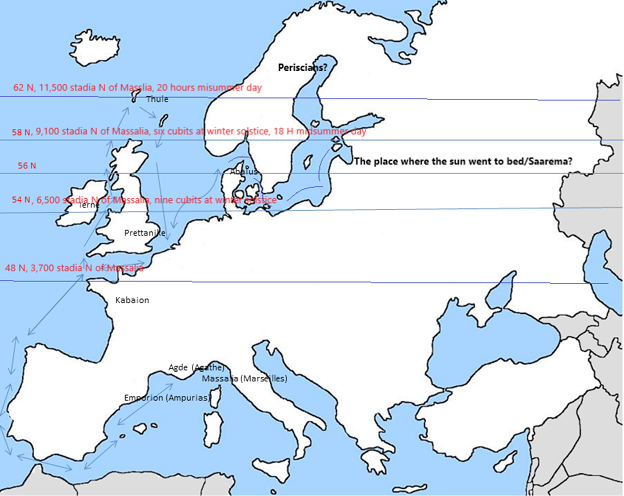
Fig. 3. Sketch map of Europe with parallels and distances indicated in stadia of 182.35 metres.
3 pav. Eskizinis Europos žemėlapis su paralelėmis ir atstumais – 182,35 metro
Indeed no trading settlement has been traced in the estuary of the Loire in the correct time slot, and the 3,000 stades mentioned by Pytheas for crossing from Oestrymnis to Kabaion corresponds well to the distance between the Finisterres in Galicia and Britanny (Strabo, Geographika 1.4.5), and for that matter also reflects the ancient Greek estimate of a ship covering 1,000 stades in one day. Further Polybius had acute interest in downplaying Massaliot exploits and enlarging his own in the face of his Roman patron, Scipio the Younger (Bianchetti S., 2008, p. 38).
Reaching Oestrymnis/Kabaion he passed Uëxisame, known to the Romans as Axanthos and today as Ile d’Ouessant or Ushant. As noted, he took a parallel close to this area. Then he probably crossed to Pretannike (Britain) from Britanny and made landfall at Land’s End (Belerion), and from there he seems to have sailed north through the Irish Sea to the Hebrides (Hebudes) and on to northern Scotland and the Orkneys (Orkas). Then further north to the Shetlands (Haemodes) and, as we have seen, Thule, i.e. the Faroes. Thule probably means ‘hill’ or ‘promontory’ and since the ancient writers clearly include Thule in the Bretannides, the lesser British Isles, it is very difficult to conclude that Thule is Iceland or Norway. Indeed the Latin epitet “ultima Thule”, i.e. “the farthest hill/promontory” would fit well with the Faroes.
From the Faroes Pytheas may have continued west or north, but given the distances already covered and the probably looming winter, it is more likely that he turned south and wintered at Kantion (Kent). In Kantion there is plenty of evidence for southern contacts in etymology as well as archaeology. Thus the area west of the now silted Wantsum Channel was known as the Isle of Thanet, and it has been suggested that the etymology for this name is the Phoenician goddess Tanit (Vennemann T., 2006, p. 357–359), much as Gades had a “temple of Juno” according to Pliny (i.e. Tanit). Archaeologically the strongest evidence come from Cliff’s End Farm which was a liminal place with burials of people with Scandinavian, British, Mediterranean and North African descent stretching over several centuries in the Bronze and Iron Age (McKinley J. et al., 2017, p. 166–168).
From Kantion the following spring it is likely that Pytheas followed the European coastline to the north east. Thus he had the land of the Belcae to the right, probably the later Belgae, and he passed the aestuarium Metuonidis, probably the marshy coast from the Schelde estuary to the Watten Sea. From here he seems to have continued north along the Jutland coast and reached Abalus, the holy island, also known as Basilia, i.e. ‘royal’. The name is cognate with Celtic *aball, Gaulish *avallo, meaning ‘apple’ and reminds us of the name of the holy island Avalon in Arthurian legend (Hawkes C. F. C., 1978, p. 9). One is also reminded of the Idun’s golden apples of Nordic mythology and the apples of the Hesperides in Greek mythology. This island is almost certainly Thy, and the Limfjord, at this time entered from the north through the Sløj Channel, and may well be “the northern Tanais”. It also seems that Pytheas explored “the land along the Ocean”, probably Norway and the “Periscians”, literally those who live around the shadow, i.e. the Polar Circle (fig. 4).
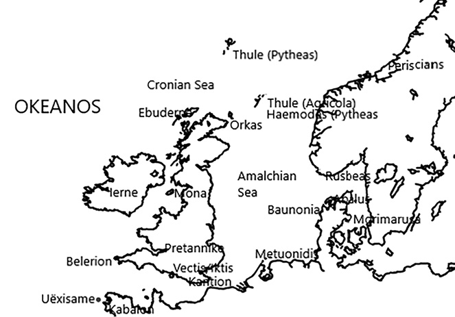
Fig. 4. Map of NW Europe with most notable names originating from Pytheas the Massaliot.
4 pav. Šiaurės Vakarų Europos žemėlapis. Dauguma jame esančių pavadinimų kildinami iš Pitėjo Masiliečio
But did he also reach the Baltic and possibly even Saaremaa? Let us have a look at the archaeological, scientific and written evidence.
The scientifc and archaeological evidence – the Kaali Crater
The Kaali crater and its eight satellite craters is on Saaremaa at 58’22 N, 22’40 E. Successive radio carbon dates on various parts of the debris, wood and peat inside the crater at different levels before 1995 has produced dates ranging in 1800–600 BC (Losiak A. et al., 2016, p. 688–690; Veski S. et al., 2004, p. 198–199). Two outliers are represented by testing microspherules in nearby bogs and suggested a date of 6500–6270 BC while testing the Ir-rich peatlayer apparently connected to the formation of the bog at Piila-raba 6 km away produced a date of 400–370 BC (Rasmussen K. L. et al., 2000; Veski S. et al., 2001, p. 1367, 1371–73; Veski S. et al., 2004, p. 199). A new date from 2001 inside the main crater produced a date of 1690–1510 BC, in accordance with one of the other C14-values at 1740–1620 BC. The very latest C14-dates from the proxima ejecta give a date of 1590–1450 BC (Losiak A. et al., 2016, p. 688–690). Thus a date in the middle of the 2nd millenium BC seems to be all but certain.
Further there is comparative mythological evidence, not only from Estonia and Finland, but also from Mesopotamia, most notably the myth of Erra, Silver and Fire and in the Americas (James P. & van der Sluijs M. A., 2016, pp.70–78). It seems that the comet 2P/Encke broke in several pieces from an interpolated “proto-Encke” and may have produced frequent events of fireballs on Earth in the period 3600–1800 BC (James P. & van der Sluijs M. A., 2016, pp. 83–85). Clearly Euripides and Ovid also correlates the fall of Phaethon with some heavenly object, Ovid thus mentions the following obscuration of the sun produced by the ejecta from a meteorite (Metamorphoses 1.751–756) and Plato notes in Timaios 22c-e that heavenly objects sometimes graze the Earth and connects this to the myth of Phaethon.
Archaeologically the crater is completely surrounded by a wall made of granite blocks 2.3–2.8 m wide and 470 metres long in two clearly separate stages, one older wider and a younger, narrower version. A short section of this wall was excavated. It was not possible to closely date the finds, but the animal bones, primarily bovid, point towards sacrifices being made (Lougas V., 1980, p. 358–359).
Further there was a fortified settlement protected by a wall at least 2 m wide and 2.2 m high and 110 m in cirumference inside which was at least two buildings or platforms, a burnt layer and burnt logs as well as pottery characteristic of the late Bronze Age in Estonia and also found at nearby contemporary settlements of Asva, Ridala and Iru. There was also clay moulds and crucibles for bronze casting, amber pearls, a possible amber double button of Scandinavian type mirrored in Asva, bone awls and a bone arrowhead. Some of the ceramics may be parallelled to ceramics from Gotland and the Mälar valley. Again there was plenty of animal bones. The size and layout of the site, the walls much larger than any other on Saaremaa, and the archaeological finds, dated roughly 700–200 BC strongly sugget that it was a central place of some (ritual?) importance (Luik H. & Ots M., 2007, p. 124–126; Lougas V., 1978, 1980).
This impression is reinforced by an Iron Age silver hoard with a neck ring, a spiral bracelet and a finger ring, and medieval reports calling the place holy (Lougas V., 1978, p, 329; Veski S. et al., 2004, p. 201, 204). This later period seems to be placed in the 3rd–4th century AD. The fortified sites of Võhma and Pidula, probably of Iron Age date, are also interesting in that they seem to mimic the site at Kaali lake (Veski S. et al., 2004, p. 204).
There is thus ample evidence that the crater and its surroundings were very important symbolically in two distinct archaeological phases. It is conceivable that the circumferential wall in two stages may reflect these two different periods of use, but it cannot be ascertained based on the available material.
That the region had widespread contacts, apart from the pottery connections mentioned above, may be shown by a Härnev type pin from Kaali and corresponding mould found at Asva, indicating either the presence of smiths from Scandinavia proper or locals trained in the Scandinavian technique as well as confirming a connection between the sites at Kaali and Asva (Haas A. et al., 2004, p. 61, 83). Besides recent research has shown Saaremaa to be quite a centre for seal hunting and the resulting products: skins, leather and blubber (Sperling U., 2013).
The wider scientific and archaeological evidence
The beginning of the site of Asva is generally dated to the Late Bronze Age (cf. Sperling U. et al., 2021), circa 850–800 BC. The Kaali site stretch across the Late Bronze Age and the Early Pre-Roman Iron Age. It may be noted that axes of Mälar type, pins of Härnev type, ceramics and bronze buttons, some times remade in bone, antler and amber (Paavel K. et al., 2020; Luik H. & Ots M., 2007), were all transported along the exchange routes in the eastern Baltic. It would seem that in the 7th and 6th centuries BC there was a westward movement of some eastern populations, and a rise in importance of Estonian sites such as Kaali, Asva and Ridala. It has even been suggested that the Scandinavian Bronze Age ended ‘early’ in Håga, Uppland through the deposition in a conspicuous position of a ceramic bowl of eastern type in the local “death house” (Eriksson T., 2022, pp. 124–126). On Saaremaa ceramic traditions from Sweden and Poland are also visible in the local ceramics, and therefore the direction of cultural impulses cannot have been a one-way street. But Saaremaa definitely had a nodal status in the network with very close contacts to the Estonian mainland, the Mälar valley and central/eastern Poland.
Further archaeological indicators are the bell situlae from Tishkovo (Ukraine) and Keldby (Møn, Denmark) and the stamnoi from Tarnobrzeg (Poland) and Langå (Denmark). Made in the 4th century BC but, for the Danish finds apparently only deposited in the late 2nd or early 1st century BC. It is possible that these objects arrived in Denmark passing through Germany on the way. But it is also possible, even probable, that these objects arrived in Denmark through the south eastern connection to the Black Sea via the Baltic. This exchange route is also evidenced through neck rings, so-called “kronehalsringe”, and the Thracian type ear rings from Sojvide and Änge (Sideris A., 2021, p. 44; Kaul F. & Martens J., 1995, p. 121; Riis P. J., 1959, p. 22). Since the bell situlae, widely circulated in Europe, seems to have originated in Macedonia or Thrace in the 4th century BC (Sideris A., 2021, p. 44) this is a strong indicator for the continent wide contact network given the obvious close connections between Macedonia, Thracia and Scythia at this point in time.
Considering the find of mixed Greek bronze vessels from Peschanoe in Ukraine one might consider the possibility that the stamnos from Langå and the situla from Keldby may be considered parts of “a very expensive matching set” used as reciprocative gifts by a Greek explorer in the far north in the 4th century BC, and only deposited much later as heirlooms much in the way we know from the Musov burial of the late 2nd century AD or the Lefkandi burial in Greece of Geometric age (e.g., Künzl S., 1997, pp. 41–42; Popham M. & Lemos I. S., 1996).
The exchange network and the kind of objects associated with it, all elite objects, even suggest some kind of “world system” in action. One might also cite a Bronze Age burial at Hangaskangas Oulu in northern Finland placed on an island off the coast and probably containing a “ritual specialist” of some sort and a nearby site, Halosentörmä, associated with bronze working (Herva V-P. et al., 2020, p. 90–92). This “world system” had its heyday before Pytheas, but at least parts of it seems to have functioned in the 5th–3rd centuries BC based on the archaeological evidence.
Towards the eastern Baltic - Geminos
First let us have a closer look at the Geminos quote.
Geminos. Phainomena 6.8-9
“6.8. Among those who live even farther north than Propontis the longest day is 17 equinoctal hours, and again among those further north 18. 6.9. It seems as if Pytheas the Massaliot actually were in these parts. He says in what he has recorded in “On the Ocean”: “Several times the Barbarians showed us the place where the Sun went to bed [...]. But it so happens that in these parts the night is very short, in some places two, in others three hours. Thus there is only a short while from sunset to sunrise”
Kosmas Indikopleustes. Topografia Christiana 2.18
“Pytheas the Massaliot says in ‘On the Ocean’, that while he was himself in the northernmost places the Barbarians who lived there showed him the bed of the Sun, since there the Sun stayed with them through all the nights.”
In this we are told that Pytheas writes that the Barbarians showed him the place where the sun went to bed, and this is echoed 500 years later by Kosmas Indikopleustes. This has, as mentioned in the introduction, been claimed to be a reference to Odyssey I, 22–25:
He [Poseidon] was now away and visited a far away tribe of the Ethiopians
one of the two living at the ends of the world.
Some where Hyperion sets and others where he rises,
there to receive a hecatomb of bulls and rams.
We know that Geminos had a lot of material from Krates of Mallos, who was a geographer prone to use the Homeric poems as an exegesis on his geographical teachings, including constructing a sphairopoiia to visualise his ideas (Bilic, 2012, p. 297–298), and thus we cannot be certain that the Homeric elements we think we have preserved from Pytheas have not actually been transferred through Krates first. Notably, Cimmerians, often conferred to ‘the North’ by Greek ethnographers are by Krates placed at both poles, and toponyms associated with Hades are placed at the south pole, such as “the marsh of Acheron” (Bilic, 2012, pp. 298–301).
So it is possible that an original observation by Pytheas may have been twisted beyond recognition to form the basis for yet another Homeric argument. But it is equally possible that Pytheas made this observation and referenced the Odyssey. Thus the six days and nights sail north of Britain for Thule could very well be a reflection of the island of the Laistrygonians in the Odyssey and the name of their capital, Telepylos, “distant gate”, is even reminiscent of the most probable meaning of “ultima Thule”, namely “farthest height” (Bilic, 2020, pp. 578–580; Bilic, 2012, pp. 319–321).
The question therefore is not whether we can assume a Homeric refrence here, but whether the allegory may also refer to a real event, such as a meteorite impact in the Baltic.
Towards the eastern Baltic – the Argonautika
In the Argonautika where we are told how the Argo entered the mighty stream of the Eridanus river.
“…...4.590. where once, smitten on the breast by the blazing bolt, Phaethon half-consumed fell from the chariot of Helios into the opening of that deep lake; and even now it belcheth up heavy steam clouds from the smouldering wound. And no bird spreading its light wings can cross that water; but in mid-course it plunges into the flame, fluttering. And all around the maidens, the daughters of Helios, enclosed in tall poplars, wretchedly wail a piteous plaint; and from their eyes they shed on the ground bright drops of amber. These are dried by the sun upon the sand; but whenever the waters of the dark lake flow over the strand before the blast of the wailing wind, then they roll on in a mass into Eridanus with swelling tide. But the Celts have attached this story to them, that these are the tears of Leto’s son, Apollo, that are borne along by the eddies, the countless tears that he shed aforetime when he came to the sacred race of the Hyperboreans and left shining heaven at the chiding of his father, [...] …sorely afflicted all day, heavy and faint at heart, with the noisome stench, hard to endure, which the streams of Eridanus sent forth from Phaethon still burning; and at night they heard the piercing lament of the daughters of Helios, wailing with shrill voice; and, as they lamented, their tears were borne on the water like drops of oil. Thence they entered the deep stream of Rhodanus which flows into Eridanus; and where they meet there is a roar of mingling waters. Now that river, rising from the ends of the earth, where are the portals and mansions of Night, on one side bursts forth upon the beach of Ocean, at another pours into the Ionian sea, and on the third through seven mouths sends its stream to the Sardinian sea and its limitless bay. And from Rhodanus they entered stormy lakes, which spread throughout the Celtic mainland of wondrous size; and there they would have met with an inglorious calamity; for a certain branch of the river was bearing them towards a gulf of Ocean which in ignorance they were about to enter, and never would they have returned from there in safety...”
And here they are saved by Hera from the Hercynian rock (unspecified mountains in Keltike) and led past ‘countless tribes’ past the ‘midmost mouth’, that is the Rhone, and behind a ‘line of islands’ presumably the Iles d’Hyères some way east of Massalia, before they were finally provided a safe haven on Aethalia (Elba).
It is from this section clear that the Eridanus river in this version have three mouths, one in the Northern Ocean, the others the Rhône (Sardinian sea and boundless bay, i.e. the Golfe du Lion) and the third the Po (pouring into the Ionian Sea). As we saw above with the Rhône, the Nile and the Tanais, there is nothing strange in this idea to an ancient Greek.
The “stormy lakes” in the inner part of Keltike may be a faint reflection of the Baltic, and the “offstream bearing them into the ocean-gulf” could then be one of the three Danish Belts. The mention of Hyperboreans, Celts and Apollo supports the idea that this part of the Argonautica actually could reflect one or several real event(s).
Towards the eastern Baltic – Pliny the Elder and Ptolemaios Klaudios
Let us now have a closer look of what Pliny the Elder tells us in his Natural History.
The relevant section is 4,94-96 which is a mix of early Greek and later Roman sources on the European coast line from the Rhine to the “Ripaean mountains” which in this case must be considered completely mythical.
« 4.94. We must now leave the Euxine to describe the outer portions of Europe. After passing the Riphæan mountains we have now to follow the shores of the Northern Ocean on the left, until we arrive at Gades. In this direction a great number of islands are said to exist that have no name; among which there is one which lies opposite to Scythia, mentioned under the name of Raunonia, and said to be at a distance of the day’s sail from the mainland; and upon which, according to Timæus, amber is thrown up by the waves in the spring season. As to the remaining parts of these shores, they are only known from reports of doubtful authority. With reference to the Septentrional or Northern Ocean; Hecataeus calls it, after we have passed the mouth of the river Parapanisus, where it washes the Scythian shores, the Amalchian sea, the word ‘Amalchian’ signifying in the language of these races, frozen. Philemon again says that it is called Morimarusa or the “Dead Sea” by the Cimbri, as far as the Promontory of Rubeas, beyond which it has the name of the Cronian Sea. Xenophon of Lampsacus tells us that at a distance of three days’ sail from the shores of Scythia, there is an island of immense size called Baltia, which by Pytheas is called Basilia [...].
4.96. Leaving these however, we come to the nation of the Ingævones, the first in Germany; at which we begin to have some information upon which more implicit reliance can be placed. In their country is an immense mountain called Sevo, not less than those of the Riphæan range, and which forms an immense gulf along the shore as far as the Promontory of the Cimbri. This gulf, which has the name of the ‘Codanian,’ is filled with islands; the most famous among which is Scandinavia, of a magnitude as yet unascertained: the only portion of it at all known is inhabited by the nation of the Hilleviones, who dwell in 500 villages, and call it a another world: it is generally supposed that the island of Aeningia is of not less magnitude. Some writers state that these regions, as far as the river Vistula, are inhabited by the Sarmati, the Veneti, the Sciri, and the Hirri, and that there is a gulf there known by the name of Cylipenus, at the mouth of which is the island of Latris, after which comes another gulf, that of Lagnus, which borders on the Cimbri. The Cimbrian Promontory, running out into the sea for a great distance, forms a peninsula which bears the name of Tastris »
(The English translation here slightly adapted from: https://www.gutenberg.org/files/57493/57493-h/57493-h.htm)
In the first section we are concerned with the Jutland peninsula, that is the Cimbrian promontory, and the Amalchian, that is ‘unfrozen’ (‘a-malchos’) sea, probably the North Sea, and the Morimarusa, meaning “the dead sea”, probably the Kattegat bordered by Rusbeas, probably Lindesnes in southern Norway. Thus the westernmost part of the Baltic.
Then we enter the Baltic, apparently from the east seen from the Vistula and learn about the islands Aeningia, Latris and Scatinavia, the bays of Cylipenus and Lagnus.
Scatinavia could be Scania in southern Sweden, at least the name was later extended to cover the entire Scandinavian Peninsula. Aeningia would seem to be an unspecified landmass to the north of Vistula, possibly the Baltic countries or Finland. Then the Cylipenus would be the Pomeranian coast and Latris the island of Rügen. Lagnus would then be the bay from Rügen to the Jutland peninsula, and Tastris would be Skagens Odde. Stettiner Haff for Cylipenus, Zealand for Latris and Kurisches Haff for Lagnus has been suggested (Rasch G., 1950, p. 45, 61–62) but this makes little geographical sense if the point of view is from east towards west.
Concerning the Graeco-Roman knowledge of the far north of Europe we know that most of Ptolemaios’ material was Roman imperial, but there are older elements, and it seems clear that the farthest north with Thule is among them. There are different versions of Ptolemaios’ text, but some versions, such as Codex Vaticanus VF 32 clearly place what looks like a temple in the far north eastern corner of Europe at 58 degrees north (fig. 5).This could reflect a memory of a holy site on an island far to the north.
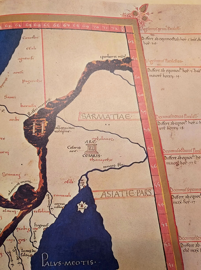
Fig. 5. Ptolemaios Klaudios, CodVat VF32. Focus on the temple (?) at 58 degrees N.
5 pav. Ptolemajas Klaudijas, CodVat VF32. Dėmesys į šventyklą (?) ties 58 laipsniais šiaurės platumos
Concluding remarks
In conclusion, archaeology, notably the evidence of travelling tradesmen in the Baltic in the Bronze and Iron Age, indirectly supports the idea of Pytheas the Massaliot exploring the Baltic as do the disparate written sources. This would, among the ancients, place Pytheas in the same category as Kolaios of Samos, Aristeas of Proconessus and Hanno of Carthage, all heading wide ranging expeditions searching for trade, resources and the end of the oikoumene as it was known to them. Further, the Homeric allusions in the corpus of Pytheas the Massaliot also seems fitting for a true travelling trader exploring the world as never before. That he backed his discoveries and allusions with remarkably precise factual information is our luck today since we are able to confirm or make probable most of his observations.
Based on this I here propose a journey of Pytheas the Massaliot that went into the Baltic along 54 degrees north (fig. 6), a parallel Pytheas would have known through his parallel taken at either Morecambe Bay, Flamborough Head or the mouth of the Elbe, and then northwards to Saaremaa at 58 degrees north, again a parallel he already knew from measuring it at Cape Wrath (fig. 3). The very precise parallels taken at 48, 54 and 58 degrees north, where two are confirmed by the solar height at the winter solstice present hard facts anchoring the other evidence as does the solar height coupled with 19 equinoctal hours at summer soltice at Shetlands and the 20 equinoctal hours and 11,500 stades north of Massalia at the Faroes.
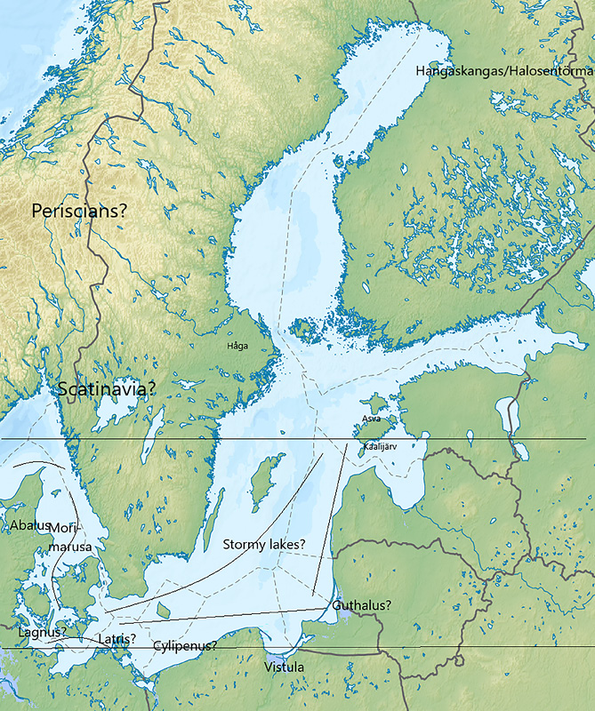
Fig. 6. Pytheas in the Baltic? With probable identifications of names from the Pythean corpus and important archaeological sites mentiones in the text.
6 pav. Pitėjas Baltijos jūroje? Žemėlapis su identifikuotomis ir pažymėtomis Pitėjo nurodytomis vietovėmis ir pavadinimais ir svarbiomis archeologinėmis vietovėmis, minimomis tekste
In conclusion. It is possible to argue that Kaali on Saaremaa was visited by Pytheas the Massaliot, that he knew it as the “place where the sun went to bed” and that the myth of the fall of Phaethon is a reflection of the meteorite impact a millenium before.
This reconstruction lacks the strong corroborating archaeological and ethnographical evidence that makes it a lot easier to chart Pytheas’ journey as far as Abalus, but the journey further east is plausible and while the archaeological and written evidence are more ambiguous it is by no means an implausible reconstruction. It makes archaeological as well as geographical sense.
It is no wonder that some in the ancient world had a hard time believing in this tall tale, since it was also used in a fantastical novel called “On the Hyperboreans” by Hekataios of Abdera not much later than Pytheas in date and in the Roman Imperial period by Antonios Diogenes in “On the wonders beyond Thule”.
Bibliography
Arcelin P. 1992. Société indigene et propositions culturelles massaliotes en basse Provence occidentale. Marseille grecque et la Gaule, Collection Etudes Massalietes, 3, p. 305–336.
Bianchetti S. 2008. Geografia e Cartografia dell’estremo occidente da Eratostene a Tolemeo. Mainake, XXX, p. 17–58.
Bianchetti S. 2020. Traces of scientific geography in Pliy’s Naturalis Historia. Steps, T6, 1, p. 10–25.
Bilić T. 2012. Crates of Mallos and Pytheas of Massalia: Examples of Homeric Exegesis in Terms of Mathematical Geography. Transactions of the American Philological Association, 142/2, p. 295–328.
Bilic T. 2020. Pytheas and Hecataeus: Visions of the North in the Late Fourth Century BC. Greek, Roman and Byzantine Studies, 60, p. 574–593.
Bizot B. & al. 2007. Marseille antique. Paris: Editions du Patrimonie, Guides archéologiques de la France.
Clarke K. 1999. Between Geography and History: Hellenistic Constructions of the Roman World. Oxford.
Clavel-Leveque M. 1977. Marseille grecque. Le dynamisme d’un impéralisme marchand. Marseille: Editions Jeanne Lafitte.
Cunliffe B. 2001. The Extraordinary Voyage of Pytheas the Greek. London.
Cunliffe B. & Galliou P. 2004. Les fouilles du Yaudet en Ploulec’h, Cotes-d’Armor. Oxford: Oxford University School of Archaeology Monograph.
Dicks D. R. 1960. The Geographical Fragments of Hipparchus. London: University of London / The Athlone Press.
Dietler M. 2009. Colonial Encounters in Iberia and the Western Mediterranean: An Exploaratory Framework. M. Dietler and C. Lopez-Ruiz (eds.) Colonial Encounters in Ancient Iberia, Phoenician, Greek and Indigenous Relations. Chicago: University of Chicago Press, p. 3–48.
Englert A. 2012. Travel Speed in the Viking Age: Results of Trial Voyages with Reconstructed Ship Finds. N. Günsenin (ed.) Between Contintents. Proceedings of the Twelfth Symposium on Boat and Ship Archaeology Istanbul 2009. Istanbul, p. 269–278.
Erikssson T. 2022. Keramiken berättar om Håga. T. Zachrisson, I. Ullén & M. Olausson (eds.) Håga. Gravhögen och bygden från Bronsålder til Nutid. Uppsala, p. 110–128.
Fabre P. 1981. Les Grecs et la connaissance de L’Occident. Lille.
Fernandez-Götz M. 2018. Urbanization in Iron Age Europe: Trajectories, Patterns and Social Dynamics. Journal of Archaeological Research, 26, p. 117–162.
Fischer C. et al 2016. The multiple maternal legacy of the Late Iron Age group of Urville-Nacqueville (France, Normandy) documents a long-standing genetic contact zone in northwestern France. PlosOne, 13/12, e0207459. Available at: https://www.ncbi.nlm.nih.gov/pmc/articles/PMC6283558/
Gulbekian E. 1987. The Origin and Value of the Stadion Unit used by Eratosthenes in the Third Century BC. Archive for History and Exact Sciences, 37/4, p. 357–363.
Haas A. et al. 2004. Echoes of Ancient Cataclysms in the Baltic Sea. Folklore, 23, p. 49–81.
Hawkes C. F. C. 1978. Pytheas: Europe and the Greek Explorers, 8th. J. L. Myres Memorial Lecture, Oxford.
Hermary A. et al. 1999. Marseille grecque 600-49 av. J.-C. La cite Phocéenne. Paris.
Hermary A. & Tréziny H. 2015. Artémis d’Éphèse, de Marseille à Arles. E. Okan & C. Atila (eds.) Studies in Honour of Ömer Özyiğit. Eistanbul, p. 237–246.
Heidel W. A. 1937. The Frame of the Ancient Greek Maps with a Discussion of the Discovery of the Sphericity of the Earth. New York.
Herva V.-P. et al. 2022. An odyssay to golden mica – contextualising the burial of a bronze age “Odysseus”. Oodeja Mikalle - Odes to Mika - Оды Мике: Festschrift for Professor Mika Lavento on the Occasion of his 60th Birthday. Monographs of the Archaeological Society of Finland 10, p. 86–92.
Horst Roseman C. 1994. Pytheas of Massalia: On the Ocean. Text, Translation and Commentary. Chicago: Ares Publishers Inc.
James P. & van der Sluijs M. A. 2016. The fall of Phaethon in Context : A New Synthesis of Mythological, Archaeological and Geological Evidence. Journal of Ancient Near Eastern Religions, 16, p. 67–94.
Jensen J. 2003. Danmarks Oldtid. Ældre Jernalder. Gyldendal, København.
Jensson G. 2018. Sailing from Massalia, or Mapping Out the Significance of Encolpius’ Travels in the Satyrica. F. Montanari and A. Rengakos (eds.) Cultural Crossroads in the Ancient Novel. Trends in Classics – Supplementary Volumes. Volume 40, Walter de Gruyter, Berlin, p. 7–16.
Jones A. 2017. A Portable Cosmos – Revealing the Antikythera Mechanism, Scientific Wonder of the Ancient World. Oxford: Oxford University Press.
Kähler F. 1903. Forschungen zu Pytheas’ Nordlandsreisen. Max Niemeyer Verlag, Halle.
Katzev M. 1987. An Analysis of the Experimental Voyages of Kyrenia II. H. Tzalas (ed.) Tropis. 2nd International Symposium on Ship Construction in Antiquity. Delphi, p. 245–256.
Kaul F. & Martens J. 1995. Foreign South Eastern Influences in Denmarks Early Iron Age. Acta Archaeologica, 66, p. 111–161.
Künzl S. 1997. Musov – Zu kostbaren Beigaben in germanischen Gräbern des frühen Kaiserzeit. C. Bridger and C. von Carnap-Bornheim (eds.) Römer und Germanen. Nachbarn über Jahrhunderte. BAR International Series 678, Oxford, p. 37–42.
Lehmann-Haupt K. 1929. “Stadion (Metrologie)”. Paulys Realencyklopädie der Klassischen Altertumswissenschaft III A,2. Sparta-Stluppi. Stuttgart, col. 1931–1963.
Leigemann D. et al. 2005. Zum aniken astro-geodätischen Messinstrument Skiothérikos Gnomon. Zfv, 4, p. 238–246.
Lewis M. 2001. Surveying Instruments of Ancient Greece and Rome. Cambridge: Cambridge University Press.
Lewis M. 2012. Greek and Roman Surveying and Surveying Instruments. R. J. A. Talbert (ed.) Ancient Perspectives. Maps and their place in Mesopotamia, Egypt, Greece and Rome. Chicago : University of Chicago Press, p. 129–162.
Losiak A. et al. 2016. Dating a small impact crater: An age of Kaali crater (Estonia) based on charcoalemplaced within proximal ejecta. Meteoritics & Planetary Science, 51/4, p. 681–695.
Lougas V. 1978. Von der vorlaufigen Datierung der Burg Kaali. Toimetised, 27, p. 327–329.
Lougas V. 1980. Archaeological Excavations in the Kaali Crater Area. Toimetised, 29, p. 357–359.
Luik H. & Ots M. 2007. Bronze Age Double Buttons in Estonia. Estonian Journal of Archaeology, 11/2, p. 122–140.
Lynch P. 2013. Irelands fractal coastline. (Available at: Ireland’s Fractal Coastline | ThatsMaths).
Mägi M. 2004. Article Comment: Echoes of Ancient Cataclysms in the Baltic Sea. Folklore, 23, p. 82–85.
Mandelbrot B. 1967. How long is the coast of Britain? Statistical self-similarity and fractal dimension. Science, 156, p. 636–638.
McKinley J. et al. 2017. Dead-Sea Connections: A Bronze Age and Iron Age Ritual Site on the Isle of Thanet. J. T. Koch and B. Cunliffe (eds.) Celtic from the West 2. Oxford, p. 157–184.
Meri L. 1976. Hõbevalge. Tallinn, esti Raamat.
Mittenhuber F. 2003. Die Naturphänomene des hohen Nordens in den kleinen Schriften des Tacitus. Museum Helveticum, 60, p. 44–59.
Morel J. P. 2006. De Marseille à Velia: problèmes phocèens. Comptes Rendus de Acadèmie des Inscriptiones et Belles-Lettres, 2006/4, p. 1723–1786.
Paavel K. et al. 2019. Three Bronze Axes with wooden Haft remains from Estonia. Estonian Journal of Archaeology, 23, p. 3–19.
Pape J. 2000. Die Attische Keramik der Heuneburg und der keramische Südimport in der Zone nördlich der Alpen während der Hallstattzeit. W. Kimmig (ed.) Importe und Mediterrane Einflüsse auf der Heuneburg. Heuneburgstudien XI. RGZM, p. 71–176.
Popham M. R. & Lemos I. S. 1996. Lefkandi III: the Toumba Cemetery. The Excavations of 1981, 1984, 1986 and 1992-4. BSA Suppl., vol. 29, Oxford.
Py M. & Tréziny H. 2013. Massalia – de l’archéologie á l’histoire. I. Bats (ed.) D’un monde a l’autre. Contacts et acculturation en Gaule mediteranée. Centre Jean Berard.
Rae A. 2016. How long is the coastline of Great Britain? (Available at: http://www.statsmapsnpix.com/2016/08/how-long-is-coastline-of-great-britain.html?m=0.)
Rasch G. 1950. Antike geographische Namen nördlich der Alpen. Dissertation. Herausgegeben 2005, Stefan Zimmer, Walter de Gruyter. Berlin.
Rasmussen K. L. et al. 2000. The age of the Kaalijärv meteorite craters. Meteorites & Planetary Science, 35, p. 1067–1071.
Riis P. J. 1959. The Danish Bronze Vessels of Greek, Early Campanian and Etruscan Manu-factures. Acta Archaeologica, 30, p. 1–50.
Roller D. 2006. Through the Pilllars of Herakles. Greco-Roman exploration of the Atlantic. Routledge.
Romano D. 1993. Athletics and Mathematics in Ancient Corinth. The Origins of the Greek Stadion. Philadelphia: Memoirs of the American Philosophical Society.
Shcheglov D. 2007b. Ptolemy’s Latitude of Thule and the Map Projection in the pre-Ptolemaic Geography. Antike Naturwissenschaften und ihre Rezeption, p. 1–31.
Schmitt A. 1876. Zu Pytheas von Massalia. Landau.
Sideris A. 2021. Situlae with palmettes: Vratsa, Waldalgesheim and the Vagaries of a Motif. Ancient West & East, 20, p. 21–50.
Small M. 2007. From jellied seas to open waterways: redefining the northern limit of the knowable world. Renaissance Studies, 21/3, p. 315–338.
Sommer L. 2019. Echoes of Invented Pasts: Ethnic Self-Images in Estonian Culture. Y. Kalogeras and C. C. Waegner (eds.) Performance, Literature and Identity. New York: Routledge, p. 204–219.
Sperling U. 2014. Aspects of change in the bronze age eastern Baltic. The settlements of the Asva group in Estonia. Estonian Journal of Archaeology, p. 394–401.
Sperling U. et al. 2020. Ausgrabungen in Asva im Jahr 2020 – Auf den Spuren des Bronzegiesserplatzes. Archaeological Fieldwork in Estonia, p. 53–64.
Steensby H. P. 1918. Pytheas fra Massilia og Jyllands Vestkyst. Geografisk Tidsskrift, 24/1, p. 12–34.
Talvik R. 2015. Teekond maailma ääreni. Kuidas kreeklane Pytheas oma imelisel teekonnal 2300 aastat tagasi Eestimaalt Ultima Thule avastas. Director Meedia.
Tillisch S. S. 2009. Oldtidsforfattere under arkæologisk kontrol – Om skriftlige kilder og materiel kultur i Sydskandinavien. Kuml, 58, p. 213–240.
Tréziny H. 1989. Questions de métrologie architecturale massaliète. Revue archéologique narbonnaise, 22, p. 1–46.
Tréziny H. 2009. Marseille Antique. Topographie, Urbanisme, Architecture. Empuries, 56, p. 41–54.
Van den Boom H. & Pape J. 2000. Die Massaliotischen Amphoren. W. Kimmig (herausg.) Importe und Mediterrane Einflüsse auf der Heuneburg. Heuneburgstudien XI. RGZM, p. 43–70.
Vennemann T. 2006. The name of the Isle of Thanet. A. J. Johnstone (ed.) Language and Text: Current Perspectives on English and Germanic Historical Linguistics and Philology. Heidelberg.
Veski S. et al. 2001. Ecological catastrophe in connection with the impact of the Kaali meteoriet about 800–400 BC on the island of Saaremaa, Estonia. Meteoritics and Planetary Science, 36, p. 1367–1375.
Veski S. et al. 2004. The age of the Kaali meteorite craters and the effect of the impact on the environment and man: evidence from inside the Kaali craters, island of Saaremaa, Estonnia. Vegetational History and Archaeobotany, 13, p. 197–206.
Viedebant O. 1915. Eratosthenes, Hipparchos und Poseidonios. Ein Beitrag des Erdmessungsproblem im Altertum. Klio, 14, p. 207–256.
Wolska-Konus W. 1968. Cosmas Indicopleustes. Topographie chrétienne, tome I Introduction et livres I–IV. Paris: Centre National de la Recherche Scientifique.