Archaeologia Lituana ISSN 1392-6748 eISSN 2538-8738
2022, vol. 23, pp. 195–217 DOI: https://doi.org/10.15388/ArchLit.2022.23.12
Urbanization the Eastern Borders of Old Europe
Mykhailo Videiko
Department of Archaeology and Old History
Kyiv Borys Grinchenko University
13b Levka Lukianenka St., Kyiv, Ukraine
e-mail: my.videiko@kubg.edu.ua
Abstract. Maria Gimbutas created an impressive picture of Old Europe, using, among others, materials from Trypillia Culture. From the very beginning, she took into account new archaeological discoveries from the 70s of the 20th century, namely, information about the large settlements. But fifty years ago, their studies were just beginning and this topic was not particularly popular among researchers outside of Ukraine. Today, news about life on the eastern borders of Old Europe, where these megasites, appeared more than 6000 years ago, appeares on the pages of leading archaeological publications and becomes the subject of discussions among archaeologists from different countries.
Keywords: Prehistory, Old Europe, Cucuteni, Trypillia, megasites, urbanization.
Senosios Europos rytiniai pakraščiai
Anotacija. M. Gimbutienė sukūrė įspūdingą Senosios Europos paveikslą, be kita ko, naudodama Tripolės kultūros medžiagą. Ji pasitelkė XX amžiaus septintojo dešimtmečio archeologinius atradimus, ypač informaciją apie dideles gyvenvietes. Tačiau prieš penkiasdešimt metų tokie tyrimai dar buvo tik prasidėję, tad ši tema nebuvo populiari tarp tyrinėtojų už Ukrainos ribų. Šiandien naujos žinios apie gyvenimą rytinėse to meto Senosios Europos teritorijose, kur tokie megaobjektai egzistavo jau daugiau nei prieš 6000 metų, yra žinomiausių archeologinių leidinių puslapiuose ir tapo įvairių šalių archeologų mokslinių diskusijų objektu.
Reikšminiai žodžiai: priešistorė, Senoji Europa, Kukutenis, Tripolė, megaobjektai, urbanizacija.
____________
Received: 07/11/2022. Accepted: 17/11/2022
Copyright © 2022 Mykhailo Videiko. Published by Vilnius University Press. This is an Open Access article distributed under the terms of the Creative Commons Attribution License, which permits unrestricted use, distribution, and reproduction in any medium, provided the original author and source are credited.
Introduction
Since 2009 few important international research projects, related to Cucuteni–Trypillia, started in Ukraine and Moldova. They not only gave a number of important discoveries, but also significantly expanded the circle of researchers of Cucuteni–Trypillia culture by archaeologists from Great Britain and Germany.
As it was in 1971–1993, archaeologists used “the complex method” of investigations, which included satellite images (instead of aerial survey in 70s), large-scale magnetic prospection, archaeological methods and archaeometry (Chapman et al., 2014; Videiko, 2021, 306–317).
The Ukrainian-British project in 2009–2015 was dedicated to the study of a large settlement near the village of Nebelivka and its surroundings. It included a magnetic survey of the settlement in Nebelivka, as well as the excavation of several objects (At the eastern frontiers, 2015; Chapman et al., 2020).
The Ukrainian-German project in 2011–2019 covered the territory between the Dniester and Southern Bug rivers (Rud et al., 2019a; 2019b), as well as a large area around the Maidanetske settlement . A significant amount of magnetic surveying was carried out, which covered several dozen settlements, and excavations were carried out both in Maidanetske and in a number of large and small settlements (Müller et al., 2016b; Ohlrau, Rud, 2019).
The Moldova-German project started at 2009 covered few areas at the North of Moldova. Investigations started at Petreni (Uhl et al., 2014) and continued at Stolniceni 1 (Ţerna et al., 2016). Also a significant amount of magnetic surveying was carried out at sites of different size.
Thanks to these efforts, information was obtained that significantly changed the perception of the nature of huge settlements, their economy, architecture, social organization, and history for almost 800 years. The news can be grouped in several areas: planning of settlements and their development, fortifications, craft complexes, public buildings, economy.
Environment and its influence on the situation
An unprecedented amount of work has been carried out on the study of the natural environment of the era of mega-sites (Dal Corso et al., 2018; Dal Corso et al., 2019; Dreibrodt et al., 2020; Albert et al., 2020). This made it possible to get a picture of the dynamics of its changes. This is necessary for various aspects of the reconstruction of their history during the almost thousand-year period from their appearance to their decline.
The assumptions made earlier about anthropogenic influences, in particular, the large-scale destruction of forests in the vicinity of megasites, have been confirmed. At the same time, it became clear that there was also a process of vegetation recovery, so the consequences of the use of forest resources were not as catastrophic as previously thought.
Among recent discoveries is the establishment of the fact of the use of organic fertilizers in field farming. This happened thanks to the study of the diet of domestic animals from the Maidanetske settlement. It was established that they were fed with grain grown on fertilized fields. In this way, significant corrections have been made to the perception of the possibility of population concentration in mega-sites (Makarevich et al., 2022, 831–847).
The prosperity of megasites also needed an explanation in view of the collapse of cultural complexes in South-Eastern and partly Central Europe after 4200 BC. It was caused by climatic changes, which caused a crisis in agriculture in the specified region (Wenninger, Harper, 2015, 418–515). It seemed that the Cucuteni–Trypillia cultural complex had to suffer accordingly. But the archaeological data, on the other hand, testify to its flourishing, the manifestation of which was the appearance of mega-sites after 4200 BC.
Information about the natural environment of the mega-sites proves that the period of their existence up to 3600–3500 BC was marked by exceptionally favorable natural conditions. That is, the eastern part of “Old Europe”, in contrast to the western part, experienced an economic, demographic, and social boom between 4200–3600 BC precisely due to favorable climatic conditions.
Рlanning of settlements and their development
After 2007, researchers from scientific institutions of Great Britain, Germany and Romania were at the sights of Cucuteni–Trypillia and used a more advanced technique, which made it possible to perform significant volumes of work and create more accurate archaeological plans of objects (fig. 1–2; 5). This technique was produced in Great Britain and Germany, had different parameters, differed in the number of sensors, etc. (Chapman et al., 2014; Rassmann et al., 2014, 99–112; Asăndulesei, 2017; Asăndulesei et al., 2020).
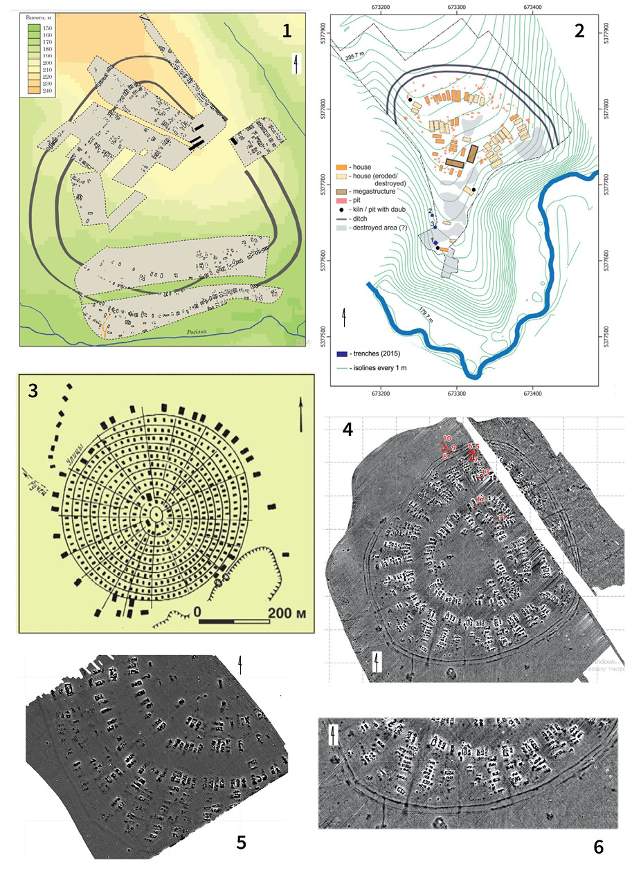
Fig. 1. Plans of Trypillia Culture sites: 1 – Bilyi Kamin (after Rud et al., 2019); 2 – Vijtivka (after Rud et al., 2017); 3 – Petreni, airphoto (after V. Markevich); 4, 6 – Stolniceni (Terna et al., 2016); 5 – Petreni (after K. Rassmann).
1 pav. Tripolės kultūros gyvenvietės: 1 – Bilyi Kamin (pagal Rud et al., 2019); 2 – Vijtivka (pagal Rud et al., 2017); 3 – Petreni, aeronuotrauka (pagal V. Markevich); 4, 6 – Stolniceni (Terna et al., 2016); 5 – Petreni (pagal K. Rassmann)
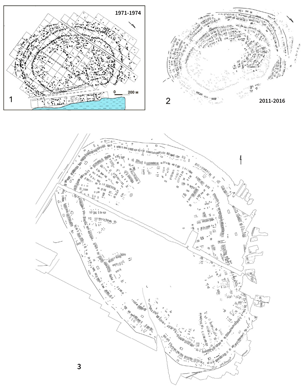
Fig. 2. Plans of Trypillia Culture sites: 1 – Maidanetske, old plan, 1971-74; 2 – Maidanetske, new plan, 2011-16; 3 – Nebelivka.
2 pav. Tripolės kultūros gyvenviečių planai: 1 – Maidanetske, senas planas, 1971–1974; 2 – Maidanetske, naujas planas, 2011–2016; 3 – Nebelivka
If we will put together the results of geophysical research conducted at the sites of the cultural complex of Precucuteni–Cucuteni–Trypillia after 2000 in the territories of Romania, Moldova and Ukraine, we will see that during this period they covered about 80 sites (Videiko, 2021, 306–313). This is almost twice as much as was done in 1971–1994, when plans for 43 sites were made. However, it should be remembered that the total number of available plans is still only near 3% of the identified sites.
A great number of new plans was obtained, as well as re-surveying was carried out in such settlements as Maidanetske, Talyanky, Hlybochok and others (fig. 2). The repeated survey brilliantly confirmed the results of the magnetic survey conducted by Valeriy Dudkin before and were available to Maria Gimbutas at the time . However, the use of new generation equipment made it possible to open new facilities and specify the number of structures in the settlements.
Thanks to research in the interfluve of the Dniester and Southern Bug rivers, there were discovered several large settlements with a planning system that included internal and external rows of buildings, separated by a space free from development (Rud et al., 2019, fig. 2–13). This space planning which was known before only in Southern Bug– Dnieper interfluve, created conveniences for communication within the settlement, and also provided an additional area within the perimeter protected by fortifications. Earlier, it was suggested that it could also have a defensive significance, as an esplanade in front of the fortifications of the internal buildings.
To the west of the Dniester, at about the same time, another tradition was formed, namely the planning of large settlements in the form of a regular circle, like Stolniceni 1 and Petreni (Ţerna et al., 2016; Uhl et al., 2014). It means that existed two different traditions of megasites planning for West and East of Cucuteni–Trypillia (fig. 1).
The location of large public buildings around the perimeter of the settlements in both cases can testify to the fact that both traditions are somehow connected with each other (fig. 1–2). At the same time, the custom of building a complex of the largest public buildings in the eastern sector of the settlement is forming in the east. Common to the west and east is the grouping of buildings into clusters of several buildings within the planning structures.
More sophisticated equipment has provided more accurate information for separating anomalies into separate parts that correspond to the remains of individual structures, as well as detecting low anomalies from the remains of buildings that were not previously detected. For this reason, the number of remaining buildings has increased dramatically for previously investigated settlements.
Thus, instead of 1575 anomalies, it was possible to identify about 2900 anomalies in the field of about 200 hectares in Maidanetske (fig. 2, 1–2). This means that all previous calculations regarding the likely population of this megasite should be revised (Muller et al., 2016b).
Close to this problem was the discovery by magnetic survey of the so-called “probable houses” at different sites. For example, anomalies, named as “probable houses”, counted up to twenty-one per cent of the remains of houses at Nebelivka (Rud, 2015, 26). In 2013, this feature was partially explored with a 1 × 4 m test-pit in the outer row of houses, when some broken pots and small fragments of burnt daub were found. In the 2014 season, the larger area here was investigated (Rud, 2015, 26–27). The remains of dwellings were discovered at a depth of 0.4–0.5 m from the contemporary surface. They formed close to rectangular structures, created by small fragments of burnt daub, broken pottery, including different kinds of vessels, stones, and clay platforms on the ground floor – destroyed elements of the interior (fig. 5–6).
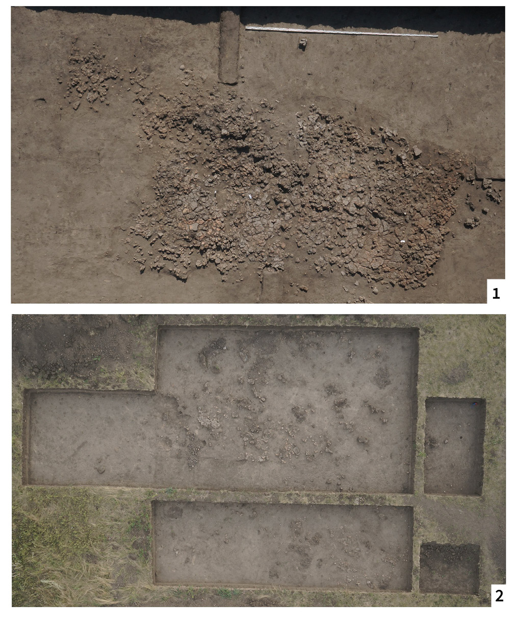
Fig. 3. Remains of Trypillia Culture burnt houses: 1 – totally burnt, large anomaly (Maidanetske, 2014); 2 – partly burnt, low anomaly (Nebelivka, 2014).
3 pav. Tripolės kultūros sudegusių pastatų liekanos: 1 – visiškai sudegęs, didelė anomalija (Maidanetske, 2014); 2 – iš dalies sudegęs, nedidelė anomalija (Nebelivka, 2014)
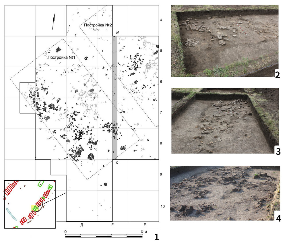
Fig. 4. Excavations of partly burnt houses at Nebelivka (after Rud, 2015): 1 – plan of explored area; 2–4 – remains of burnt houses and pottery finds.
4 pav. Iš dalies sudegusių pastatų Nebelivkoje kasinėjimai (pagal Rud, 2015): 1 – tyrinėtos teritorijos planas; 2–4 – degusių pastatų liekanos ir keramikos radiniai
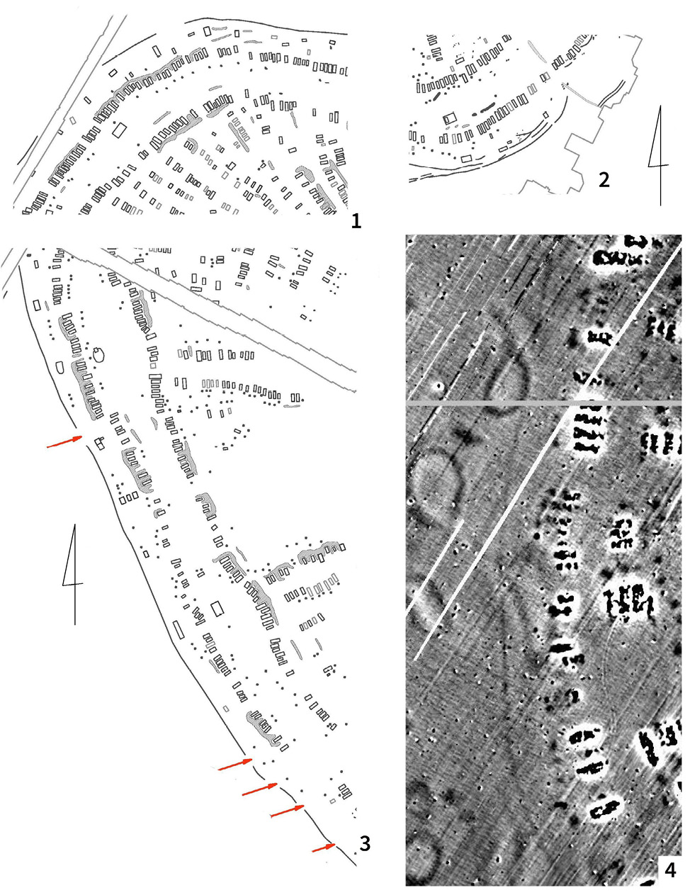
Fig. 5. Trases of palisades on plans of the mega-sites: 1–3 – Nebelivka (possible entrances marked by red arrows); 4 – Maidanetske.
5 pav. Megaobjektų tvorų pėdsakai planuose: 1–3 – Nebelivka (galimi pėdsakai pažymėti raudonomis rodyklėmis); 4 – Maidanetske
Fig. 6. Excavations of the palisade ditch at Nebelivka: 1 – view of trench from drone; 2 – plan of site with traces of palisade; 3 – cross-section of palisade ditch; 4 – contours of the ditch marked by red.
6 pav. Nebelivkos tvoros griovio tyrimai: 1 – tranšėjos vaizdas iš drono; 2 – gyvenvietės planas su tvorų pėdsakais; 3 – tvoros griovio skersinis pjūvis; 4 – raudonai pažymėti griovio kontūrai
From house 1 originated no less than nineteen items: a bowl, a semi-spherical bowl, six goblets, seven bi-conical vessels, a pear-like vessel, a pot, and two ‘kitchen pots’ – no less than from the normal (and larger) houses A9 and B17, as described before. The situation with storage vessels was the same. The character of pottery burning, its distribution and deposition, the amount of burnt daub (with admixture of plants), and pieces of slag-like daub provided clear evidence that these two features in this area were burnt, as occurred to other houses to the left and to the right of this place. It is possible to suppose that the amount of burnt daub in such a case depends on (a) the amount of clay used for construction of the house; (b) the process of burning, different here from the surroundings. The last feature is similar to central part of the megastructure (dwelling B5) investigated in 2012. So, there is now a reason to examine all the remains of this type of building as objects left without burning or as some different phase of site development.
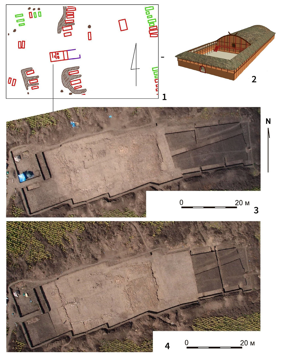
Fig. 7. Nebelivka, mega-structure: 1 – megastructue on plan of the site; 2 – reconstruction of mega-structure (by M. M. Videiko); 3–4 – different stages of excavations.
7 pav. Nebelivka, megastruktūra: 1 – megastruktūra gyvenvietės plane; 2 – megastruktūros rekonstrukcija (M. M. Videiko); 3–4 – skirtingi tyrimų etapai
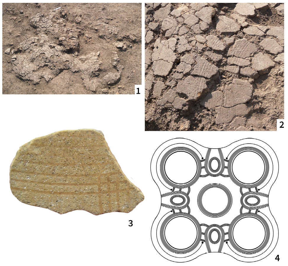
Fig. 8. Nebelivka, mega-structure, one from 7 altars: 1 – after excavations; 2 – part with traces of decorations; 3 – piece of altar with decoration after cleaning (after S. Fedorov); 4 – reconstruction of decoration of altar (after S. Fedorov).
8 pav. Nebelivka, megastruktūra, vienas iš septynių altorių: 1 – po kasinėjimų; 2 – dalis su ornamentikos pėdsakais; 3 – dalis altoriaus su puošybos elementais nuvalius (pagal S. Fedorov); 4 – altoriaus dekoro rekonstrukcija (pagal S. Fedorov)
On the other hand, the magnetic mapping of the Nebelivka settlement proved that it is impossible to extrapolate the building density established for one settlement to others. After all, about 1,400 anomalies were found here on an area of more than 235 hectares – half as many as on 200 hectares in Maidanetske (compare fig 2, -2 and fig. 2–3). This example leads to the conclusion about the need for an individual approach to each megasite when calculating the likely population size. The simultaneous existence of residents in the settlement remains a separate issue, which deserves separate consideration.
Internal chronology of megasites
The synchronicity or asynchrony of most of the dwellings is key to the interpretation of this phenomenon. For a long time, the main means were the comparison of pottery complexes and stratigraphy. They proved the high probability of coexistence of the majority of residents at the final stage of the life of the settlement. At the same time, it became clear that the cases of stratigraphy testify to certain stages in the construction of these points and show that they could grow in size gradually (Videiko, 2013, 88–97).
When drawing up new research programs, it was decided to solve these issues at the expense of mass isotopic dating of objects. More than 250 determinations were made for only two settlements – Nebelivka and Maidanetske (Millard, 2020, 246–265; Muller et al., 2016a, 136–152; Müller et al., 2022, 95–96). This is comparable with all dates that existed for the entire Cucuteni–Trypillia cultural complex at that time.
But the obtained results proved that isotopic dates cannot yet be an independent source for solving this issue. In many cases, they came into complete contradiction with archaeological materials and stratigraphic observations. There are several reasons for this state of affairs.
The first is that even this number of dates is not enough to develop an internal chronology of the settlement. From each object, it is necessary to have at least 6 dates for this. In case with Nebelivka site, in practice, this number did not exceed 2–3, and only in some cases reached 5. Next, when selecting samples for dating, and these were mainly animal bones, the materials were taken from different species, not one. This led to differences in the dates, as each of the species has its own diet and accordingly differs in the accumulation of elements in the bones, which affects the results obtained (Muller et al., 2022, 95–96).
The next problem was that the dates from the bone samples were compared with the dates on the charcoal, as they have their own dynamics of natural processes. It should be added that in the case of Nebelivka, there was a small amount of collagen in the bones. One of the reasons for this could be the existence of increased radioactivity in this area due to deposits of uranium ores. As a result, a fantastic picture of the existence of the megasite Nebelivka for more than 500 (Müller et al., 2022, fig.1) or 200 years (Albert et al., 2020, 25) was obtained, which does not correspond to real archaeological data.
The experience gained in this way shows that for the productive application of the isotopic dating method in the study of the internal chronology of megasites, it is necessary to solve a number of problems, of which the selection of the necessary number of certain samples is the competence of archaeologists, and the work with them is the responsibility of laboratories. The latter should also participate in the generalization of the obtained results, giving the necessary explanations.
At the same time, the combination of better magnetic plans of settlements with archaeological excavations made it possible to more realistically assess their internal chronology. In particular, earlier and later objects were identified on the plan and then recorded during the excavations in Maidanetske (fig. 2, 2 – on top; fig. 9, - 2). This made it possible to talk about certain stages in the development of the settlement, which could last about 200 years. It is worth noting that these observations were generally confirmed by isotopic dates.
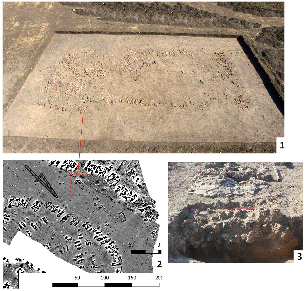
Fig. 9. Maidanetske, excavations of smaller mega-structure: 1 – view from drone; 2 – part of plan with mega-structure. Close to it is visible area with older houses and pits; 3 – pit with remains of burnt house under altar.
9 pav. Maidanetske, mažesnės megastruktūros kasinėjimai: 1 – vaizdas iš drono; 2 – plano dalis su megastruktūra. Šalia matyti teritorija su senesniais pastatais ir duobėmis; 3 – duobė su apdegusio pastato liekanomis po altoriumi
Given the existing information, the conclusion remains that most buildings on the megasite existed at the same time. The duration of existence of each of them could be up to 100, and in some cases up to 200 years. In view of this, the issue of internal chronology should be decided separately for each of the megasites and taken into account in further reconstructions.
Demography and development of megasites
Changes in information about the number of buildings in settlements and the probable number of those that existed at the same time opened the possibility to revise the reconstruction of the population of megasites. Previously, for example, figures from 7,000 to 9,000 people were calculated for Maidanetskе (Shmaglij, Videiko, 1993) and up to 14,175 for Taljanky (Kruts, 1989).
New calculations made on the basis of the updated plan of Maidanetske in 2016 were made taking into account 14C dating of a number of buildings in various structures of the settlement. The estimated population of Maidanetske was “under conservative estimations, to about 12,000 inhabitants, with an improbable maximum of about 46,000 inhabitants and a probable average of 29,000 inhabitants” (Mueler et al., 2016, p. 164). However, these indicators were recognized as “maximum”. According to the assumption that not all buildings, which are taken into account according to the plan, functioned at the same time (and this was discovered by excavations in the 80s and confirmed by research in 2013–2016), it is recognized that a more probable number could be from 8,500 to 14,500 people. Another method of calculations, applied to the same information, gave higher indicators: 22,300–23,800. For other megasites, such as Dobrovody, the estimate was 14,100–16,200, for Taljanky 15,600–21,000 (ibid., p. 164).
As you can see, with different methods of calculation and changing the set of information about the megasites themselves, the results for 40 years revolve around numbers from 7 to 15 and even more thousands of people. At the same time, new information, including that obtained when applying the most modern methods, does not change this trend in any way. On the contrary, they lead to obtaining more “extreme” indicators than it was before. In addition, in any case, these indicators go beyond traditional ideas about the number of inhabitants of Neolithic settlements in Europe.
It was mentioned above that the new information about the agriculture of the inhabitants of the megasites confidently indicates the probability of such a concentration of the population. Note that even with a lower level of agricultural technology in Neolithic Europe, it was already possible to feed up to 16,000 people in one place. So we can see that it probably took place around 4000 BC. However, calculations regarding the productivity of Neolithic agriculture also showed that it enabled 30 farmers to support up to 70 people. In case of megasites it implies division of labor (Shukurov et al., 2015).
If in the case of small settlements this had the consequence to population growth, then in the case of megasites there should have been other consequences besides this. If the above calculations regarding labor productivity in agriculture are correct, then under conditions of concentration of 10,000 people in one place, the number of farmers should be 3,000. Let even half of the remaining 7,000 be unable to work (young children, sick, elderly, etc.) and we have more than 3,000 people who could have been involved in other fields of activities – from crafts and large-scale construction of houses and other structures to trade, military affairs, administration, etc. It is precisely these consequences of population concentration in megasites that we probably observe in the archaeological data. We are talking about discovered public buildings – temples, large-scale fortifications, professional pottery kilns, which will be discussed below.
Fortification of settlements
Thanks to magnetic surveying, it was possible to identify fortifications in most megasites, as well as parts of medium-sized settlements (fig. 5–6). At the beginning all of them were identified as the traces of ditches, but after investigations it was realized, that some of them were traces of palisades.
Such objects were excavated at Nebelivka and Maidanetske. Traces of the ditch were detected around the site as lines of width 3–4 m. In Nebelivka two small sections of this structure were explored: one at the North and one at the South (fig. 5, - 1–3). The first revealed one line of anomalies, and the second revealed three lines of anomalies. The traces of the ditch were clearly visible in profile (fig. 6, - 2–3). This ditch was 3–4 m wide at top and 0.4–0.6 m at the bottom. The total depth of ditch, estimated from the ancient horizon, was around 0.8–0.7 m. The dark fill of this depression was the mixed soil, rather than the fill of an open ditch. In this fill and around it, a few small fragments of pottery and burnt daub were found.
The southern ditches were explored with a 2-m wide trench. The traces of these features were not so clearly visible, but the trench was located close to places determined by geomagnetic prospection. Only one thing was clear – they were not as deep as those in the North and they were no wider than 1 m. The features were located on a slope, so it is possible that the top part of soil here was damaged by erosion.
Explorations in both trenches confirmed the presence of the ditch, but revealed it to be smaller than previously supposed. There are two points of view on this feature. The first – that it was a small ditch, some symbolic border/enclosure of the settlement (J. Chapman). The second – it was a ditch, which was made for the construction of palisades (M. Videiko) with secondary using of timber of it at the final stage of its existence. The character of its fill (mixed soil) supports this interpretation.
In Maidanetske were explored remains of a similar ditch of small depth (0.8 m) and mixed filling. In this case the line of palisade was removed at the stage, when the next lines of houses were erected from the field side and area of the site was extended (fig. 2, - 2; fig. 5, - 4). The similar thing happened at Petreni (fig. 1, - 5).
Thanks to the excavations, it was possible to establish that the main type of megasite fortifications were palisades. For their construction, a ditch with a depth of 0.8–1 m was dug, into which piles were installed. Their probable height could be 1.5–2 m. This was sufficient cover for the defenders of the settlement, as well as an obstacle for attackers. Passages were made in the fortifications at certain intervals. This created conveniences for the everyday life of the settlement. From a military point of view, the passages were useful in the event of an enemy counterattack. Some of the passages had several rows of fortifications, for example in Nebelivka (fig. 5, - 2).
In the case of the largest settlements, their perimeter could reach 7–9 km. For medium ones, a double line of fortifications overlaps the capes from the side of the field. In all cases, the scale of the works and the amount of materials for their construction make an impression.
So, for one kilometer of such a palisade, 5,000 poles with a diameter of 0.2 m or 10,000 with a diameter of 0.1 m had to be used. In the first case, at least 1,700 trees had to be cut down, in the second, much more. The seven- to eight-kilometer perimeter of the settlement of the Nebelivka and Maidanetske type required harvesting more than 12–14 thousand trees with a trunk diameter of 0.2 m, as well as transporting the wood to the construction site. The volume of earthworks during the construction of such fortifications could be measured in several thousand cubic meters.
The identification of fortifications adds confidence to the identification of megasites also as a military centers. In general, the presence of fortifications in settlements of different sizes indicates tense relations and the presence of external threats over a long period of time. The construction and maintenance of fortifications of this scale during the existence of the settlement (one hundred to two hundred years) may indicate the administration of these activities.
Public buildings – temples
Public buildings of large size turned out to be a qualitatively new element in the structure of settlements (fig.1–2). They were located in predetermined places defined by a certain tradition. Now we have information about more than 100 such structures at 19 sites (Hofman et al., 2019, 5). Two of them were explored, one at Nebelivka (Videiko, Burdo, 2020, fig. 2) and one (smaller) at Maidanetske (Videiko et al., 2017, fig. 3) (fig. 7–9).
For medium-sized settlements, one or two such structures were detected, as it was at Vijtivka (Rud et al., 2019b, fig. 2). In the case of megasites, there could be up to 10 or more of them. At the same time, one structure usually had the largest dimensions. In the case of Nebelivka, they reached 20 × 60 m, that is, the area was about 1,200 square meters (Videiko, Burdo, 2020, fig. 1–2).
The rest of the buildings had an area of 300 to 800 square meters. and they were located along the perimeter of the settlement, as a rule, in the undeveloped space between the inner and outer buildings. In several cases, instead of one largest building, a complex consisting of several large buildings was discovered (Ohlrau, Rud, 2019). Most of them are oriented in the same way along the long axis to the east or to South (Hofman et al., 2019, table 2). The orientation of smaller structures depends on their location in the settlement.
Large structures were built using traditional building materials – wood and clay. Attention is also drawn to the fact that, in addition to the traditional waste from grain threshing, stalks and leaves of wild plants were added to the daub (fig. 10, - 2). Among other additions, it is worth mentioning flint chips, fragments of ceramics and even figurines (fig. 10, - 1) ). Probably, similar mixtures had a certain ritual character. In Maidanetske, the case of the location of a large building on a site with a cultural layer, including pits with various fillings, was followed. One of them was under the altar and was filled with the remains of the burnt building (fig. 9, - 3).
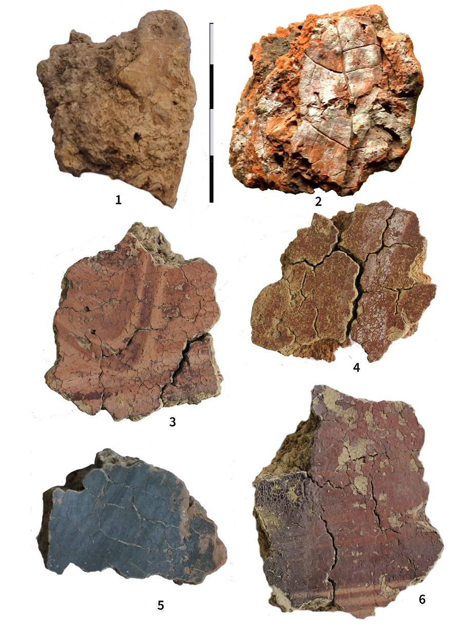
Fig. 10. Daub from Nebelivka houses: 1 – daub from mega-structure with part of figurine inside; 2 – daub from mega-structure with imprint of tree leaf; 3, 4, 6 – daub with wall-painting from house B-17; 5 – daub with graphite decoration, from altar; test-trench.
10 pav. Tinkas iš Nebelivka pastatų: 1 – tinkas iš megastruktūros su dalimi figūrėlės viduje; 2 – tinkas iš megastruktūros su medžio lapo įspaudu; 3, 4, 6 – tinkas su sienų tapybos elementais iš namo B-17; 5 – tinkas su grafito dekoru nuo altoriaus; žvalgomoji tranšėja
The construction of large buildings required significant resources, starting with building materials. According to approximate calculations a lot of wood was used in the construction of the megastructure in Nebelivka (fig. 8). About 50 cubic meters of clay were used to level the floor with a special type of clay in a layer 5–8 cm thick. Calculations show that the cost of resources for the construction of this widow can be compared with the construction of 25–30 ordinary houses.
A feature of most large structures is a greater width compared to ordinary buildings – from 8–10 to 20–25 m compared to the standard 4–6 m (Hofman et al., 2019, table 2 and fig. 17). As it was possible to trace during the excavations of such a building in Nebelivka, a system of supporting pillars, located from with an interval of about 4 m (Videiko, Burdo, 2020, fig. 11, - 2). In fact, the wide buildings consisted of modules with a width standard for conventional buildings.
Red paint is widely used in interior decoration, including walls and floors. Painting was updated, especially in the area of intensive movement of people. Thus, in one case, more than 8 layers of paint were found near the entrance to Nebelivka. From the interior details, attention is drawn to cross-shaped altars, already known both from the excavations of ordinary buildings and from ceramic models of buildings (fig. 8). These findings are distinguished by larger sizes. For example, one of the seven altars in a large building from Nebelivka was 4.4 m across. This is the building on which the fire was lit. The building was restored at least seven times, which is evidenced by layering. Thus, considerable efforts were directed not only to the construction of these large buildings, but also to maintaining them in proper condition (fig.10, 3–6).
The width of the door to the largest building in Nebelivka attracts attention. For the main entrance, it was 1.7 m (threshold width), and the next door was about 2 m. This allowed a large number of people to enter the building at the same time. Features of the layout, namely the large width of the premises, provided the opportunity for those present to observe and hear what is happening in the premises.
Even the smallest of the large structures were designed for the simultaneous stay of at least 100–150 people, and in the largest one this figure could be 4–5 times more. The presence of a large open space around the buildings made it possible for several hundred to several thousand inhabitants of the villages to stay here at the same time. In this way, large structures were built with the expectation of holding mass events. At the same time, no resources were spared either for construction or for their maintenance.
At the same time traces of rituals were detected at the other areas of the sites. Some of explored pits, including pits near the houses and pottery workshops, were used for storage of broken figurines (fig. 14), sometimes more than 20–40 samples, and animal bones, supplemented by ashes and charcoal.
Pottery workshops
The discovery of a new type of pottery kilns should be recognized as important event (fig.11–12). They were also discovered by magnetic surveying, and their excavations began in 2013 (Korvin-Piotrovskiy et al., 2020). To date, more than 20 such structures have been investigated.
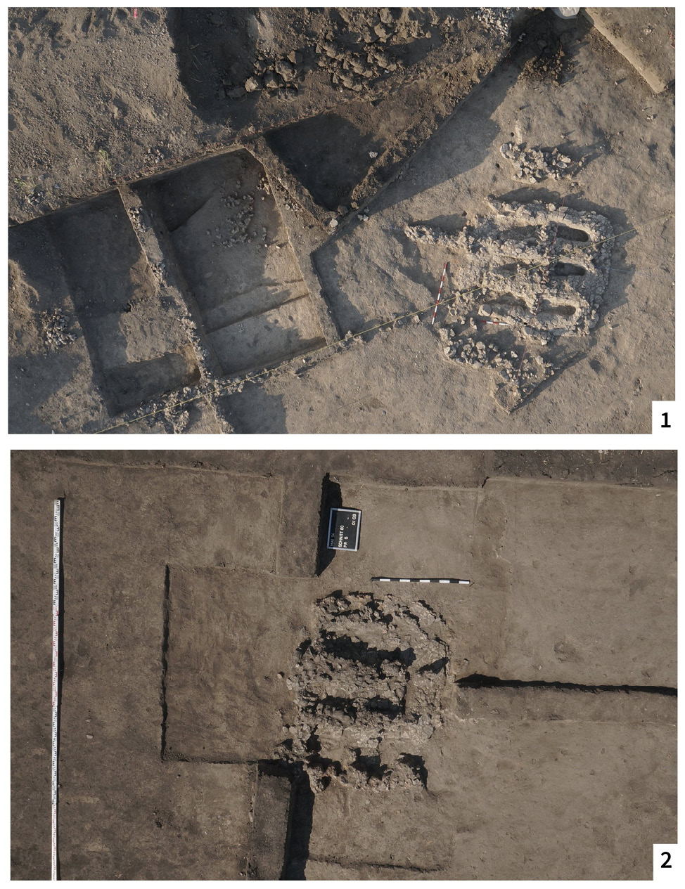
Fig. 11. Remains of the multi-channel pottery kilns: 1 – Nebelivka; 2 – Maidanetske.
11 pav. Keramikos krosnių liekanos: 1 – Nebelivka; 2 – Maidanetske
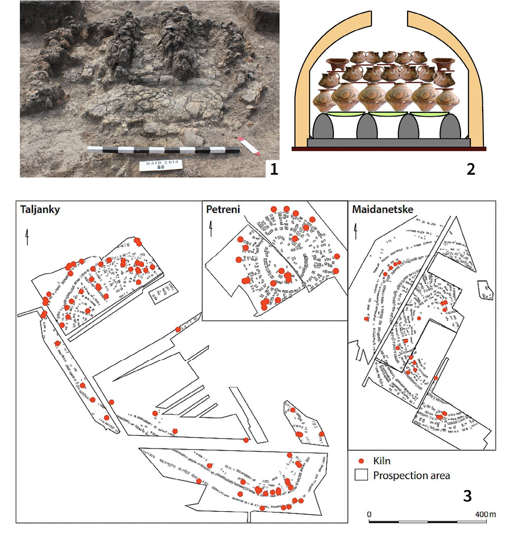
Fig. 12. Pottery-kilns at megasites: 1 – remains of pottery kiln from Maidanetske; 2 – pottery kiln, cross-section. Reconstruction of object from Nebelivka; 3 – location of pottery kilns at Talianky, Petreni and Maidanetske (after Korvin-Piotrovskiy et al., 2016).
12 pav. Keramikos krosnys megaobjektuose: 1 – Maidanecke keramikos krosnies liekanos; 2 – keramikos krosnis, pjūvis. Nebelivka krosnies rekonstrukcija; 3 – Talianky, Petreni ir Maidanetske keramikos krosnių liekanų vietos (pagal Korvin-Piotrovskiy et al., 2016)
The design of these kilns differed from the two-story ones known earlier. They had three to four channels located under the firing chamber. The furnace was brought out in front of the furnace (Korvin-Piotrovskiy et al., 2020, 221–252). This design made it possible to fire high-quality painted ceramics and to do it in large quantities (fig. 13). The time of the existence of the kilns of this design in the area of the Trypillia culture is between 4100 and 3400 BC.
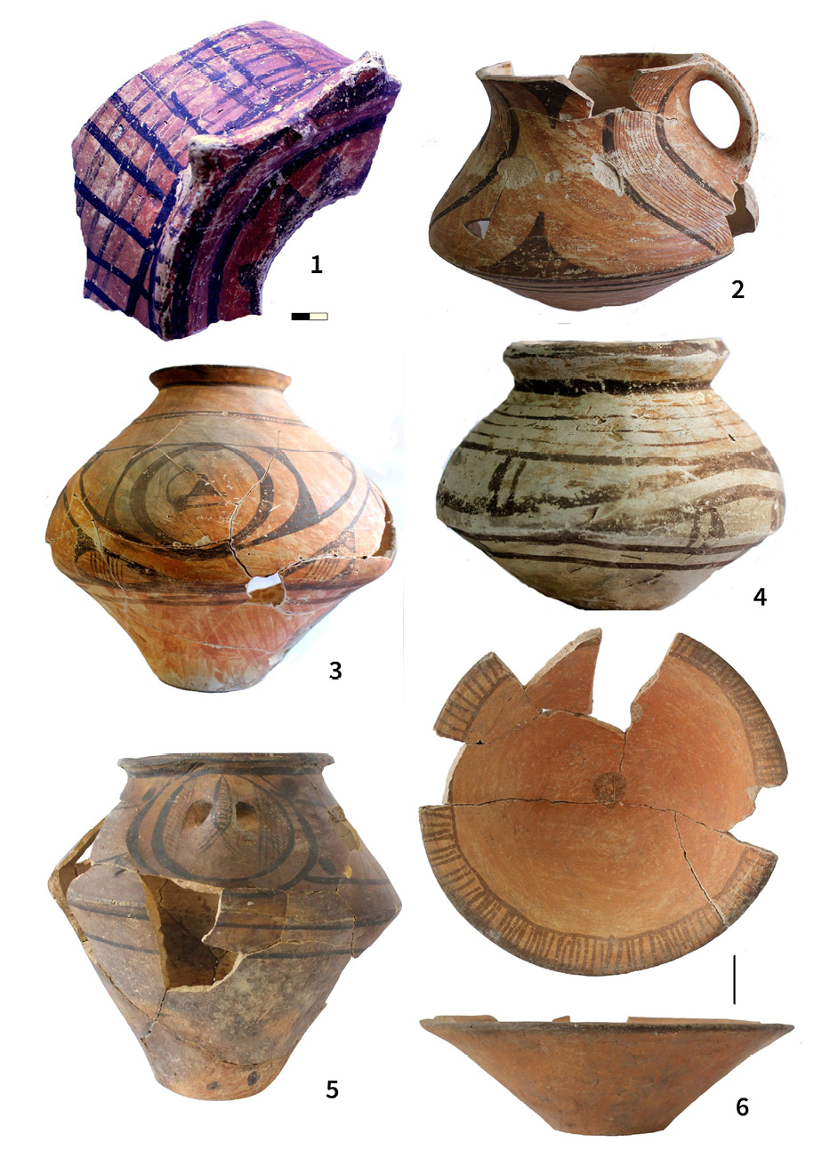
Fig. 13. Samples of production from pottery workshops: 1–4 – Nebelivka (1 – part of model of house; 2–3 – painted vessels); 5–6 – Maidanetske, painted pottery.
13 pav. Keramikos dirbtuvių produkcijos pavyzdžiai: 1–4 – Nebelivka (1 – namo modelio dalis; 2–3 – tapyti indai); 5–6 – Maidanetske, tapyta keramika
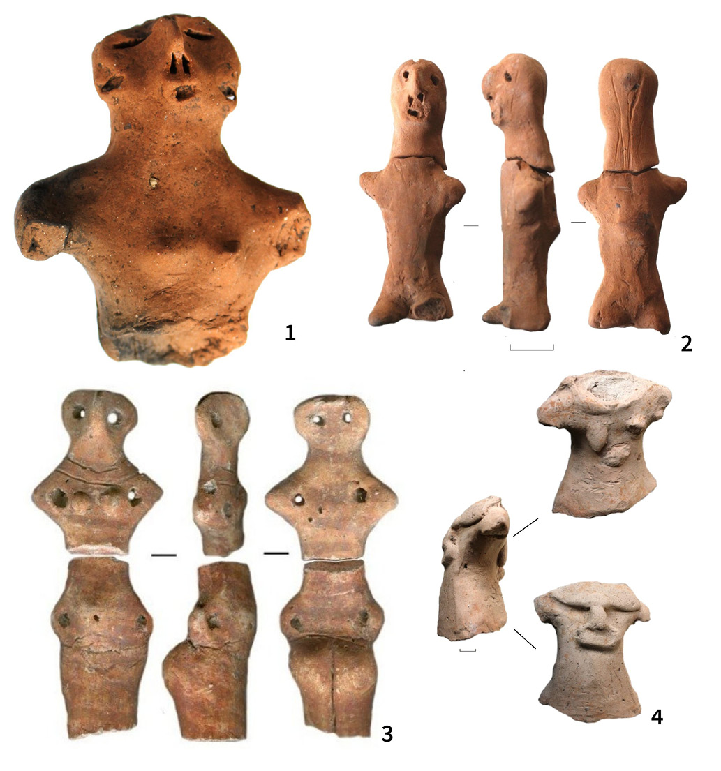
Fig. 14. Nebelivka, human figurines from pit near the pottery kiln, which was explored in 2014.
14 pav. Nebelivka, žmogaus figūrėlės iš duobės prie keramikos krosnies, kuri buvo tyrinėta 2014 m.
Most of them were found in megasites. Thus, it is known about the existence on studied areas of more than 60 kilns in Talyanki and more than 20 in Maidanetske and Petreni (Korvin-Piotrovskiy et al., 2020, fig. 39). Outside this region, there are well-known pits of this design in the area of the Shipintsy local group, east of the Dniester. Judging by the distribution of high-quality painted pottery, the probable territory of their distribution is from the Carpathian region to the middle course of the Dnieper (Videiko, 2019).
The using of pottery kilns of a similar design is known in the Mediterranean in 1700–1400 BC, where their existence is considered a sign of a highly developed craft (Shaw et al., 2001). Craftsmen also used them later, in Hellas and Rome, for the mass production of high-quality pottery. Thus, there is every reason to consider the fact of the existence of similar heat-technical devices in the east of Ancient Europe as a sign of the existence of the pottery craft and evidence of a high level of its development.
Concluding remarks
New research, carried out last 15 years on the eastern borders of Old Europe, has shown that after 4200 BC they became a place where ancient traditions were preserved. As a result of favorable climatic changes, rapid economic and corresponding social development took place here for about 700–800 years. The appearance of megasettlements, which continued the traditions of urbanization that started in the southeast and center of Europe before 4200 BC, became a regular phenomenon.
Large-scale works on the construction of fortifications and public buildings are connected with these settlements. The level of agriculture made possible the division of labor and the development of crafts, especially pottery with its multi-channel kilns.
Such megasites were economic, military, spiritual and political centers, surrounded by smaller sites. In general, we can talk about a fundamentally new, compared to previous stages, type of social organization in its various manifestations.
These discoveries sparked a debate about the beginning of the process of urbanization among the ancient farmers of Europe. Thus, news from the eastern borders of Old Europe adds new important details to its dramatic history.
Literature
Albert B., Innes J., Krementskiy K., Millard A.-R., Gaydarska B., Nebbia M., Chapman J. 2020. What was the ecological impact of a Trypillia mega-site occupation? Multi-proxy palaeo-environmental investigations at Nebelivka, Ukraine. Vegetation History and Archaeobotany, 29, p. 15–34. https://doi.org/10.1007/s00334-019-00730-9
Asăndulesei A. 2017. Inside a Cucuteni Settlement: Remote sensing Techniques for Documenting an Unexplored Eneolithic Site from Northeastern Romania. Remote sensing, 9/1, Article 41. https://doi.org/10.3390/rs9010041
Asăndulesei A., Adrian Tencariu F., Nicu I. 2020. Pars pro toto-Remote sensing Data for the Reconstruction of a Rounded Chalcolithic Site from NE Romania: The Case of Ripiceni-Holm Settlement (Cucuteni Culture). Remote sensing, 12, Article 887. https://doi.org/10.3390/rs12050887
Videiko M., Chapman J., Kozir I., Sobchuk V. (eds.). 2015. At the eastern frontiers of Old Europe. Proceedings of the International Conference in Kirovograd and Nebelivka, May 12–14 2015. Kirovograd.
Chapman J., Videiko M., Hale D., Gaydarska B., Burdo N., Rassmann K., Mischka C., Müller J., Korvin-Piotrovskiy A., Kruts V. 2014. The Second Phase of the Trypillia Mega-Site Methodological Revolution: A New Research Agenda. European Journal of Archaeology, 17/3, p. 369–406.
Chapman J., Gaydarska B., Videiko M., Burdo N., Pashkevych G., Ovchinnikov E., Rud V., Hale D. 2020. Early Urbanism in Europe The Trypillia Megasites of the Ukrainian Forest-Steppe. Warsaw/Berlin: De Gruyter Poland Ltd.
Dal Corso M., Welmoed O., Ohlrau R., Hofmann R., Dreibrot S., Videiko M., Muller J., Kirleis W. 2018. Where are the cereals? Contribution of phytolith analysis to the study of subsistence economy at the Trypillia site Maidanetske (ca. 3900–3650 BCE), central Ukraine. Journal of Arid Environments, 157/4, p. 137–148.
Dal Corso M., Hamer W., Hofmann R., Ohlrau R., Shatilo L., Knitter D., Dreibrodt S., Saggau P., Duttmann R., Feeser I., Knapp H., Benecke N., Videiko M., Müller J., Kirleis W. 2019. Modelling landscape transformation at the Chalcolithic Tripolye mega-site of Maidanetske (Ukraine): Wood demand and availability. The Holocene, 29/10, p. 1622–1636.
Dreibrodt S., Hofmann R., Sipos G., Schwark L., Videiko M., Shatilo L., Martini S., Saggau P., Bork H.-R., Kirleis W., Duttmann R., Müller J. 2020. Holocene soil erosion in Eastern Europe-land use and/or climate controlled? The example of a catchment at the Giant Chalcolithic settlement at Maidanetske, central Ukraine. Geomorphology, 30, p. 1–16.
Hofmann R., Muller J., Shatilo L., Videiko M., Ohlrau R., Rud V., Burdo N., Dal Corso M., Dreibrodt S., Kirleis W. 2019. Governing Tripolye: Integrative architecture in Tripolye settlements. PLoS ONE, 14/9, p. 1–54. https://doi.org/10.1371%2Fjournal.pone.0222243
Korvin-Piotrovskiy A., Hofmann R., Rassmann K., Videiko M., Brandstätter, L. 2020. Pottery Kilns in Trypillian Settlements. Tracing the Division of Labour and the Social Organization of Copper Age Communities. Trypillia Mega-Sites and European Prehistory: 4100–3400 BCE. Routledge.
Kruts, 1989 = Круц В. А. К истории населения трипольской культуры в междуречье Южного Буга и Днепра. С. Березанская (ред.) Первобытная археология: Материалы и исследования. Киев: Наукова думка, с. 117–132.
Muller J., Videiko M., Rassmann K. 2016. Trypillia-Megasites and European Prehistory. London and New York: Routledge, p. 221–252.
Makarewicz C. A., Hofmann R., Videiko M. Yu., Müller J. 2022. Community negotiation and pasture partitioning at the Trypillia settlement of Maidanetske. Antiquity, 96/388, p. 831–847.
Millard A. 2020. The AMS Dates. B. Gaydarska (ed.) Early Urbanism in Europe: The Trypillia Megasites of the Ukrainian Forest-Steppe. Warsaw/Berlin: De Gruyter Poland Ltd, p. 246–256. https://doi. Org/10.1515/9783110664959 2020
Muller J., Hofmann R., Brandstatter L., Ohlrau R., Videiko M. 2016a. Chronology and Demography: How Many People Lived in a Mega-Site? J. Müller, K. Rassmann, M. Videiko (eds.) Trypillia-Megasites and European Prehistory. London and New York: Routledge, p. 133–169.
Müller J., Videiko M. 2016b. Maidanetske: New Facts of a Mega-Site. J. Müller, K. Rassmann, M. Videiko (eds.) Trypillia Mega-sites and European Prehistory: 4100–3400 BCE. London and New York: Routledge, p. 71–94.
Müller J., Hofmann R., Videiko M., Burdo N. 2022. Nebelivka – rediscovered: A Lost City. Festschrift for Professor Sławomir Kadrow, in press.
Ohlrau R., Rud V. 2019. Testing Trypillian site development via geomagnetic survey. New «mega-structures» and plans of smaller sites. Beyond Excavation. Geophysics, Aerial Photography and the use of Drones in Eastern and Southeastern European Archaeology. Proceedings of the International Colloquium 5–8 December 2016, Piatra-Neamţ, Romania. Bibliotheca Memoriae Antiquitatis, XL. Piatra-Neamţ: Constantin Matasă, р. 87–114.
Rassmann K., Videjko M., Peters D., Gauss R. 2014. Großflächige geomagnetische Untersuchungen kupferzeitlicher Siedlung der Trypillia-Kultur. Aktuelle Prospektionen in Taljanky und Maydanetske (Ukraine). W. Schier and F. Drasovean (eds.) The Neolithic and eneolithic in Southeast Europe new approaches to dating and cultural dynamics in the 6th to 4th millennium BC. Rahden, s. 99–112.
Rud, 2015 = Рудь В. Дослідження залишків жител на розкопі 5 поселення Небелівкаю. M. Videiko, J. Chapman, I. Kozir, V. Sobchuk (eds.) At the eastern frontiers of Old Europe. Proceedings of the International Conference in Kirovograd and Nebelivka, 12–14 May 2015. Kirovograd, museum, p. 26–27.
Rud V., Hofmann R., Kosakivskyi V., Zaitseva O., Müller J. 2019. Trypillia mega-sites west of Southern Buh River: Preliminary results of Bilyi Kamin site investigation in 2018. Journal of Neolithic Archaeology, 21, p. 27–60.
Shaw W., Van de Moortel A., Day P., Kilikoglu V. 2001. LM IA Ceramic Kiln in South – central Crete: Function and Pottery Production. Hesperia Supplement 30/2001, p. 1–268.
Shukurov A., Sarson G., Videiko M., Henderson K., Shiel R., Dolukhanov P., Pashkevich G. 2015. Productivity of premodern agriculture in the Cucuteni-Trypillia area. Human Biology, 87, p. 235–282.
Ţerna S., Rassmann K., Vasilache M., Radloff K., Stolniceni I. 2016. New research on a Cucuteni-Tripolye large site. A. Zanoci, E. Kaiser, M. Kashuba, M. B. Izbitser (eds.) Mensch, Kultur und Gesellschaft von der Kupferzeit bis zur frühen Eisenzeit im nördlichen Eurasien. Beiträge zu Ehren zum 60. Geburtstag von Eugen Sava. Man, Culture, and Society from the Copper Age until the Early Iron Age in Northern Eurasia. Contributions in Honour of the 60th Anniversary of Eugen Sava. Tyragetia International, 1, Chişinău , p. 41–52.
Uhl R. A., Vasilache-Curoşu M., Sirbu M., Sirbu L., Bicbaev V., Steiniger D., Zidarov P., Sava E., Hansen S. 2014. Petreni in der nördlichen Moldaurepublik. Bericht über die Ausgrabungen der Jahre 2011–2013. Eurasia Antiqua, 20, p. 185–206.
Shmaglij,Videiko,1993 = Шмаглій М. М., Відейко М. Ю. Трипільські протоміста. Археологія, 3, с. 52–63.
Videiko M. 2013. Investigations of microchronology of large sites of Trypillia culture. Revista Arheologică, serie nouă, IX/1, p. 88–97.
Videiko M. 2019. The channel kilns in Trypillia Culture and development of pottery production. Tyragetia, 9, s.n., XIII(1), p. 9–26.
Videiko M. 2021. Geophysical research at the beginning of the 21th century: «rediscovery» of the cultural complex Precucuteni-Cucuteni-Trypillia. Археологія і давня історія України, 2/39, c. 306–317.
Videiko M., Burdo N. 2020. Mega-structure from Nebelivka – the largest temple of Trypillia culture. A. Melniciuc, B. Petru, N. Sorin, S. Enea (eds.) Eternitatea Arheologiei Studii în Onoarea Profesorului Dumitru Boghian La A 65-A Aniversare. Cluj-Napoca, Editura Mega, p. 247–262.
Videiko M., Burdo N., Sliesariev Ye., Muller J., Hoffman R., Ohlrau R. 2017. Maidanetske 2016: excavations at a Trypillia Mega-site. Trypillia Civalization journal. https://www.trypillia.com/archives2017/124-m-videiko-n-burdo-ye-sliesariev-y-muller-r-hoffman-r-ulrau-maidanetske-2016-excavations-at-a-trypillia-mega-site
Wenninger B., Harper T. 2015. The Geographic Corridor for Rapid Climate Change in Southeast Europe and Ukraine. E. Schultze (ed.) Neolithic and Copper Age between the Carpathians and the Aegean, 31. Archaologie in Eurasien. DAI, Berlin, p. 475–505.